Circles of latitude between the 30th parallel north and the 35th parallel north
Following are circles of latitude between the 30th parallel north and the 35th parallel north:
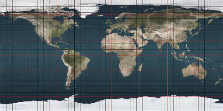
31st parallel north
.svg.png)

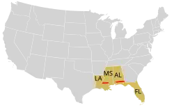
The 31st parallel north is a circle of latitude that is 31 degrees north of the Earth's equatorial plane. It crosses Africa, Asia, the Pacific Ocean, North America, and the Atlantic Ocean. At this latitude the sun is visible for 14 hours, 10 minutes during the summer solstice and 10 hours, 8 minutes during the winter solstice.[1]
Part of the border between Iran and Iraq is defined by the parallel.
In the United States, it defines part of the border between the states of Mississippi and Louisiana, and most of the border between Alabama and Florida. Andrew Ellicott surveyed this parallel in 1797, which in Pinckney's Treaty two years before had been defined as the border between the United States and the Spanish territory of West Florida.
Around the world
Starting at the Prime Meridian and heading eastwards, the parallel 31° north passes through:
32nd parallel north
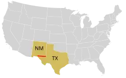
The 32nd parallel north is a circle of latitude that is 32 degrees north of the Earth's equatorial plane. It crosses Africa, Asia, the Pacific Ocean, North America, and the Atlantic Ocean.
In the United States, the parallel defines part of the border between New Mexico and Texas. It was the proposed route of the Texas Pacific Railroad.[2]
From 27 August 1992 to 4 September 1996, the parallel defined the limit of the southern no-fly zone in Iraq as part of Operation Southern Watch. This limit was then moved to the 33rd parallel north.[3]
At this latitude the sun is visible for 14 hours, 15 minutes during the summer solstice and 10 hours, 3 minutes during the winter solstice.[4]
Around the world
Starting at the Prime Meridian and heading eastwards, the parallel 32° north passes through:
Coordinates Country, territory or sea Notes 32°0′N 0°0′E / 32.000°N 0.000°E  Algeria
Passing just north of Ouargla 32°0′N 9°8′E / 32.000°N 9.133°E  Tunisia
32°0′N 10°47′E / 32.000°N 10.783°E  Libya
Libya32°0′N 15°21′E / 32.000°N 15.350°E Mediterranean Sea Gulf of Sirte 32°0′N 19°58′E / 32.000°N 19.967°E Libya32°0′N 24°49′E / 32.000°N 24.817°E Mediterranean Sea 32°0′N 34°44′E / 32.000°N 34.733°E  Israel
Passing through: holon
beit dagan
Tel Aviv's Ben Gurion Airport
shoham32°0′N 35°0′E / 32.000°N 35.000°E West Bank Controlled by Israel and  Palestine
32°0′N 35°32′E / 32.000°N 35.533°E  Jordan
Passing through Khilda, northwestern Amman 32°0′N 39°0′E / 32.000°N 39.000°E  Saudi Arabia
32°0′N 40°6′E / 32.000°N 40.100°E  Iraq
IraqPassing through Al Diwaniyah 32°0′N 47°42′E / 32.000°N 47.700°E  Iran
Iran32°0′N 60°50′E / 32.000°N 60.833°E  Afghanistan
32°0′N 69°18′E / 32.000°N 69.300°E  Pakistan
Balochistan - for about 16 km
Khyber Pakhtunkhwa
Punjab32°0′N 74°50′E / 32.000°N 74.833°E  India
IndiaPunjab
Himachal Pradesh32°0′N 78°44′E / 32.000°N 78.733°E  People's Republic of China
Tibet
Qinghai
Tibet (for about 12 km)
Qinghai (for about 6 km)
Tibet (for about 4 km)
Qinghai (for about 4 km)
Tibet
Sichuan
Chongqing
Shaanxi
Hubei
Henan
Anhui
Jiangsu — passing just south of Nanjing32°0′N 121°45′E / 32.000°N 121.750°E East China Sea 32°0′N 130°11′E / 32.000°N 130.183°E  Japan
JapanIsland of Kyūshū:
— Kagoshima Prefecture
— Miyazaki Prefecture32°0′N 131°30′E / 32.000°N 131.500°E Pacific Ocean 32°0′N 116°51′W / 32.000°N 116.850°W  Mexico
Baja California - passing 10 km north of Ensenada
Sonora32°0′N 113°12′W / 32.000°N 113.200°W .png) United States
United StatesCalifornia - Passing through San Diego County Arizona
New Mexico
New Mexico / Texas border
Texas — passing through the cities of Midland and Hillsboro
Louisiana
Mississippi
Alabama
Georgia — passing through the city of Savannah32°0′N 80°50′W / 32.000°N 80.833°W Atlantic Ocean Passing just south of  Bermuda
Passing just south of the Desertas Islands, Madeira, Portugal
32°0′N 9°22′W / 32.000°N 9.367°W  Morocco
32°0′N 2°56′W / 32.000°N 2.933°W Algeria
33rd parallel north
The 33rd parallel north is a circle of latitude that is 33 degrees north of the Earth's equatorial plane. It is approximate at the midpoint between the equator (0 degrees) and the Arctic Circle (66.6 degrees North Latitude.) It crosses North Africa, Asia, the Pacific Ocean, North America and the Atlantic Ocean.
In Iraq, the parallel defined the limit of the southern no-fly zone from 4 September 1996 to 30 August 2003. (Before this time, it had been set at the 32nd parallel north) as part of Operation Southern Watch.[5]
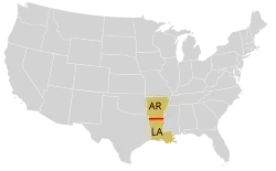
In the United States, it approximately forms the border between Arkansas in the north and Louisiana on the south. (The border is actually a couple of kilometres north of the parallel.) The Louisiana Territory was that part of the 1803 Louisiana Purchase which lay north of the 33rd parallel.
The parallel is part of the horse latitudes.
At this latitude the sun is visible for 14 hours, 20 minutes during the summer solstice and 9 hours, 58 minutes during the winter solstice.[6]
Around the world
Starting at the prime meridian and heading eastwards, the parallel 33° north passes through:
Coordinates Country, territory or sea Notes 33°0′N 0°0′E / 33.000°N 0.000°E Algeria33°0′N 8°11′E / 33.000°N 8.183°E Tunisia33°0′N 11°31′E / 33.000°N 11.517°E Libya33°0′N 12°0′E / 33.000°N 12.000°E Mediterranean Sea Passing just north of Tripoli, Libya33°0′N 35°5′E / 33.000°N 35.083°E IsraelPassing through Nahariya and Amuka 33°0′N 35°38′E / 33.000°N 35.633°E Golan Heights Territory controlled by Israel, claimed by .svg.png) Syria – passing through the northern edge of Katzrin
Syria – passing through the northern edge of Katzrin33°0′N 35°52′E / 33.000°N 35.867°E UNDOF buffer zone About 500 m (1,640 ft) 33°0′N 35°53′E / 33.000°N 35.883°E Syria33°0′N 38°5′E / 33.000°N 38.083°E Jordan33°0′N 39°3′E / 33.000°N 39.050°E IraqPassing just south of Baghdad 33°0′N 46°6′E / 33.000°N 46.100°E Iran33°0′N 60°38′E / 33.000°N 60.633°E Afghanistan33°0′N 69°30′E / 33.000°N 69.500°E PakistanKhyber Pakhtunkhwa Punjab
Azad Kashmir – claimed by India33°0′N 74°21′E / 33.000°N 74.350°E IndiaJammu and Kashmir – claimed by Pakistan
Ladakh – claimed by Pakistan
Himachal Pradesh33°0′N 79°14′E / 33.000°N 79.233°E Aksai Chin Disputed between India and People's Republic of China33°0′N 79°21′E / 33.000°N 79.350°E People's Republic of ChinaTibet
Qinghai
Sichuan
Qinghai
Sichuan
Gansu
Shaanxi
Hubei
Henan
Anhui
Jiangsu
Anhui (for about 12 km (7.5 mi))
Jiangsu33°0′N 126°16′E / 33.000°N 126.267°E South Korea Sea Passing just south of the island of Marado,  South Korea
33°0′N 129°2′E / 33.000°N 129.033°E JapanIsland of Nakadōri:
— Nagasaki Prefecture
Island of Kyūshū:
— Nagasaki Prefecture
— Saga Prefecture
— Kumamoto Prefecture
— Ōita Prefecture
Island of Shikoku:
— Ehime Prefecture
— Kōchi Prefecture33°0′N 133°1′E / 33.000°N 133.017°E Pacific Ocean 33°0′N 118°35′W / 33.000°N 118.583°W United StatesCalifornia – Northern tip of San Clemente Island 33°0′N 118°33′W / 33.000°N 118.550°W Pacific Ocean 33°0′N 117°17′W / 33.000°N 117.283°W United StatesCalifornia – passing through Solana Beach and just north of Brawley
Arizona – passing through Casa Grande Ruins National Monument
New Mexico
Texas – passing through the Dallas–Fort Worth metroplex
Louisiana – passing just south of the border with Arkansas
Mississippi
Alabama
Georgia – passing through LaGrange, and Louisville
South Carolina – passing through Goose Creek33°0′N 79°28′W / 33.000°N 79.467°W Atlantic Ocean 33°0′N 16°23′W / 33.000°N 16.383°W PortugalCal Islet, just south of Porto Santo Island, Madeira 33°0′N 16°22′W / 33.000°N 16.367°W Atlantic Ocean 33°0′N 8°45′W / 33.000°N 8.750°W MoroccoPassing through Settat 33°0′N 1°28′W / 33.000°N 1.467°W Algeria
34th parallel north
The 34th parallel north is a circle of latitude that is 34 degrees north of the Earth's equatorial plane. It crosses Africa, the Mediterranean Sea, Asia, the Pacific Ocean, North America and the Atlantic Ocean.
The parallel formed the southern boundary of the original Colony of Virginia as outlined in the London Company charter.[7]
In the Confederate States, the parallel formed the northern boundary of Arizona Territory.[8]
At this latitude the sun is visible for 14 hours, 25 minutes during the summer solstice and 9 hours, 53 minutes during the winter solstice.[9]
Around the world
Starting at the Prime Meridian and heading eastwards, the parallel 34° north passes through:
Coordinates Country, territory or sea Notes 34°0′N 0°0′E / 34.000°N 0.000°E Algeria34°0′N 7°33′E / 34.000°N 7.550°E Tunisia34°0′N 10°3′E / 34.000°N 10.050°E Mediterranean Sea Passing just north of Beirut,  Lebanon
34°0′N 35°39′E / 34.000°N 35.650°E Lebanon34°0′N 36°22′E / 34.000°N 36.367°E Syria34°0′N 40°6′E / 34.000°N 40.100°E Iraq34°0′N 45°27′E / 34.000°N 45.450°E IranKermanshah
Kurdistan
Lorestan
Hamadan
Markazi
Qom
Isfahan
Semnam
South Khorasan
Razavi Khorasan34°0′N 60°30′E / 34.000°N 60.500°E Afghanistan34°0′N 69°54′E / 34.000°N 69.900°E PakistanKhyber Pakhtunkhwa 34°0′N 70°10′E / 34.000°N 70.167°E Afghanistan34°0′N 70°55′E / 34.000°N 70.917°E PakistanKhyber Pakhtunkhwa - for about 8 km (5.0 mi)
Khyber Pakhtunkhwa
Punjab - for about 3 km (1.9 mi)
Azad Kashmir - claimed by India34°0′N 74°15′E / 34.000°N 74.250°E IndiaJammu and Kashmir - Passing through Srinagar-claimed by Pakistan
Ladakh - claimed by Pakistan34°0′N 78°45′E / 34.000°N 78.750°E Aksai Chin Disputed between India and People's Republic of China34°0′N 78°54′E / 34.000°N 78.900°E People's Republic of ChinaTibet
Qinghai
Sichuan − for about 4 km (2.5 mi)
Qinghai
Gansu
Sichuan
Gansu
Shaanxi
Henan
Anhui
Henan
Anhui
Jiangsu − for about 5 km (3.1 mi)
Anhui − for about 4 km (2.5 mi)
Jiangsu34°0′N 120°23′E / 34.000°N 120.383°E East China Sea Passing by several islands of South Korea34°0′N 127°19′E / 34.000°N 127.317°E South KoreaPort Hamilton islands 34°0′N 127°20′E / 34.000°N 127.333°E Korea Strait Passing just south of Tsushima Island, Japan34°0′N 130°55′E / 34.000°N 130.917°E JapanIsland of Honshū:
— Yamaguchi Prefecture - passing through the northern suburbs of Shimonoseki
Island of Shikoku:
— Ehime Prefecture
— Tokushima Prefecture
Island of Honshū:
— Wakayama Prefecture
— Nara Prefecture
— Mie Prefecture34°0′N 136°16′E / 34.000°N 136.267°E Pacific Ocean Passing between the islands of Miyakejima and Mikurajima, Japan
Passing just south of San Miguel Island, California, United States34°0′N 120°14′W / 34.000°N 120.233°W United StatesCalifornia - Santa Rosa Island and Santa Cruz Island 34°0′N 119°33′W / 34.000°N 119.550°W Pacific Ocean Passing just south of Anacapa Island, California, United States34°0′N 118°29′W / 34.000°N 118.483°W United StatesCalifornia - passing through Los Angeles
Arizona
New Mexico
Texas - passing through Sheppard AFB
Oklahoma - passing through Durant and Hugo
Arkansas
Mississippi
Alabama
Georgia - passing through Kennesaw and Athens
South Carolina - passing through Columbia
North Carolina - passing through Kure Beach34°0′N 77°54′W / 34.000°N 77.900°W Atlantic Ocean 34°0′N 6°53′W / 34.000°N 6.883°W MoroccoPassing through Rabat and Fez 34°0′N 1°40′W / 34.000°N 1.667°W Algeria
35th parallel north
The 35th parallel north is a circle of latitude that is 35 degrees north of the Earth's equatorial plane. It crosses Africa, the Mediterranean Sea, Asia, the Pacific Ocean, North America and the Atlantic Ocean.
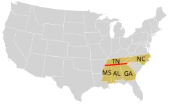
In the United States, the parallel defines the southern border of Tennessee, and the border between North Carolina and Georgia, as well as the tripoint of Arizona–California–Nevada.
At this northern latitude, the Sun is visible for 14 hours, 31 minutes on its summer solstice (in June) and for 9 hours, 48 minutes on its winter solstice (in December).[10]
This parallel is sometimes used to define the northern boundary of the subtropics.
Around the world
Starting at the Prime Meridian and heading eastwards, the parallel 35° north passes through:
Coordinates Country, territory or sea Notes 35°0′N 0°0′E / 35.000°N 0.000°E Algeria35°0′N 8°19′E / 35.000°N 8.317°E Tunisia35°0′N 10°58′E / 35.000°N 10.967°E Mediterranean Sea 35°0′N 24°45′E / 35.000°N 24.750°E  Greece
Island of Crete 35°0′N 25°34′E / 35.000°N 25.567°E Mediterranean Sea 35°0′N 32°18′E / 35.000°N 32.300°E  Cyprus
Including, for a short distance, the United Nations Buffer Zone in Cyprus 35°0′N 33°43′E / 35.000°N 33.717°E Dhekelia  United Kingdom Sovereign Base Area (not part of the territory of the Republic of Cyprus)
35°0′N 33°51′E / 35.000°N 33.850°E Cyprus35°0′N 34°4′E / 35.000°N 34.067°E Mediterranean Sea 35°0′N 35°54′E / 35.000°N 35.900°E Syria35°0′N 41°14′E / 35.000°N 41.233°E Iraq35°0′N 45°53′E / 35.000°N 45.883°E IranPassing through Saveh 35°0′N 61°7′E / 35.000°N 61.117°E Afghanistan35°0′N 71°31′E / 35.000°N 71.517°E PakistanKhyber Pakhtunkhwa
Azad Kashmir – claimed by India
Gilgit-Baltistan – claimed by India35°0′N 77°1′E / 35.000°N 77.017°E IndiaLadakh – claimed by Pakistan35°0′N 78°7′E / 35.000°N 78.117°E Aksai Chin Disputed between India and People's Republic of China35°0′N 80°11′E / 35.000°N 80.183°E People's Republic of ChinaTibet
Qinghai
Gansu
Shaanxi
Gansu
Shaanxi
Shanxi
Henan
Shandong
Jiangsu35°0′N 119°12′E / 35.000°N 119.200°E Yellow Sea 35°0′N 126°6′E / 35.000°N 126.100°E South KoreaSouth Jeolla Province
passing through Muan AirportSouth Gyeongsang Province
passing just south of Busan35°0′N 128°50′E / 35.000°N 128.833°E Sea of Japan 35°0′N 132°12′E / 35.000°N 132.200°E JapanIsland of Honshu:
— Shimane Prefecture
— Hiroshima Prefecture
— Okayama Prefecture
— Hyōgo Prefecture
— Osaka Prefecture
— Kyoto Prefecture – passing through central Kyoto city
— Shiga Prefecture – passing through central Ōtsu city
— Mie Prefecture
— Aichi Prefecture
— Shizuoka Prefecture – passing just north of Shizuoka city35°0′N 139°6′E / 35.000°N 139.100°E Pacific Ocean Sagami Bay 35°0′N 139°51′E / 35.000°N 139.850°E JapanIsland of Honshu:
— Chiba Prefecture – the southern tip of the Bōsō Peninsula35°0′N 139°59′E / 35.000°N 139.983°E Pacific Ocean 35°0′N 120°38′W / 35.000°N 120.633°W United StatesCalifornia – passing just north of Santa Maria
Arizona–California–Nevada tripoint
Arizona
New Mexico – passing just south of Albuquerque
Texas
Oklahoma
Arkansas
Tennessee / Mississippi border - passing through the Memphis metropolitan area
Tennessee / Alabama border
Tennessee / Georgia border - passing through the Chattanooga metropolitan area
North Carolina / Georgia border
South Carolina
North Carolina – passing through Fayetteville35°0′N 76°8′W / 35.000°N 76.133°W Atlantic Ocean 35°0′N 6°15′W / 35.000°N 6.250°W MoroccoPassing through Ksar el-Kebir 35°0′N 2°8′W / 35.000°N 2.133°W Algeria
See also
References
- ↑ "Duration of Daylight/Darkness Table for One Year". U.S. Naval Observatory. 2019-09-24. Archived from the original on 2019-10-12. Retrieved 2021-03-10.
- ↑ Means, Richard Nathaniel Griffith (August 2001). Empire, Progress, and the American Southwest: The Texas and Pacific Railroad, 1850-1882 (PhD thesis). University of Southern Mississippi. ProQuest 304724941.
- ↑ "Containment: The Iraqi no-fly zones". BBC News. 29 December 1998. Retrieved 4 February 2012.
- ↑ "Duration of Daylight/Darkness Table for One Year". U.S. Naval Observatory. 2019-09-24. Archived from the original on 2019-10-12. Retrieved 2021-03-10.
- ↑ "Containment: The Iraqi no-fly zones". BBC News. 29 December 1998. Retrieved 4 February 2012.
- ↑ "Duration of Daylight/Darkness Table for One Year". U.S. Naval Observatory. 2019-09-24. Archived from the original on 2019-10-12. Retrieved 2021-03-10.
- ↑ "The First Charter of Virginia; April 10, 1606". The Avalon Project. 2008.
- ↑ "Confederate Statutes - CHAP. XLIV.--An Act to organize the Territory of Arizona - 1862, Jan. 18".
- ↑ "Duration of Daylight/Darkness Table for One Year". Archived from the original on 2007-12-23.
- ↑ "Duration of Daylight/Darkness Table for One Year". U.S. Naval Observatory. 2019-09-24. Archived from the original on 2019-10-12. Retrieved 2021-03-10.
Circles of latitude / meridians | |
|---|---|
45x90
45x90
45x90
45x90
|