Circles of latitude between the 40th parallel south and the 45th parallel south
Following are circles of latitude between the 40th parallel south and the 45th parallel south:
41st parallel south
.svg.png)
The 41st parallel south is a circle of latitude that is 41 degrees south of the Earth's equatorial plane. It crosses the Atlantic Ocean, the Indian Ocean, Australasia, the Pacific Ocean and South America.
At this latitude the sun is visible for 15 hours, 8 minutes during the December solstice and 9 hours, 13 minutes during the June solstice.
Around the world
Starting at the Prime Meridian and heading eastwards, the parallel 41° south passes through:
42nd parallel south
The 42nd parallel south is a circle of latitude that is 42 degrees south of the Earth's equatorial plane. It crosses the Atlantic Ocean, the Indian Ocean, Australasia, the Pacific Ocean and South America.
At this latitude the sun is visible for 15 hours, 15 minutes during the December solstice and 9 hours, 7 minutes during the June solstice.
The alcohol brand 42 Below was named in part because the 42nd parallel South passes through New Zealand.
Around the world
Starting at the Prime Meridian and heading eastwards, the parallel 42° south passes through:
Coordinates Country, territory or ocean Notes 42°0′S 0°0′E / 42.000°S 0.000°E Atlantic Ocean 42°0′S 20°0′E / 42.000°S 20.000°E Indian Ocean 42°0′S 145°13′E / 42.000°S 145.217°E .svg.png) Australia
AustraliaTasmania 42°0′S 148°17′E / 42.000°S 148.283°E Pacific Ocean Tasman Sea 42°0′S 171°23′E / 42.000°S 171.383°E  New Zealand
South Island 42°0′S 174°0′E / 42.000°S 174.000°E Pacific Ocean 42°0′S 74°3′W / 42.000°S 74.050°W  Chile
ChileChiloé Island (Los Lagos Region) 42°0′S 73°30′W / 42.000°S 73.500°W Pacific Ocean Gulf of Ancud 42°0′S 72°44′W / 42.000°S 72.733°W ChileLos Lagos Region 42°0′S 71°46′W / 42.000°S 71.767°W  Argentina
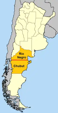
The parallel defines the border between Río Negro Province and Chubut Province[1][2] 42°0′S 65°4′W / 42.000°S 65.067°W Atlantic Ocean
43rd parallel south
The 43rd parallel south is a circle of latitude that is 43 degrees south of the Earth's equatorial plane. It crosses the Atlantic Ocean, the Indian Ocean, Australasia, the Pacific Ocean and South America.
On December solstice the sun is at 70.83 degrees in the sky and on June solstice it is at 23.17 degrees.
At this latitude the sun is visible for 15 hours, 22 minutes during the Summer Solstice and 9 hours, 0 minutes during the Winter Solstice.
Around the world
Starting at the Prime Meridian and heading eastwards, the parallel 43° south passes through:
Coordinates Country, territory or ocean Notes 43°0′S 0°0′E / 43.000°S 0.000°E Atlantic Ocean 43°0′S 20°0′E / 43.000°S 20.000°E Indian Ocean 43°0′S 145°36′E / 43.000°S 145.600°E AustraliaTasmania 43°0′S 147°57′E / 43.000°S 147.950°E Pacific Ocean Tasman Sea 43°0′S 170°34′E / 43.000°S 170.567°E New ZealandWest Coast region, Canterbury region 43°0′S 173°7′E / 43.000°S 173.117°E Pacific Ocean 43°0′S 74°15′W / 43.000°S 74.250°W ChileChiloé Island, Los Lagos Region 43°0′S 73°21′W / 43.000°S 73.350°W Pacific Ocean Gulf of Corcovado 43°0′S 72°45′W / 43.000°S 72.750°W ChileLos Lagos Region 43°0′S 72°3′W / 43.000°S 72.050°W ArgentinaChubut Province 43°0′S 64°20′W / 43.000°S 64.333°W Atlantic Ocean
44th parallel south
The 44th parallel south is a circle of latitude that is 44 degrees south of the Earth's equatorial plane. It crosses the Atlantic Ocean, the Indian Ocean, Australasia, the Pacific Ocean and South America.
At this latitude the sun is visible for 15 hours, 29 minutes during the December solstice and 8 hours, 53 minutes during the June solstice.
Around the world
Starting at the Prime Meridian and heading eastwards, the parallel 44° south passes through:
Coordinates Country, territory or ocean Notes 44°0′S 0°0′E / 44.000°S 0.000°E Atlantic Ocean 44°0′S 20°0′E / 44.000°S 20.000°E Indian Ocean 44°0′S 147°0′E / 44.000°S 147.000°E Pacific Ocean Tasman Sea 44°0′S 168°30′E / 44.000°S 168.500°E New ZealandWest Coast region
Otago region (briefly)
Canterbury region – passing through Lake Tekapo and Hinds
44°0′S 171°56′E / 44.000°S 171.933°E Pacific Ocean 44°0′S 176°39′W / 44.000°S 176.650°W New ZealandChatham Island 44°0′S 176°24′W / 44.000°S 176.400°W Pacific Ocean 44°0′S 74°15′W / 44.000°S 74.250°W ChileLeucayec Island, Guaitecas Archipelago, Aysén Region. 44°0′S 73°36′W / 44.000°S 73.600°W Pacific Ocean Gulf of Corcovado 44°0′S 73°16′W / 44.000°S 73.267°W ChileNorthern slopes of Melimoyu volcano, Aysén Region. 44°0′S 71°44′W / 44.000°S 71.733°W ArgentinaChubut Province 44°0′S 65°15′W / 44.000°S 65.250°W Atlantic Ocean
45th parallel south
The 45th parallel south is a circle of latitude that is 45° south of the Earth's equator.
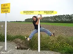
It is the line that marks the theoretical halfway point between the equator and the South Pole. The true halfway point is 16.2 km (10.1 mi) south of this parallel because Earth is not a perfect sphere, but bulges at the equator and is flattened at the poles.[3]
Unlike its northern counterpart, almost all (97%) of it passes through open ocean. It crosses the South Atlantic Ocean, the Indian Ocean, Australasia (New Zealand and just south of Tasmania), the Southern Ocean, and Patagonia.
At this latitude, daytime lasts for 15 hours, 37 minutes during the December solstice and 8 hours, 46 minutes during the June solstice for the dates in 2024.[4] This holds true regardless of longitude. The midday Sun stands 21.17° above the northern horizon at the June solstice, 68.83° at the December solstice, and exactly 45.0° at either equinox.
Around the world
Starting at the Prime Meridian and heading eastwards, the parallel 45° south passes through:
Coordinates Country, territory or ocean Notes 45°0′S 0°0′E / 45.000°S 0.000°E Atlantic Ocean 45°0′S 20°0′E / 45.000°S 20.000°E Indian Ocean 45°0′S 147°0′E / 45.000°S 147.000°E Pacific Ocean Tasman Sea 45°0′S 167°8′E / 45.000°S 167.133°E New ZealandSouth Island, passing just north of the towns of Oamaru, Naseby, Cromwell and Queenstown, and through the small settlement of Becks 45°0′S 171°6′E / 45.000°S 171.100°E Pacific Ocean Passing just south of Guamblin Island, Chile45°0′S 74°23′W / 45.000°S 74.383°W ChileIslands in the Chonos Archipelago including James Island and Melchor Island, and Moraleda Channel before reaching the mainland near Macá Volcano. 45°0′S 71°33′W / 45.000°S 71.550°W ArgentinaChubut Province 45°0′S 65°35′W / 45.000°S 65.583°W Atlantic Ocean
See also
- 45×90 points
- Circles of latitude between the 35th parallel south and the 40th parallel south
- Circles of latitude between the 45th parallel south and the 50th parallel south
Circles of latitude / meridians | |
|---|---|
45x90
45x90
45x90
45x90
|
See also
References
- ↑ "The Encyclopaedia Britannica: A Dictionary of Arts, Sciences, Literature and General Information". University Press. March 29, 1911 – via Google Books.
- ↑ Peri, Pablo L.; Pastur, Guillermo Martínez; Nahuelhual, Laura (April 29, 2021). "Ecosystem Services in Patagonia: A Multi-Criteria Approach for an Integrated Assessment". Springer Nature – via Google Books.
- ↑ "The Half-Way to the Pole Line". May 2, 2006. Archived from the original on 2006-05-02.
- ↑ US Department of Commerce, NOAA. "ESRL Global Monitoring Laboratory - Global Radiation and Aerosols". gml.noaa.gov. Retrieved 2024-08-15.