Circles of latitude between the 35th parallel south and the 40th parallel south
Following are circles of latitude between the 35th parallel south and the 40th parallel south:
36th parallel south
.svg.png)
The 36th parallel south is a circle of latitude that is 36 degrees south of the Earth's equatorial plane. It crosses the Atlantic Ocean, the Indian Ocean, Australasia, the Pacific Ocean and South America.
Around the world
Starting at the Prime Meridian and heading eastwards, the parallel 36° south passes through:
Coordinates Country, territory or ocean Notes 36°0′S 0°0′E / 36.000°S 0.000°E Atlantic Ocean 36°0′S 20°0′E / 36.000°S 20.000°E Indian Ocean 36°0′S 136°41′E / 36.000°S 136.683°E .svg.png) Australia
AustraliaSouth Australia - Kangaroo Island 36°0′S 137°36′E / 36.000°S 137.600°E Indian Ocean D'Estrees Bay, Backstairs Passage and Encounter Bay 36°0′S 139°28′E / 36.000°S 139.467°E AustraliaSouth Australia, Victoria, New South Wales 36°0′S 150°9′E / 36.000°S 150.150°E Pacific Ocean Tasman Sea 36°0′S 173°47′E / 36.000°S 173.783°E  New Zealand
Northland Region 36°0′S 174°29′E / 36.000°S 174.483°E Pacific Ocean Passing just south of the Hen and Chicken Islands, New Zealand
Passing just north of Great Barrier Island, New Zealand36°0′S 72°47′W / 36.000°S 72.783°W  Chile
ChileMaule Region 36°0′S 70°24′W / 36.000°S 70.400°W  Argentina
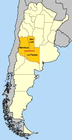
The parallel defines part of the border between Mendoza Province and La Pampa Province, and part of the border between San Luis Province and La Pampa Province 36°0′S 57°21′W / 36.000°S 57.350°W Atlantic Ocean
37th parallel south
The 37th parallel south is a circle of latitude that is 37 degrees south of the Earth's equatorial plane. It crosses the Atlantic Ocean, the Indian Ocean, Australasia, the Pacific Ocean and South America.
This parallel approximates that latitude at which solar irradiance equals the planetary average,[1] with higher insolation equatorward and lower poleward.
An exploration of the 37th parallel south is the theme of Jules Verne's novel In Search of the Castaways. The phantom reef of Maria Theresa Reef is supposed to lie on this parallel in the Pacific Ocean.
Around the world
Starting at the Prime Meridian and heading eastwards, the parallel 37° south passes through:
Coordinates Country, territory or ocean Notes 37°0′S 0°0′E / 37.000°S 0.000°E Atlantic Ocean 37°0′S 20°0′E / 37.000°S 20.000°E Indian Ocean Passing just north of Île Amsterdam. 37°0′S 139°42′E / 37.000°S 139.700°E AustraliaSouth Australia
Victoria
New South Wales37°0′S 149°56′E / 37.000°S 149.933°E Pacific Ocean Tasman Sea 37°0′S 174°28′E / 37.000°S 174.467°E New ZealandNorth Island – passing through Auckland just north of Auckland Airport (at 37°0′29″S 174°47′30″E / 37.00806°S 174.79167°E) 37°0′S 175°16′E / 37.000°S 175.267°E Pacific Ocean Hauraki Gulf 37°0′S 175°30′E / 37.000°S 175.500°E New ZealandCoromandel Peninsula, North Island – passing through Tairua 37°0′S 175°51′E / 37.000°S 175.850°E Pacific Ocean 37°0′S 73°33′W / 37.000°S 73.550°W ChileSanta María Island 37°0′S 73°31′W / 37.000°S 73.517°W Pacific Ocean 37°0′S 73°11′W / 37.000°S 73.183°W ChileBío Bío Region – passing through Coronel (at 37°0′S 73°10′W / 37.000°S 73.167°W) 37°0′S 71°9′W / 37.000°S 71.150°W ArgentinaNeuquén Province
Mendoza Province
La Pampa Province
Buenos Aires Province – passing through Pinamar (at 37°0′0″S 56°47′30″W / 37.00000°S 56.79167°W)37°0′S 56°45′W / 37.000°S 56.750°W Atlantic Ocean Passing just north of the island of Tristan da Cunha,  Saint Helena, Ascension and Tristan da Cunha
38th parallel south
The 38th parallel south is a circle of latitude that is 38 degrees south of the Earth's equatorial plane. It crosses the Atlantic Ocean, the Indian Ocean, Australia, New Zealand, the Pacific Ocean, and South America, including the Andes Mountains and Patagonia.
At this latitude the sun is visible for 14 hours, 48 minutes during the December solstice and 9 hours, 32 minutes during the June solstice.
Around the world
Starting at the Prime Meridian and heading eastwards, the parallel 38° south passes through:
Coordinates Country, territory or ocean Notes 38°0′S 0°0′E / 38.000°S 0.000°E Atlantic Ocean 38°0′S 20°0′E / 38.000°S 20.000°E Indian Ocean Passing just south of Île Amsterdam,  French Southern and Antarctic Lands
38°0′S 140°32′E / 38.000°S 140.533°E AustraliaSouth Australia
Victoria - passing through Port Phillip Bay and southeastern Melbourne38°0′S 147°42′E / 38.000°S 147.700°E Pacific Ocean Tasman Sea 38°0′S 174°47′E / 38.000°S 174.783°E New ZealandNorth Island - passing 2.4 km south of Whakatāne 38°0′S 178°21′E / 38.000°S 178.350°E Pacific Ocean 38°0′S 73°28′W / 38.000°S 73.467°W ChileBío Bío Region
Araucanía Region
Bío Bío Region38°0′S 71°5′W / 38.000°S 71.083°W ArgentinaNeuquén Province
Río Negro Province
La Pampa Province
Buenos Aires Province – passing through Mar del Plata (at 38°0′S 57°35′W / 38.000°S 57.583°W)38°0′S 57°33′W / 38.000°S 57.550°W Atlantic Ocean
39th parallel south
The 39th parallel south is a circle of latitude that is 39 degrees south of the Earth's equatorial plane. It crosses the Atlantic Ocean, the Indian Ocean, Australasia, the Pacific Ocean and South America.
Daylight along the 39th parallel south falls under 10 hours a day starting on 17 May and returns to over ten hours a day beginning 29 July. The growth of crops and other plants is considerably slowed during this period of reduced sunlight.
Around the world
Starting at the Prime Meridian and heading eastwards, the parallel 39° south passes through:
Coordinates Country, territory or ocean Notes 39°0′S 0°0′E / 39.000°S 0.000°E Atlantic Ocean 39°0′S 20°0′E / 39.000°S 20.000°E Indian Ocean Passing just south of Île Saint-Paul, French Southern and Antarctic Lands39°0′S 143°30′E / 39.000°S 143.500°E Indian Ocean Bass Strait 39°0′S 146°15′E / 39.000°S 146.250°E AustraliaVictoria - Wilsons Promontory 39°0′S 146°27′E / 39.000°S 146.450°E Pacific Ocean Tasman Sea 39°0′S 174°10′E / 39.000°S 174.167°E New ZealandTaranaki region – passing through Waitara
Manawatū-Whanganui region
Waikato region – passing just south of Tūrangi
Bay of Plenty region – for about 2 km (1.2 mi)
Hawke's Bay region39°0′S 177°53′E / 39.000°S 177.883°E Pacific Ocean 39°0′S 73°19′W / 39.000°S 73.317°W ChileAraucanía Region – passing through Teodoro Schmidt and Sollipulli Volcano 39°0′S 71°28′W / 39.000°S 71.467°W ArgentinaNeuquén Province
Río Negro Province – passing through General Roca (at 39°0′S 67°35′W / 39.000°S 67.583°W)
La Pampa Province
Buenos Aires Province – passing through Bahía Blanca (at 39°0′S 62°09′W / 39.000°S 62.150°W)39°0′S 62°0′W / 39.000°S 62.000°W Atlantic Ocean
40th parallel south
The 40th parallel south is a circle of latitude that is 40 degrees south of the Earth's equatorial plane. It crosses the Atlantic Ocean, the Indian Ocean, Oceania, the Pacific Ocean and South America. Its long oceanic stretches are the northern domain of the Roaring Forties.
On 21 June 2018, the sun is at 26.17° in the sky and at 73.83° on 21 December, in King Island, Tasmania, which is near the 40th parallel.[2][3]
The maximum altitude of the Sun is > 35.00º in April and > 28.00º in May.
40th parallel south also marks a line beyond which Andromeda constellation can no longer be observed.[4]
Around the world
Starting at the Prime Meridian and heading eastwards, the parallel 40° south passes through:
Coordinates Country, territory or ocean Notes 40°0′S 0°0′E / 40.000°S 0.000°E Atlantic Ocean 40°0′S 20°0′E / 40.000°S 20.000°E Indian Ocean 40°0′S 143°53′E / 40.000°S 143.883°E AustraliaKing Island, Tasmania 40°0′S 144°7′E / 40.000°S 144.117°E Indian Ocean Bass Strait 40°0′S 147°53′E / 40.000°S 147.883°E AustraliaFlinders Island, Tasmania 40°0′S 148°17′E / 40.000°S 148.283°E Pacific Ocean Tasman Sea 40°0′S 175°3′E / 40.000°S 175.050°E New ZealandManawatū-Whanganui region – passing just south of Whanganui
Hawke's Bay region – passing through Waipukurau40°0′S 176°54′E / 40.000°S 176.900°E Pacific Ocean 40°0′S 73°42′W / 40.000°S 73.700°W ChileLos Ríos Region – passing through Punta Galera and Pirihueico Lake 40°0′S 71°40′W / 40.000°S 71.667°W ArgentinaNeuquén Province
Río Negro Province
Buenos Aires Province40°0′S 62°20′W / 40.000°S 62.333°W Atlantic Ocean
See also
References
- ↑ See Nadeau, Alice and McGhee, Richard; ‘A simple formula for a planet’s mean annual insolation by latitude’; Icarus, volume 291, 15 July 2017, pp. 46-50
- ↑ "Sunrise and sunset times in King Island, June 2018". www.timeanddate.com. Retrieved 2018-04-29.
- ↑ "Sunrise and sunset times in King Island, December 2018". www.timeanddate.com. Retrieved 2018-04-29.
- ↑ "The Andromeda constellation: Facts, myth and location". Space.com. 2022-04-19. Retrieved 2024-10-07.
Circles of latitude / meridians | |
|---|---|
45x90
45x90
45x90
45x90
|