Circles of latitude between the 45th parallel south and the 50th parallel south
Following are circles of latitude between the 45th parallel south and the 50th parallel south:
46th parallel south
.svg.png)
The 46th parallel south is a circle of latitude that is 46 degrees south of the Earth's equatorial plane. It crosses the Atlantic Ocean, the Indian Ocean, Australasia, the Pacific Ocean and South America.
At this latitude the sun is visible for 15 hours, 45 minutes during the December solstice and 8 hours, 38 minutes during the June solstice.[1] This holds true regardless of longitude.
The largest city south of the 46th parallel is Punta Arenas.
Around the world
Starting at the Prime Meridian and heading eastwards, the parallel 46° south passes through:
Coordinates Country, territory or ocean Notes 46°0′S 0°0′E / 46.000°S 0.000°E Atlantic Ocean 46°0′S 20°0′E / 46.000°S 20.000°E Indian Ocean Passing between Île aux Cochons and Îlots des Apôtres in the Crozet Islands,  French Southern and Antarctic Lands
46°0′S 147°0′E / 46.000°S 147.000°E Pacific Ocean Tasman Sea 46°0′S 166°26′E / 46.000°S 166.433°E  New Zealand
Fiordland, passing through Lake Hauroko and Chalky Sound; Southland Region, close to the townships of Nightcaps and Mandeville; Otago Region, passing south of the city of Dunedin, close to the townships of Waitahuna and Henley 46°0′S 170°15′E / 46.000°S 170.250°E Pacific Ocean 46°0′S 75°2′W / 46.000°S 75.033°W  Chile
ChileTaitao Peninsula, Moraleda Channel, also passes near Balmaceda, Aysén Region 46°0′S 71°38′W / 46.000°S 71.633°W  Argentina
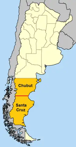
Border between Chubut Province and Santa Cruz Province
Passes near Comodoro Rivadavia, Chubut Province46°0′S 67°35′W / 46.000°S 67.583°W Atlantic Ocean
47th parallel south
The 47th parallel south is a circle of latitude that is 47 degrees south of the Earth's equatorial plane. It crosses the Atlantic Ocean, the Indian Ocean, Australasia, the Pacific Ocean and South America.
At this latitude, the sun is visible for 15 hours and 54 minutes during the December solstice and 8 hours and 30 minutes during the June solstice.[2] This holds true regardless of longitude.
Around the world
Starting at the Prime Meridian and heading eastwards, the parallel 47° south passes through:
Coordinates Country, territory or ocean Notes 47°0′S 0°0′E / 47.000°S 0.000°E Atlantic Ocean 47°0′S 20°0′E / 47.000°S 20.000°E Indian Ocean Passing just south of the Prince Edward Islands,  South Africa
47°0′S 147°0′E / 47.000°S 147.000°E Pacific Ocean Tasman Sea 47°0′S 167°42′E / 47.000°S 167.700°E New ZealandStewart Island 47°0′S 168°13′E / 47.000°S 168.217°E Pacific Ocean 47°0′S 74°3′W / 47.000°S 74.050°W ChileGulf of San Esteban and Northern Patagonian Ice Field, Aysén Region 47°0′S 71°52′W / 47.000°S 71.867°W ArgentinaSanta Cruz Province 47°0′S 66°48′W / 47.000°S 66.800°W Atlantic Ocean
48th parallel south
The 48th parallel south is a circle of latitude that is 48 degrees south of the Earth's equatorial plane. It crosses the Atlantic Ocean, the Indian Ocean, the Pacific Ocean and South America.
At this latitude the sun is visible for 16 hours, 3 minutes during the December solstice and 8 hours, 22 minutes during the June solstice.[3] If the latitude in the southern hemisphere is 48º50' or smaller, it is possible to view both astronomical dawn and dusk every day of the month of January. At the latitude of 48°33′38.58804” South, which is about 62.3 km (38.7 mi) south of this parallel, is the parallel where twilight/nighttime boundary on the December Solstice.
Around the world
Starting at the Prime Meridian and heading eastwards, the parallel 48° south passes through:
Coordinates Country, territory or ocean Notes 48°0′S 0°0′E / 48.000°S 0.000°E Atlantic Ocean 48°0′S 20°0′E / 48.000°S 20.000°E Indian Ocean 48°0′S 147°0′E / 48.000°S 147.000°E Pacific Ocean 48°0′S 75°18′W / 48.000°S 75.300°W ChileAysén Region 48°0′S 72°25′W / 48.000°S 72.417°W ArgentinaSanta Cruz Province 48°0′S 65°55′W / 48.000°S 65.917°W Atlantic Ocean
49th parallel south
The 49th parallel south is a circle of latitude that is 49 degrees south of the Earth's equatorial plane. It crosses the Atlantic Ocean, the Indian Ocean, the Pacific Ocean and South America.
At this latitude the sun is visible for 16 hours, 13 minutes during the December solstice and 8 hours, 14 minutes during the June solstice.[4]
Around the world
Starting at the Prime Meridian and heading eastwards, the parallel 49° south passes through:
Coordinates Country, territory or ocean Notes 49°0′S 0°0′E / 49.000°S 0.000°E Atlantic Ocean 49°0′S 20°0′E / 49.000°S 20.000°E Indian Ocean 49°0′S 68°48′E / 49.000°S 68.800°E French Southern and Antarctic LandsKerguelen Islands 49°0′S 69°36′E / 49.000°S 69.600°E Indian Ocean 49°0′S 147°0′E / 49.000°S 147.000°E Pacific Ocean Passing north of the Antipodes Islands, New Zealand49°0′S 75°35′W / 49.000°S 75.583°W ChileWellington Island, the English Narrows and mainland, Magallanes Region 49°0′S 72°59′W / 49.000°S 72.983°W ArgentinaSanta Cruz Province 49°0′S 67°31′W / 49.000°S 67.517°W Atlantic Ocean
50th parallel south
The 50th parallel south is a circle of latitude that is 50 degrees south of the Earth's equatorial plane. It crosses the Atlantic Ocean, the Indian Ocean, the Pacific Ocean and South America.
At this latitude the sun is visible for 16 hours, 23 minutes during the December solstice and 8 hours, 4 minutes during the June solstice.[5] On December 21, the sun is at 63.44 degrees in the sky and on June 21, the sun is at 16.56 degrees in the sky. During the summer solstice, nighttime does not get beyond astronomical twilight, a condition which lasts throughout the month of December. It is possible to view both astronomical dawn and dusk every day of the month of November.
The maximum altitude of the Sun is > 25.00º in April and > 18.00º in May.
The 50th parallel is the northerly boundary of the Dependencies of the Falkland Islands, the southerly boundary being the 60th parallel south.[6]
Around the world
Starting at the Prime Meridian and heading eastwards, the parallel 50° south passes through:
Coordinates Country, territory or ocean Notes 50°0′S 0°0′E / 50.000°S 0.000°E Atlantic Ocean 50°0′S 20°0′E / 50.000°S 20.000°E Indian Ocean Passing just south of the Kerguelen Islands, French Southern and Antarctic Lands50°0′S 147°0′E / 50.000°S 147.000°E Pacific Ocean Passing just south of the Antipodes Islands, New Zealand50°0′S 74°53′W / 50.000°S 74.883°W ChilePatagonic Archipelago and mainland, Magallanes Region 50°0′S 73°26′W / 50.000°S 73.433°W ArgentinaSanta Cruz Province 50°0′S 67°54′W / 50.000°S 67.900°W Atlantic Ocean
See also
References
- ↑ US Department of Commerce, NOAA. "ESRL Global Monitoring Laboratory - Global Radiation and Aerosols". gml.noaa.gov. Retrieved 2024-08-15.
- ↑ US Department of Commerce, NOAA. "ESRL Global Monitoring Laboratory - Global Radiation and Aerosols". gml.noaa.gov. Retrieved 2024-08-15.
- ↑ US Department of Commerce, NOAA. "ESRL Global Monitoring Laboratory - Global Radiation and Aerosols". gml.noaa.gov. Retrieved 2024-08-15.
- ↑ US Department of Commerce, NOAA. "ESRL Global Monitoring Laboratory - Global Radiation and Aerosols". gml.noaa.gov. Retrieved 2024-08-15.
- ↑ US Department of Commerce, NOAA. "ESRL Global Monitoring Laboratory - Global Radiation and Aerosols". gml.noaa.gov. Retrieved 2024-08-15.
- ↑ "The British Antarctic Territory Order In Council, 1962", Statutory Instruments, vol. South Atlantic Territories, no. 400, 1962
Circles of latitude / meridians | |
|---|---|
45x90
45x90
45x90
45x90
|