Circles of latitude between the 55th parallel south and the 80th parallel south
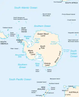
Following are circles of latitude between the 55th parallel south and the 80th parallel south. The 55th parallel south, crossing the southernmost point of Chile, is the last line of latitude moving southward to touch any part of any continent other than Antarctica, other than minor outlying islands.
56th parallel south
.svg.png)
The 56th parallel south is a circle of latitude that is 56 degrees south of the Earth's equatorial plane. No land lies on the parallel — it crosses nothing but ocean.
At this latitude the sun is visible for 17 hours, 37 minutes during the December solstice and 6 hours, 57 minutes during the June solstice.[1]
Around the world
Starting at the Prime Meridian and heading eastwards, the parallel 56° south passes through:
Coordinates Ocean Notes 56°0′S 0°0′E / 56.000°S 0.000°E Atlantic Ocean 56°0′S 20°0′E / 56.000°S 20.000°E Indian Ocean 56°0′S 147°0′E / 56.000°S 147.000°E Pacific Ocean Passing through the Drake Passage between South America and Antarctic Peninsula 56°0′S 67°17′W / 56.000°S 67.283°W Pacific Ocean Passing approximately 2 kilometers south of Hornos Island (Cape Horn),  Chile
Chile56°0′S 67°16′W / 56.000°S 67.267°W Atlantic Ocean Running through the Scotia Sea. 56°0′S 36°6′W / 56.000°S 36.100°W Atlantic Ocean Passing approximately 122 kilometers south of South Georgia,  South Georgia and the South Sandwich Islands (claimed by
  Argentina).
57th parallel south
The 57th parallel south is a circle of latitude that is 57 degrees south of the Earth's equatorial plane. No land lies on the parallel — it crosses nothing but ocean.
At this latitude the sun is visible for 17 hours, 53 minutes during the December solstice and 6 hours, 43 minutes during the June solstice. On December 21, the sun is at 56.44 degrees in the sky and on June 21, the sun is at 9.56 degrees in the sky. During the summer solstice, nighttime does not get beyond nautical twilight, a condition which lasts throughout the month of December. It is possible to view both astronomical dawn and dusk every day of the month of October.[2]
The maximum altitude of the Sun is > 18.00º in April and > 11.00º in May.
Around the world
Starting at the Prime Meridian and heading eastwards, the parallel 57° south passes through:
Coordinates Ocean Notes 57°0′S 0°0′E / 57.000°S 0.000°E Atlantic Ocean 57°0′S 20°0′E / 57.000°S 20.000°E Indian Ocean 57°0′S 147°0′E / 57.000°S 147.000°E Pacific Ocean Passing through the Drake Passage between South America and the Antarctic Peninsula 57°0′S 67°16′W / 57.000°S 67.267°W[3] Atlantic Ocean Running through the Scotia Sea, passing 8 kilometers north of Vindication Island and Candlemas Island, South Georgia and the South Sandwich Islands (claimed by Argentina)
58th parallel south
The 58th parallel south is a circle of latitude that is 58 degrees south of the Earth's equatorial plane. No land lies on the parallel — it crosses nothing but ocean.
At this latitude the sun is visible for 18 hours, 11 minutes during the December solstice and 6 hours, 27 minutes during the June solstice.[4]
Around the world
Starting at the Prime Meridian and heading eastwards, the parallel 58° south passes through:
Coordinates Ocean Notes 58°0′S 0°0′E / 58.000°S 0.000°E Atlantic Ocean 58°0′S 20°0′E / 58.000°S 20.000°E Indian Ocean 58°0′S 147°0′E / 58.000°S 147.000°E Pacific Ocean Passing through the Drake Passage between South America and the Antarctic Peninsula 58°0′S 67°16′W / 58.000°S 67.267°W Atlantic Ocean Running through the Scotia Sea, passing between Saunders Island and Montagu Island, South Georgia and the South Sandwich Islands (claimed by Argentina)
59th parallel south
The 59th parallel south is a circle of latitude that is 59 degrees south of the Earth's equatorial plane. The only landmass on this parallel is Bristol Island.[a]
At this latitude the sun is visible for 18 hours, 30 minutes during the December solstice and 6 hours, 10 minutes during the June solstice.[5]
Around the world
Starting at the Prime Meridian and heading eastwards, the parallel 59° south passes through:
Coordinates Territory or ocean Notes 59°0′S 0°0′E / 59.000°S 0.000°E Atlantic Ocean 59°0′S 20°0′E / 59.000°S 20.000°E Indian Ocean 59°0′S 147°0′E / 59.000°S 147.000°E Pacific Ocean Passing through the Drake Passage between South America and the Antarctic Peninsula 59°0′S 67°16′W / 59.000°S 67.267°W Atlantic Ocean Running through the Scotia Sea 59°0′S 26°37′W / 59.000°S 26.617°W South Georgia and the South Sandwich IslandsBristol Island (claimed by Argentina)59°0′S 26°35′W / 59.000°S 26.583°W Atlantic Ocean
60th parallel south
The 60th parallel south is a circle of latitude that is 60 degrees south of Earth's equatorial plane. No land lies on the parallel—it crosses nothing but ocean. The closest land is a group of rocks north of Coronation Island (Melson Rocks or Governor Islands) of the South Orkney Islands, which are about 54 km south of the parallel, and Thule Island and Cook Island of the South Sandwich Islands, which both are about 57 km north of the parallel (with Cook Island slightly closer).[6]
The parallel marks the northern limit of the Southern Ocean (though some organisations and countries, notably Australia, have other definitions) and of the Antarctic Treaty System. It also marks the southern boundary of the South Pacific Nuclear-Weapon-Free Zone and the Latin American Nuclear-Weapon-Free Zone.
At this latitude the sun is visible for 18 hours, 52 minutes during the December solstice and 5 hours, 52 minutes during the June solstice. On December 21, the sun is at 53.44 degrees up in the sky and 6.56 degrees on June 21. The sun's altitude is exactly 30 degrees at either equinox.
The latitudes south of this parallel are often referred to as the Screaming 60s due to the prevailing high-speed, westerly winds which can generate large waves in excess of 15 m (50 ft) and peak wind speeds over 145 km/h (90 mph).[7]
The maximum altitude of the Sun is > 15.00º in April and > 8.00º in May.
The lowest latitude where white nights can be observed is approximately on this parallel.
During the summer solstice, nighttime does not get beyond nautical twilight, a condition which lasts throughout the month of December. It is possible to view both astronomical dawn and dusk every day between February 17 and October 24.
Around the world
Starting at the prime meridian and heading eastwards, the parallel 60° south passes through:
Coordinates Ocean Notes 60°0′S 0°0′E / 60.000°S 0.000°E The Prime Meridian 60°0′S 20°0′E / 60.000°S 20.000°E the boundary of the Atlantic and Indian Oceans 60°0′S 147°0′E / 60.000°S 147.000°E the boundary of the Indian and Pacific Oceans Additionally passes through the Pacific Ocean at the Drake Passage between South America and the Antarctic Peninsula 60°0′S 67°16′W / 60.000°S 67.267°W the boundary of the Pacific and Atlantic Oceans Running close to the southern border of the Scotia Sea and the South Orkney Islands, South Georgia and the South Sandwich Islands (claimed by Argentina)
61st parallel south
The 61st parallel south is a circle of latitude that is 61 degrees south of the Earth's equatorial plane. No land lies on the parallel—it crosses nothing but the Southern Ocean.
At this latitude the sun is visible for 19 hours, 16 minutes during the December solstice and 5 hours, 32 minutes during the June solstice.[8] On the December solstice, the sun's altitude is 52.44 degrees and on the June solstice, it is 5.56 degrees.
The lowest latitude where civil twilight can last all night lies approximately on this parallel.
Around the world
Starting at the Prime Meridian and heading eastwards, the parallel 61° south passes through:
Coordinates Ocean Notes 61°0′S 0°0′E / 61.000°S 0.000°E Southern Ocean South of the Atlantic Ocean 61°0′S 20°0′E / 61.000°S 20.000°E South of the Indian Ocean 61°0′S 147°0′E / 61.000°S 147.000°E South of the Pacific Ocean
Passing through the Drake Passage between South America and the Antarctic Peninsula61°0′S 67°16′W / 61.000°S 67.267°W South of the Atlantic Ocean
Passing just north of Elephant Island, and Clarence Island (claimed by Argentina, Chile and  United Kingdom)
Passing just south of the South Orkney Islands, South Georgia and the South Sandwich Islands (claimed by Argentina)
62nd parallel south
The 62nd parallel south is a circle of latitude that is 62 degrees south of the Earth's equatorial plane. It crosses the Southern Ocean and Antarctica.
At this latitude the sun is visible for 19 hours, 45 minutes during the December solstice and 5 hours, 9 minutes during the June solstice.[9]
Around the world
Starting at the Prime Meridian and heading eastwards, the parallel 62° south passes through:
Coordinates Continent or ocean Notes 62°0′S 0°0′E / 62.000°S 0.000°E Southern Ocean South of the Atlantic Ocean 62°0′S 20°0′E / 62.000°S 20.000°E South of the Indian Ocean 62°0′S 147°0′E / 62.000°S 147.000°E South of the Pacific Ocean
Passing through the Drake Passage between South America and the Antarctic Peninsula62°0′S 67°16′W / 62.000°S 67.267°W South of the Atlantic Ocean 62°0′S 58°36′W / 62.000°S 58.600°W Antarctica King George Island, claimed by Argentina, Chile and United Kingdom62°0′S 57°39′W / 62.000°S 57.650°W Southern Ocean South of the Atlantic Ocean
63rd parallel south
The 63rd parallel south is a circle of latitude that is 63 degrees south of the Earth's equatorial plane. It crosses the Southern Ocean and Antarctica.
At this latitude the sun is visible for 20 hours, 19 minutes during the December solstice and 4 hours, 42 minutes during the June solstice. If the latitude in the southern hemisphere is 63º26' or smaller, it is possible to view both astronomical dawn and dusk every day of the month of March.[10]
Around the world
Starting at the Prime Meridian and heading eastwards, the parallel 63° south passes through:
Coordinates Continent or ocean Notes 63°0′S 0°0′E / 63.000°S 0.000°E Southern Ocean South of the Atlantic Ocean 63°0′S 20°0′E / 63.000°S 20.000°E South of the Indian Ocean 63°0′S 147°0′E / 63.000°S 147.000°E South of the Pacific Ocean 63°0′S 67°16′W / 63.000°S 67.267°W South of the Atlantic Ocean 63°0′S 62°36′W / 63.000°S 62.600°W Antarctica Smith Island, claimed by Argentina, Chile and United Kingdom63°0′S 62°28′W / 63.000°S 62.467°W Southern Ocean South of the Atlantic Ocean 63°0′S 60°42′W / 63.000°S 60.700°W Antarctica Deception Island, claimed by Argentina, Chile and United Kingdom63°0′S 60°33′W / 63.000°S 60.550°W Southern Ocean South of the Atlantic Ocean, passing 24 km north of Prime Head, Antarctic Peninsula 63°0′S 56°30′W / 63.000°S 56.500°W Antarctica D'Urville Island, claimed by Argentina, Chile and United Kingdom63°0′S 56°8′W / 63.000°S 56.133°W Southern Ocean South of the Atlantic Ocean
64th parallel south
The 64th parallel south is a circle of latitude that is 64 degrees south of the Earth's equatorial plane. It crosses the Southern Ocean and the Antarctic mainland, the latter as the most northern latitude.
At this latitude the sun is visible for 21 hours, 1 minute during the December solstice and 4 hours, 12 minutes during the June solstice.[11]
Around the world
Starting at the Prime Meridian and heading eastwards, the parallel 64° south passes through:
Coordinates Continent or ocean Notes 64°0′S 0°0′E / 64.000°S 0.000°E Southern Ocean South of the Atlantic Ocean 64°0′S 20°0′E / 64.000°S 20.000°E South of the Indian Ocean 64°0′S 147°0′E / 64.000°S 147.000°E South of the Pacific Ocean 64°0′S 67°16′W / 64.000°S 67.267°W South of the Atlantic Ocean
Passing just north of Brabant Island, Antarctica64°0′S 60°35′W / 64.000°S 60.583°W Antarctica Antarctic Peninsula and James Ross Island, claimed by Argentina, Chile and United Kingdom64°0′S 57°31′W / 64.000°S 57.517°W Southern Ocean South of the Atlantic Ocean
65th parallel south
The 65th parallel south is a circle of latitude that is 65 degrees south of the Earth's equatorial plane. It crosses the Southern Ocean and Antarctica.
At this latitude the sun is visible for 22 hours, 2 minutes during the December solstice and 3 hours, 35 minutes during the June solstice.[12]
Around the world
Starting at the Prime Meridian and heading eastwards, the parallel 65° south passes through:
Coordinates Continent or ocean Notes 65°0′S 0°0′E / 65.000°S 0.000°E Southern Ocean South of the Atlantic Ocean 65°0′S 20°0′E / 65.000°S 20.000°E South of the Indian Ocean 65°0′S 147°0′E / 65.000°S 147.000°E South of the Pacific Ocean 65°0′S 67°16′W / 65.000°S 67.267°W South of the Atlantic Ocean 65°0′S 63°12′W / 65.000°S 63.200°W Antarctica Antarctic Peninsula, claimed by Argentina, Chile and United Kingdom65°0′S 59°3′W / 65.000°S 59.050°W Southern Ocean South of the Atlantic Ocean
66th parallel south
The 66th parallel south is a circle of latitude that is 66 degrees south of the Earth's equatorial plane, about 61 km north of the Antarctic Circle. It crosses the Southern Ocean and Antarctica.
This latitude also roughly corresponds to the minimum latitude in which midnight sun can last all night near the summer solstice.
At this latitude the sun rises on December 13 and does not set again until December 30.[13]
Around the world
Starting at the Prime Meridian and heading eastwards, the parallel 66° south passes through:
67th parallel south
The 67th parallel south is a circle of latitude that is 67 degrees south of the Earth's equatorial plane, about 50 km south of the Antarctic Circle. It crosses the Southern Ocean and Antarctica.
At this latitude the sun is visible for 24 hours, 0 minutes during the December solstice (Summer solstice) and 1 hour, 29 minutes during the June solstice (Winter solstice). If the latitude in the southern hemisphere is 67°45′ or smaller, every day of the month of September can view both astronomical dawn and astronomical dusk.
Around the world
Starting at the Prime Meridian and heading eastwards, the parallel 67° south passes through:
68th parallel south
The 68th parallel south is a circle of latitude that is 68 degrees south of the Earth's equatorial plane, in the Antarctic. It crosses the Southern Ocean and Antarctica. At this latitude, the sun is visible for 24 hours, 0 minutes during the December Solstice, and civil twilight during the June Solstice.
Around the world
Starting at the Prime Meridian and heading eastwards, the parallel 68° south passes through:
Coordinates Continent or ocean Notes 68°0′S 0°0′E / 68.000°S 0.000°E Southern Ocean King Haakon VII Sea, south of the Atlantic Ocean 68°0′S 44°3′E / 68.000°S 44.050°E Antarctica Queen Maud Land, claimed by  Norway
68°0′S 45°0′E / 68.000°S 45.000°E Enderby Land, Kemp Land, Mac. Robertson Land, claimed by .svg.png) Australia
Australia68°0′S 70°45′E / 68.000°S 70.750°E Southern Ocean Prydz Bay, Cooperation Sea, south of the Indian Ocean 68°0′S 80°3′E / 68.000°S 80.050°E Antarctica Princess Elizabeth Land, Wilhelm II Land, Queen Mary Land, Wilkes Land, claimed by Australia68°0′S 136°0′E / 68.000°S 136.000°E Adélie Land, claimed by  France
68°0′S 142°0′E / 68.000°S 142.000°E George V Land, claimed by Australia68°0′S 148°31′E / 68.000°S 148.517°E Southern Ocean South of the Pacific Ocean 68°0′S 67°13′W / 68.000°S 67.217°W Antarctica Alexander Island and Antarctic Peninsula, claimed by Argentina, Chile and United Kingdom (overlapping claims)68°0′S 60°6′W / 68.000°S 60.100°W Southern Ocean Weddell Sea, south of the Atlantic Ocean
69th parallel south
The 69th parallel south is a circle of latitude that is 69 degrees south of the Earth's equatorial plane, in the Antarctic. It crosses the Southern Ocean and Antarctica.
Around the world
Starting at the Prime Meridian and heading eastwards, the parallel 69° south passes through:
Coordinates Continent or ocean Notes 69°0′S 0°0′E / 69.000°S 0.000°E Southern Ocean King Haakon VII Sea, south of the Atlantic Ocean 69°0′S 32°30′E / 69.000°S 32.500°E Antarctica Queen Maud Land, claimed by Norway69°0′S 35°4′E / 69.000°S 35.067°E Southern Ocean Lützow-Holm Bay, King Haakon VII Sea, south of the Indian Ocean 69°0′S 39°46′E / 69.000°S 39.767°E Antarctica Queen Maud Land, claimed by Norway69°0′S 45°0′E / 69.000°S 45.000°E Enderby Land, Kemp Land, Mac. Robertson Land, claimed by Australia69°0′S 74°55′E / 69.000°S 74.917°E Southern Ocean Prydz Bay, Cooperation Sea, south of the Indian Ocean 69°0′S 78°10′E / 69.000°S 78.167°E Antarctica Princess Elizabeth Land, Wilhelm II Land, Queen Mary Land, Wilkes Land, claimed by Australia69°0′S 136°0′E / 69.000°S 136.000°E Adélie Land, claimed by France69°0′S 142°0′E / 69.000°S 142.000°E George V Land, claimed by Australia69°0′S 156°0′E / 69.000°S 156.000°E Southern Ocean South of the Pacific Ocean
Passing south of Peter I Island69°0′S 71°47′W / 69.000°S 71.783°W Antarctica Alexander Island and Antarctic Peninsula - claimed by Argentina, Chile and United Kingdom (overlapping claims)69°0′S 70°5′W / 69.000°S 70.083°W Southern Ocean Marguerite Bay, Bellingshausen Sea, south of the Drake Passage 69°0′S 67°34′W / 69.000°S 67.567°W Antarctica Antarctic Peninsula, claimed by Argentina, Chile and United Kingdom69°0′S 60°33′W / 69.000°S 60.550°W Southern Ocean Weddell Sea, south of the Atlantic Ocean 69°0′S 1°23′W / 69.000°S 1.383°W Antarctica Queen Maud Land, claimed by Norway
70th parallel south
The 70th parallel south is a circle of latitude that is 70 degrees south of the Earth's equatorial plane in the Antarctic. The parallel passes through the Southern Ocean and Antarctica.
Around the world
Starting at the Prime Meridian and heading eastwards, the parallel 70° south passes through:
71st parallel south
The 71st parallel south is a circle of latitude that is 71 degrees south of the Earth's equatorial plane in the Antarctic. The parallel passes through the Southern Ocean and Antarctica.
Around the world
Starting at the Prime Meridian and heading eastwards, the parallel 71° south passes through:
Coordinates Continent or ocean Notes 71°0′S 0°0′E / 71.000°S 0.000°E Antarctica Queen Maud Land, claimed by Norway71°0′S 45°0′E / 71.000°S 45.000°E Western Australian Antarctic Territory, claimed by Australia71°0′S 136°0′E / 71.000°S 136.000°E Adélie Land, claimed by France71°0′S 142°0′E / 71.000°S 142.000°E Eastern Australian Antarctic Territory, claimed by Australia71°0′S 160°0′E / 71.000°S 160.000°E Ross Dependency, claimed by  New Zealand
71°0′S 167°47′E / 71.000°S 167.783°E Southern Ocean South of the Pacific Ocean 71°0′S 73°18′W / 71.000°S 73.300°W Antarctica Alexander Island and Antarctic Peninsula - claimed by Argentina, Chile and United Kingdom (overlapping claims)71°0′S 60°24′W / 71.000°S 60.400°W Southern Ocean Weddell Sea, south of the Atlantic Ocean 71°0′S 10°59′W / 71.000°S 10.983°W Antarctica Queen Maud Land, claimed by Norway
72nd parallel south
The 72nd parallel south is a circle of latitude that is 72 degrees south of the Earth's equatorial plane in the Antarctic. The parallel passes through the Southern Ocean and Antarctica.
This is the parallel where twilight/nighttime boundary on the equinoxes.
This is also the lowest parallel that golden hour occurs even at midnight sun, because the Sun is less than 6°00'00" above the horizon. Midnight sun without golden hour occurs at latitudes greater than 72°33'38.58804", i.e., about 666.8 km (414.3 mi) south of the Antarctic Circle in the case of the December Solstice.
Around the world
Starting at the Prime Meridian and heading eastwards, the parallel 72° south passes through:
Coordinates Continent or ocean Notes 72°0′S 0°0′E / 72.000°S 0.000°E Antarctica Queen Maud Land, claimed by Norway72°0′S 45°0′E / 72.000°S 45.000°E Western Australian Antarctic Territory, claimed by Australia72°0′S 136°0′E / 72.000°S 136.000°E Adélie Land, claimed by France72°0′S 142°0′E / 72.000°S 142.000°E Eastern Australian Antarctic Territory, claimed by Australia72°0′S 160°0′E / 72.000°S 160.000°E Ross Dependency, claimed by New Zealand72°0′S 170°38′E / 72.000°S 170.633°E Southern Ocean Ross Sea, south of the Pacific Ocean 72°0′S 102°15′W / 72.000°S 102.250°W Antarctica Thurston Island, off coast Ellsworth Land, unclaimed territory 72°0′S 95°36′W / 72.000°S 95.600°W Southern Ocean Bellingshausen Sea, south of the Pacific Ocean 72°0′S 74°21′W / 72.000°S 74.350°W Antarctica Alexander Island and Antarctic Peninsula - claimed by Argentina, Chile and United Kingdom (overlapping claims)72°0′S 60°5′W / 72.000°S 60.083°W Southern Ocean Weddell Sea, south of the Atlantic Ocean 72°0′S 14°33′W / 72.000°S 14.550°W Antarctica Queen Maud Land, claimed by Norway
73rd parallel south
The 73rd parallel south is a circle of latitude that is 73 degrees south of the Earth's equatorial plane in the Antarctic. The parallel passes through the Southern Ocean and Antarctica.
Around the world
Starting at the Prime Meridian and heading eastwards, the parallel 73° south passes through:
74th parallel south
The 74th parallel south is a circle of latitude that is 74 degrees south of the Earth's equatorial plane in the Antarctic. The parallel passes through the Southern Ocean and Antarctica.
Around the world
Starting at the Prime Meridian and heading eastwards, the parallel 74° south passes through:
Coordinates Continent or ocean Notes 74°0′S 0°0′E / 74.000°S 0.000°E Antarctica Queen Maud Land, claimed by Norway74°0′S 45°0′E / 74.000°S 45.000°E Western Australian Antarctic Territory, claimed by Australia74°0′S 136°0′E / 74.000°S 136.000°E Adélie Land, claimed by France74°0′S 142°0′E / 74.000°S 142.000°E Eastern Australian Antarctic Territory, claimed by Australia74°0′S 160°0′E / 74.000°S 160.000°E Ross Dependency, claimed by New Zealand74°0′S 166°2′E / 74.000°S 166.033°E Southern Ocean Ross Sea, south of the Pacific Ocean 74°0′S 127°24′W / 74.000°S 127.400°W Antarctica Marie Byrd Land, Unclaimed territory 74°0′S 113°34′E / 74.000°S 113.567°E Southern Ocean Amundsen Sea, south of the Pacific Ocean 74°0′S 109°20′W / 74.000°S 109.333°W Antarctica Marie Byrd Land, Unclaimed territory 74°0′S 107°49′E / 74.000°S 107.817°E Southern Ocean Amundsen Sea, south of the Pacific Ocean 74°0′S 102°19′W / 74.000°S 102.317°W Antarctica Marie Byrd Land, Unclaimed territory 74°0′S 90°0′W / 74.000°S 90.000°W Antártica Chilena, claimed by Chile74°0′S 80°0′W / 74.000°S 80.000°W Territory claimed by Chile and United Kingdom (overlapping claims)74°0′S 74°0′W / 74.000°S 74.000°W Territory claimed by Argentina, Chile and United Kingdom (overlapping claims)74°0′S 53°0′W / 74.000°S 53.000°W Territory claimed by Argentina and United Kingdom (overlapping claims)74°0′S 60°50′W / 74.000°S 60.833°W Southern Ocean Weddell Sea, south of the Atlantic Ocean 74°0′S 21°13′W / 74.000°S 21.217°W Antarctica British Antarctic Territory, claimed by United Kingdom74°0′S 20°0′W / 74.000°S 20.000°W Queen Maud Land, claimed by Norway
75th parallel south
The 75th parallel south is a circle of latitude that is 75 degrees south of the Earth's equatorial plane in the Antarctic. It passes through the Southern Ocean and Antarctica.
Around the world
Starting at the Prime Meridian and heading eastwards, the parallel 75° south passes through:
Coordinates Continent or ocean Notes 75°0′S 0°0′E / 75.000°S 0.000°E Antarctica Queen Maud Land, claimed by Norway75°0′S 45°0′E / 75.000°S 45.000°E Western Australian Antarctic Territory, claimed by Australia75°0′S 136°0′E / 75.000°S 136.000°E Adélie Land, claimed by France75°0′S 142°0′E / 75.000°S 142.000°E Eastern Australian Antarctic Territory, claimed by Australia75°0′S 160°0′E / 75.000°S 160.000°E Ross Dependency, claimed by New Zealand75°0′S 163°39′E / 75.000°S 163.650°E Southern Ocean Ross Sea, south of the Pacific Ocean 75°0′S 137°0′W / 75.000°S 137.000°W Antarctica Ross Dependency, claimed by New Zealand75°0′S 150°0′W / 75.000°S 150.000°W Marie Byrd Land, Unclaimed territory 75°0′S 90°0′W / 75.000°S 90.000°W Antártica Chilena, claimed by Chile75°0′S 80°0′W / 75.000°S 80.000°W Territory claimed by Chile and United Kingdom (overlapping claims)75°0′S 74°0′W / 75.000°S 74.000°W Territory claimed by Argentina, Chile and United Kingdom (overlapping claims)75°0′S 53°0′W / 75.000°S 53.000°W Territory claimed by Argentina and United Kingdom (overlapping claims)75°0′S 61°32′W / 75.000°S 61.533°W Southern Ocean Weddell Sea, south of the Atlantic Ocean 75°0′S 24°12′W / 75.000°S 24.200°W Antarctica British Antarctic Territory, claimed by United Kingdom75°0′S 20°0′W / 75.000°S 20.000°W Queen Maud Land, claimed by Norway
76th parallel south
The 76th parallel south is a circle of latitude that is 76 degrees south of the Earth's equatorial plane in the Antarctic. The parallel passes through the Southern Ocean and Antarctica.
Around the world
Starting at the Prime Meridian and heading eastwards, the parallel 76° south passes through:
Coordinates Continent or ocean Notes 76°0′S 0°0′E / 76.000°S 0.000°E Antarctica Queen Maud Land, claimed by Norway76°0′S 45°0′E / 76.000°S 45.000°E Western Australian Antarctic Territory, claimed by Australia76°0′S 136°0′E / 76.000°S 136.000°E Adélie Land, claimed by France76°0′S 142°0′E / 76.000°S 142.000°E Eastern Australian Antarctic Territory, claimed by Australia76°0′S 160°0′E / 76.000°S 160.000°E Ross Dependency, claimed by New Zealand76°0′S 162°35′E / 76.000°S 162.583°E Southern Ocean Ross Sea, south of the Pacific Ocean 76°0′S 148°5′W / 76.000°S 148.083°W Antarctica Ross Dependency, claimed by New Zealand76°0′S 150°0′W / 76.000°S 150.000°W Marie Byrd Land, Unclaimed territory 76°0′S 90°0′W / 76.000°S 90.000°W Antártica Chilena, claimed by Chile76°0′S 80°0′W / 76.000°S 80.000°W Territory claimed by Chile and United Kingdom (overlapping claims)76°0′S 74°0′W / 76.000°S 74.000°W Territory claimed by Argentina, Chile and United Kingdom (overlapping claims)76°0′S 53°0′W / 76.000°S 53.000°W Territory claimed by Argentina and United Kingdom (overlapping claims)76°0′S 56°54′W / 76.000°S 56.900°W Southern Ocean Weddell Sea, south of the Atlantic Ocean 76°0′S 27°0′W / 76.000°S 27.000°W Antarctica Territory claimed by Argentina and United Kingdom (overlapping claims)76°0′S 25°0′W / 76.000°S 25.000°W British Antarctic Territory, claimed by United Kingdom76°0′S 20°0′W / 76.000°S 20.000°W Queen Maud Land, claimed by Norway
77th parallel south
The 77th parallel south is a circle of latitude that is 77 degrees south of the Earth's equatorial plane in the Antarctic. The parallel passes through the Southern Ocean and Antarctica.
Around the world
Starting at the Prime Meridian and heading eastwards, the parallel 77° south passes through:
Coordinates Continent or ocean Notes 77°0′S 0°0′E / 77.000°S 0.000°E Antarctica Queen Maud Land, claimed by Norway77°0′S 45°0′E / 77.000°S 45.000°E Western Australian Antarctic Territory, claimed by Australia77°0′S 136°0′E / 77.000°S 136.000°E Adélie Land, claimed by France77°0′S 142°0′E / 77.000°S 142.000°E Eastern Australian Antarctic Territory, claimed by Australia77°0′S 160°0′E / 77.000°S 160.000°E Ross Dependency, claimed by New Zealand77°0′S 151°22′E / 77.000°S 151.367°E Southern Ocean Ross Sea, south of the Pacific Ocean 77°0′S 148°5′W / 77.000°S 148.083°W Antarctica Ross Dependency, claimed by New Zealand77°0′S 150°0′W / 77.000°S 150.000°W Marie Byrd Land, Unclaimed territory 77°0′S 90°0′W / 77.000°S 90.000°W Antártica Chilena, claimed by Chile77°0′S 80°0′W / 77.000°S 80.000°W Territory claimed by Chile and United Kingdom (overlapping claims)77°0′S 74°0′W / 77.000°S 74.000°W Territory claimed by Argentina, Chile and United Kingdom (overlapping claims)77°0′S 53°0′W / 77.000°S 53.000°W Territory claimed by Argentina and United Kingdom (overlapping claims)77°0′S 51°6′W / 77.000°S 51.100°W Southern Ocean Weddell Sea, south of the Atlantic Ocean 77°0′S 31°27′W / 77.000°S 31.450°W Antarctica Territory claimed by Argentina and United Kingdom (overlapping claims)77°0′S 25°0′W / 77.000°S 25.000°W British Antarctic Territory, claimed by United Kingdom77°0′S 20°0′W / 77.000°S 20.000°W Queen Maud Land, claimed by Norway
78th parallel south
The 78th parallel south is a circle of latitude that is 78 degrees south of the Earth's equatorial plane in the Antarctic. The parallel passes through the Southern Ocean and Antarctica.
Around the world
Starting at the Prime Meridian and heading eastwards, the parallel 78° south passes through:
Coordinates Continent or ocean Notes 78°0′S 0°0′E / 78.000°S 0.000°E Antarctica Queen Maud Land, claimed by Norway78°0′S 45°0′E / 78.000°S 45.000°E Western Australian Antarctic Territory, claimed by Australia78°0′S 136°0′E / 78.000°S 136.000°E Adélie Land, claimed by France78°0′S 142°0′E / 78.000°S 142.000°E Eastern Australian Antarctic Territory, claimed by Australia78°0′S 160°0′E / 78.000°S 160.000°E Ross Dependency, claimed by New Zealand78°0′S 177°42′E / 78.000°S 177.700°E Southern Ocean Ross Sea, south of the Pacific Ocean 78°0′S 160°26′W / 78.000°S 160.433°W Antarctica Ross Dependency, claimed by New Zealand78°0′S 150°0′W / 78.000°S 150.000°W Marie Byrd Land, Unclaimed territory 78°0′S 90°0′W / 78.000°S 90.000°W Antártica Chilena, claimed by Chile78°0′S 80°0′W / 78.000°S 80.000°W Territory claimed by Chile and United Kingdom (overlapping claims)78°0′S 74°0′W / 78.000°S 74.000°W Territory claimed by Argentina, Chile and United Kingdom (overlapping claims)78°0′S 53°0′W / 78.000°S 53.000°W Territory claimed by Argentina and United Kingdom (overlapping claims)78°0′S 45°44′W / 78.000°S 45.733°W Southern Ocean Weddell Sea, south of the Atlantic Ocean 78°0′S 42°7′W / 78.000°S 42.117°W Antarctica Territory claimed by Argentina and United Kingdom (overlapping claims)78°0′S 25°0′W / 78.000°S 25.000°W British Antarctic Territory, claimed by United Kingdom78°0′S 20°0′W / 78.000°S 20.000°W Queen Maud Land, claimed by Norway
79th parallel south
The 79th parallel south is a circle of latitude that is 79 degrees south of the Earth's equatorial plane in the Antarctic.
The parallel passes only through Antarctica and Antarctic ice shelves.
Around the world
Starting at the Prime Meridian and heading eastwards, the parallel 79° south passes through:
Coordinates Continent Notes 79°0′S 0°0′E / 79.000°S 0.000°E Antarctica Queen Maud Land, claimed by Norway79°0′S 45°0′E / 79.000°S 45.000°E Western Australian Antarctic Territory, claimed by Australia79°0′S 136°0′E / 79.000°S 136.000°E Adélie Land, claimed by France79°0′S 142°0′E / 79.000°S 142.000°E Eastern Australian Antarctic Territory, claimed by Australia79°0′S 160°0′E / 79.000°S 160.000°E Ross Dependency, claimed by New Zealand79°0′S 150°0′W / 79.000°S 150.000°W Marie Byrd Land, Unclaimed territory 79°0′S 90°0′W / 79.000°S 90.000°W Antártica Chilena, claimed by Chile79°0′S 80°0′W / 79.000°S 80.000°W Territory claimed by Chile and United Kingdom (overlapping claims)79°0′S 74°0′W / 79.000°S 74.000°W Territory claimed by Argentina, Chile and United Kingdom (overlapping claims)79°0′S 53°0′W / 79.000°S 53.000°W Territory claimed by Argentina and United Kingdom (overlapping claims)79°0′S 25°0′W / 79.000°S 25.000°W British Antarctic Territory, claimed by United Kingdom79°0′S 20°0′W / 79.000°S 20.000°W Queen Maud Land, claimed by Norway
80th parallel south
The 80th parallel south is a circle of latitude that is 80 degrees south of the Earth's equatorial plane, and 10 degrees (690 miles/1100 kilometers) north of the United States Amundsen-Scott South Pole Station. Regions south of this latitude are excluded from UTM zones.
This line of latitude passes only through Antarctica and Antarctic ice shelves.
Around the world
Starting at the Prime Meridian and heading eastwards, the parallel 80° south passes through:
Coordinates Continent Sub-continent Local area Claimed by 80°0′S 0°0′E / 80.000°S 0.000°E Antarctica West Antarctica Part of Queen Maud Land Norway80°0′S 45°0′E / 80.000°S 45.000°E Enderby Land, Kemp Land, Mac. Robertson Land, Princess Elizabeth Land, Kaiser Wilhelm II Land, Queen Mary Land, Wilkes Land, aka Western Australian Antarctic Territory Australia80°0′S 136°0′E / 80.000°S 136.000°E Adélie Land France80°0′S 142°0′E / 80.000°S 142.000°E George V Land, Oates Land, Victoria Land, aka Eastern Australian Antarctic Territory Australia80°0′S 160°0′E / 80.000°S 160.000°E Ross Dependency New Zealand80°0′S 150°0′W / 80.000°S 150.000°W East Antarctica Marie Byrd Land
Ellsworth LandUnclaimed territory 80°0′S 90°0′W / 80.000°S 90.000°W Ellsworth Land, in parts Antártica Chilena Chile80°0′S 80°0′W / 80.000°S 80.000°W Ellsworth Land Chile and United Kingdom (overlapping claims)80°0′S 74°0′W / 80.000°S 74.000°W Antarctic Peninsula Argentina, Chile and United Kingdom (overlapping claims)80°0′S 53°0′W / 80.000°S 53.000°W Filchner-Ronne Ice Shelf Argentina and United Kingdom (overlapping claims)80°0′S 25°0′W / 80.000°S 25.000°W West Antarctica Coats Land, part of British Antarctic Territory United Kingdom80°0′S 20°0′W / 80.000°S 20.000°W Part of Queen Maud Land Norway
See also
Notes
- ↑ The parallel appears to cut through the boundary of the island as shown on Google Earth.
References
- ↑ "Daylight or Darkness Duration Table for One Year". Archived from the original on 2016-10-12. Retrieved 2016-08-30.
- ↑ "Daylight or Darkness Duration Table for One Year". Archived from the original on 2016-10-12. Retrieved 2016-08-30.
- ↑ "Limits of Oceans and Seas, 3rd edition" (PDF). International Hydrographic Organization. 1953. Archived from the original (PDF) on 8 October 2011. Retrieved 29 December 2020.
- ↑ "Daylight or Darkness Duration Table for One Year". Archived from the original on 2016-11-05. Retrieved 2016-08-30.
- ↑ "Duration of Daylight for 2016: Zone: 2h West of Greenwich". Archived from the original on January 30, 2018.
- ↑ Maxar Technologies (2021). "Southern Thule" (Map). Google Earth. Retrieved 5 January 2023.
- ↑ Sinert, Richard. "The Furious 50s and Screaming 60s". mydaywithbarkly. Retrieved 2009-07-11.
- ↑ "Duration of Daylight for 2016: Zone: 2h West of Greenwich". Archived from the original on October 12, 2016.
- ↑ "Duration of Daylight for 2016: Zone: 2h West of Greenwich". Archived from the original on May 10, 2017.
- ↑ "Duration of Daylight for 2016: Zone: 2h West of Greenwich". Archived from the original on May 10, 2017.
- ↑ "Duration of Daylight for 2016: Zone: 2h West of Greenwich". Archived from the original on May 10, 2017.
- ↑ "Daylight or Darkness Duration Table for One Year". aa.usno.navy.mil. Archived from the original on 2016-10-12. Retrieved 2016-08-30.
- ↑ "Duration of Daylight for 2016: Zone: 2h West of Greenwich". Archived from the original on May 10, 2017.
Circles of latitude / meridians | |
|---|---|
45x90
45x90
45x90
45x90
|