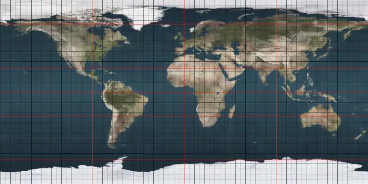
Circles of latitude between the 45th parallel north and the 50th parallel north
Following are circles of latitude between the 45th parallel north and the 50th parallel north:
46th parallel north
.svg.png)
The 46th parallel north is a circle of latitude that is 46 degrees north of the Earth's equatorial plane. It crosses Europe, Asia, the Pacific Ocean, North America, and the Atlantic Ocean.
At this latitude the sun is visible for 15 hours, 45 minutes during the summer solstice and 8 hours, 38 minutes during the winter solstice.[1]
Around the world
Starting at the Prime Meridian and heading eastwards, the parallel 46° north passes through:
47th parallel north
The 47th parallel north is a circle of latitude that is 47 degrees north of the Earth's equatorial plane. It crosses Europe, Asia, the Pacific Ocean, North America, and the Atlantic Ocean.
At this latitude the sun is visible for 15 hours, 54 minutes during the summer solstice and 8 hours, 31 minutes during the winter solstice.[2] This is the northern limit of the visibility of the star θ Scorpii and thus of the 'tail' of the constellation Scorpius.
Around the world
Starting at the Prime Meridian and heading eastwards, the parallel 47° north passes through:
48th parallel north
The 48th parallel north is a circle of latitude that is 48 degrees north of the Earth's equatorial plane. It crosses Europe, Asia, the Pacific Ocean, North America, and the Atlantic Ocean.
In Canada the parallel forms part of the border between Quebec and New Brunswick.
Ships heading north along the coast of Washington toward the Strait of Juan de Fuca must make radio contact with Canadian Coast Guard vessel traffic service upon crossing the 48th parallel.
At this latitude the sun is visible for 16 hours, 3 minutes during the summer solstice and 8 hours, 22 minutes during the winter solstice. If the latitude in the northern hemisphere is 48º50' or smaller, it is possible to view both astronomical dawn and dusk every day of the month of July. At the latitude of 48°33′38.58804” North, which is about 62.3 km (38.7 mi) north of this parallel, is the parallel where twilight/nighttime boundary on the June Solstice.[3]
Around the world
Starting at the Prime Meridian and heading eastwards, the parallel 48° north passes through:
Coordinates Country, territory or sea Notes 48°0′N 0°0′E / 48.000°N 0.000°E 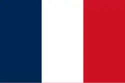 France
Brains-sur-Gée commune, Sarthe department 48°0′N 7°36′E / 48.000°N 7.600°E 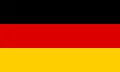 Germany
Baden-Württemberg - passing through Freiburg im Breisgau, less than 1 km north of the city centre
Bavaria - passing through Lake Ammer, and passing just south of Munich48°0′N 12°52′E / 48.000°N 12.867°E  Austria
48°0′N 17°9′E / 48.000°N 17.150°E  Hungary
For about 8 km 48°0′N 17°16′E / 48.000°N 17.267°E  Slovakia
48°0′N 18°49′E / 48.000°N 18.817°E Hungary48°0′N 22°51′E / 48.000°N 22.850°E  Ukraine
For about 6 km - Vynohradiv Raion 48°0′N 22°56′E / 48.000°N 22.933°E  Romania
For about 4 km 48°0′N 23°0′E / 48.000°N 23.000°E UkraineFor about 4 km - Vynohradiv Raion 48°0′N 23°3′E / 48.000°N 23.050°E Romania48°0′N 23°24′E / 48.000°N 23.400°E UkraineZakarpattia Oblast — passing just south of Rakhiv
Ivano-Frankivsk Oblast
Chernivtsi Oblast48°0′N 26°11′E / 48.000°N 26.183°E Romania48°0′N 27°8′E / 48.000°N 27.133°E  Moldova
Passing through Transnistria 48°0′N 28°54′E / 48.000°N 28.900°E UkraineOdesa Oblast — passing just north of Balta
Mykolaiv Oblast — passing just north of Yuzhnoukrainsk
Kirovohrad Oblast
Mykolaiv Oblast — for about 8 km
Kirovohrad Oblast — for about 2 km
Dnipropetrovsk Oblast — passing through Kryvyi Rih
Zaporizhzhia Oblast — passing just north of Zaporizhzhia
Donetsk Oblast — passing through Donetsk
Luhansk Oblast — passing just south of Dovzhansk48°0′N 39°48′E / 48.000°N 39.800°E  Russia
Rostov Oblast
Volgograd Oblast
Kalmykia
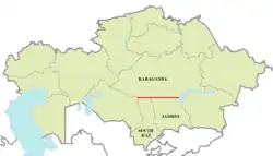
Astrakhan Oblast48°0′N 47°1′E / 48.000°N 47.017°E  Kazakhstan
48°0′N 85°34′E / 48.000°N 85.567°E  People's Republic of China
Xinjiang 48°0′N 89°2′E / 48.000°N 89.033°E  Mongolia
48°0′N 89°17′E / 48.000°N 89.283°E People's Republic of ChinaXinjiang 48°0′N 89°35′E / 48.000°N 89.583°E MongoliaPassing just north of Ulaanbaatar 48°0′N 115°30′E / 48.000°N 115.500°E People's Republic of ChinaInner Mongolia 48°0′N 117°47′E / 48.000°N 117.783°E Mongolia48°0′N 118°28′E / 48.000°N 118.467°E People's Republic of ChinaInner Mongolia
Heilongjiang48°0′N 130°44′E / 48.000°N 130.733°E RussiaJewish Autonomous Oblast 48°0′N 132°52′E / 48.000°N 132.867°E People's Republic of ChinaHeilongjiang 48°0′N 134°33′E / 48.000°N 134.550°E RussiaKhabarovsk Krai
Primorsky Krai
Khabarovsk Krai48°0′N 139°33′E / 48.000°N 139.550°E Strait of Tartary 48°0′N 142°12′E / 48.000°N 142.200°E RussiaIsland of Sakhalin 48°0′N 142°32′E / 48.000°N 142.533°E Sea of Okhotsk Passing between the islands of Rasshua and Ushishir in Russia's Kuril Island chain48°0′N 153°10′E / 48.000°N 153.167°E Pacific Ocean 48°0′N 124°41′W / 48.000°N 124.683°W .png) United States
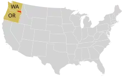
United StatesWashington - Olympic Peninsula (mainland), Whidbey Island, and the mainland at Everett
Idaho
Montana - passing through Fort Peck Dam
North Dakota - just south of Devils Lake; just north of Grand Forks
Minnesota - through Red Lake48°0′N 89°56′W / 48.000°N 89.933°W .svg.png) Canada
CanadaOntario - for about 7 km 48°0′N 89°50′W / 48.000°N 89.833°W United StatesMinnesota - passing through Grand Portage State Park 48°0′N 89°35′W / 48.000°N 89.583°W CanadaOntario - for about 2 km 48°0′N 89°34′W / 48.000°N 89.567°W Lake Superior 48°0′N 88°59′W / 48.000°N 88.983°W United StatesMichigan - Isle Royale 48°0′N 88°41′W / 48.000°N 88.683°W Lake Superior 48°0′N 85°54′W / 48.000°N 85.900°W CanadaOntario
Quebec48°0′N 69°47′W / 48.000°N 69.783°W Saint Lawrence River 48°0′N 69°30′W / 48.000°N 69.500°W CanadaQuebec - Île Verte and mainland
Quebec / New Brunswick border
Quebec
New Brunswick - passing through Campbellton48°0′N 66°19′W / 48.000°N 66.317°W Baie des Chaleurs Just passing south of the Gaspé Peninsula, Quebec, Canada48°0′N 64°33′W / 48.000°N 64.550°W CanadaNew Brunswick - Miscou Island - passing just south of the Miscou Island Lighthouse 48°0′N 64°29′W / 48.000°N 64.483°W Gulf of Saint Lawrence 48°0′N 59°17′W / 48.000°N 59.283°W CanadaNewfoundland and Labrador - island of Newfoundland.
From west to east, the parallel enters the island near the Anguille Mountains then passes near the community of North Branch. Further east it passes 1 km north of the Bay d'Espoir Generating Station, and through the community of Queen's Cove.48°0′N 53°39′W / 48.000°N 53.650°W Trinity Bay 48°0′N 53°19′W / 48.000°N 53.317°W CanadaNewfoundland and Labrador - Bay de Verde Peninsula, island of Newfoundland (from Hants Harbour to Lower Island Cove) 48°0′N 52°59′W / 48.000°N 52.983°W Atlantic Ocean 48°0′N 4°30′W / 48.000°N 4.500°W FranceQuimper, Brittany
49th parallel north
The 49th parallel north is a circle of latitude that is 49° north of Earth's equator. It crosses Europe, Asia, the Pacific Ocean, North America, and the Atlantic Ocean.
The city of Paris is about 15 km (9 mi) south of the 49th parallel and is the largest city between the 48th and 49th parallels. Its main airport, Charles de Gaulle Airport, lies on the parallel.
Roughly 2,030 kilometres (1,260 mi)[4] of the Canada–United States border was designated to follow the 49th parallel from British Columbia to Manitoba on the Canada side, and from Washington to Minnesota on the U.S. side, more specifically from the Strait of Georgia to the Lake of the Woods. This international border was specified in the Anglo-American Convention of 1818 and the Oregon Treaty of 1846, though survey markers placed in the 19th century cause the border to deviate from the 49th parallel by up to 810 metres (2,660 ft).
From a point on the ground at this latitude, the sun is above the horizon for 16 hours, 12 minutes during the summer solstice and 8 hours, 14 minutes during the winter solstice.[5]
This latitude also roughly corresponds to the minimum latitude in which astronomical twilight can last all night near the summer solstice. All-night astronomical twilight lasts from about June 9th to July 2nd."49°00'N, 45°00'E — Sunrise, Sunset, and Daylength, June 2024"."49°00'N, 45°00'E — Sunrise, Sunset, and Daylength, July 2024". At midnight on the summer solstice, the altitude of the sun is about −17.56°."Planets Visible in the Night Sky in 49°00'N, 45°00'E".
Slightly less than one-eighth of the Earth's surface is north of the 49th parallel.
Around the world
Starting at the Prime Meridian and heading eastwards, the parallel 49° north passes through:
Coordinates Country, territory or sea Notes 49°0′N 0°0′E / 49.000°N 0.000°E FranceNormandy
Île-de-France – crossing a runway of Charles de Gaulle Airport
Hauts-de-France
Grand Est49°0′N 8°4′E / 49.000°N 8.067°E GermanyRhineland-Palatinate
Baden-Württemberg – passing through Karlsruhe
Bavaria – passing through Regensburg49°0′N 13°24′E / 49.000°N 13.400°E  Czech Republic
Passing just north of České Budějovice 49°0′N 15°0′E / 49.000°N 15.000°E AustriaFor about 4.8 km (3 mi) 49°0′N 15°4′E / 49.000°N 15.067°E Czech RepublicFor about 5 km (3 mi) 49°0′N 15°8′E / 49.000°N 15.133°E AustriaFor about 120 m 49°0′N 15°8′E / 49.000°N 15.133°E Czech Republic49°0′N 17°57′E / 49.000°N 17.950°E SlovakiaTrenčín Region
Žilina Region
Prešov Region (passing through Prešov city centre)49°0′N 22°32′E / 49.000°N 22.533°E UkraineZakarpattia Oblast
Lviv Oblast
Ivano-Frankivsk Oblast – passing through Bolekhiv and Kolomyia
Ternopil Oblast – passing just south of Chortkiv
Khmelnytskyi Oblast
Vinnytsia Oblast – passing just south of Zhmerynka
Cherkassy Oblast – passing through Shpola
Kirovohrad Oblast
Poltava Oblast – passing just through Kremenchuk and Horishni Plavni
Dnipropetrovsk Oblast
Kharkiv Oblast
Donetsk Oblast – passing just through Lyman
Luhanska Oblast – passing through Rubizhne49°0′N 39°42′E / 49.000°N 39.700°E RussiaRostov Oblast
Volgograd Oblast49°0′N 46°55′E / 49.000°N 46.917°E Kazakhstan49°0′N 86°44′E / 49.000°N 86.733°E ChinaXinjiang 49°0′N 87°55′E / 49.000°N 87.917°E Mongolia49°0′N 116°8′E / 49.000°N 116.133°E ChinaInner Mongolia
Heilongjiang49°0′N 130°0′E / 49.000°N 130.000°E RussiaAmur Oblast
Jewish Autonomous Oblast
Khabarovsk Krai49°0′N 140°21′E / 49.000°N 140.350°E Strait of Tartary 49°0′N 142°1′E / 49.000°N 142.017°E RussiaIsland of Sakhalin 49°0′N 142°57′E / 49.000°N 142.950°E Sea of Okhotsk Gulf of Patience 49°0′N 144°26′E / 49.000°N 144.433°E RussiaIsland of Sakhalin 49°0′N 144°27′E / 49.000°N 144.450°E Sea of Okhotsk Passing between the islands of Kharimkotan and Ekarma in Russia's Kuril Island chain49°0′N 154°22′E / 49.000°N 154.367°E Pacific Ocean 49°0′N 125°41′W / 49.000°N 125.683°W CanadaBritish Columbia – Vancouver Island, Thetis Island and Galiano Island – passing through Ladysmith 49°0′N 123°34′W / 49.000°N 123.567°W Strait of Georgia 49°0′N 123°5′W / 49.000°N 123.083°W United StatesWashington (Point Roberts) 49°0′N 123°2′W / 49.000°N 123.033°W Boundary Bay Semiahmoo Bay 49°0′N 122°45′W / 49.000°N 122.750°W United StatesWashington 49°0′N 121°56′W / 49.000°N 121.933°W CanadaBritish Columbia 49°0′N 121°25′W / 49.000°N 121.417°W United StatesWashington 49°0′N 120°11′W / 49.000°N 120.183°W CanadaBritish Columbia 49°0′N 119°49′W / 49.000°N 119.817°W United StatesWashington 49°0′N 117°18′W / 49.000°N 117.300°W CanadaBritish Columbia 49°0′N 116°28′W / 49.000°N 116.467°W United StatesIdaho, Montana 49°0′N 115°21′W / 49.000°N 115.350°W CanadaBritish Columbia 49°0′N 114°57′W / 49.000°N 114.950°W United StatesMontana 49°0′N 114°12′W / 49.000°N 114.200°W CanadaBritish Columbia, Alberta, Saskatchewan 49°0′N 109°41′W / 49.000°N 109.683°W United StatesMontana 49°0′N 109°12′W / 49.000°N 109.200°W CanadaSaskatchewan 49°0′N 107°22′W / 49.000°N 107.367°W United StatesMontana 49°0′N 106°55′W / 49.000°N 106.917°W CanadaSaskatchewan, Manitoba 49°0′N 98°58′W / 49.000°N 98.967°W United StatesNorth Dakota, Minnesota 49°0′N 96°13′W / 49.000°N 96.217°W CanadaManitoba 49°0′N 95°17′W / 49.000°N 95.283°W Lake of the Woods Passing just south of Big Island and Bigsby Island, Ontario, Canada49°0′N 94°25′W / 49.000°N 94.417°W CanadaOntario – passing just south of Nipigon
Quebec – passing through Girardville49°0′N 68°38′W / 49.000°N 68.633°W St. Lawrence River 49°0′N 66°58′W / 49.000°N 66.967°W CanadaQuebec – Gaspé Peninsula – passing through Les Méchins and Gaspé 49°0′N 64°24′W / 49.000°N 64.400°W Gulf of St. Lawrence Passing just south of Anticosti Island, Quebec, Canada49°0′N 58°31′W / 49.000°N 58.517°W CanadaNewfoundland and Labrador – island of Newfoundland – passing through Pasadena and Bishop's Falls 49°0′N 53°44′W / 49.000°N 53.733°W Atlantic Ocean 49°0′N 5°38′W / 49.000°N 5.633°W English Channel Gulf of Saint-Malo – passing just south of the island of  Jersey
49°0′N 1°33′W / 49.000°N 1.550°W FranceNormandy
Ordnance Survey of Great Britain
The British national grid reference system uses the point 49° N, 2° W as its true origin. 49°00′00″N 2°00′00″W / 49.0000°N 2.0000°W[6]
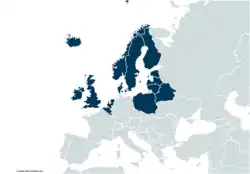
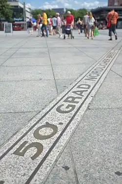
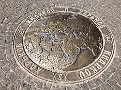
50th parallel north
The 50th parallel north is a circle of latitude that is 50 degrees north of the Earth's equatorial plane. It crosses Europe, Asia, the Pacific Ocean, North America, and the Atlantic Ocean.
At this latitude the sun is visible for 16 hours, 22 minutes during the summer solstice and 8 hours, 4 minutes during the winter solstice.[7] The maximum altitude of the sun during the summer solstice is 63.44 degrees and during the winter solstice it is 16.56 degrees. During the summer solstice, nighttime does not get beyond astronomical twilight, a condition which lasts throughout the month of June. It is possible to view both astronomical dawn and dusk every day of the month of May.[8]
At this latitude, the average sea surface temperature between 1982 and 2011 was about 8.5 °C (47.3 °F).[9]
Around the world
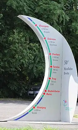
Starting at the Prime Meridian and heading eastwards, the parallel 50° north passes through:
Coordinates Country, territory or sea Notes 50°0′N 0°0′E / 50.000°N 0.000°E English Channel 50°0′N 1°15′E / 50.000°N 1.250°E FranceUpper Normandy — for about 20 km
Picardy — passing just north of Amiens
Nord-Pas-de-Calais — for about 13 km50°0′N 4°10′E / 50.000°N 4.167°E .svg.png) Belgium
BelgiumWallonia 50°0′N 4°40′E / 50.000°N 4.667°E FranceChampagne-Ardenne — for about 10 km 50°0′N 4°49′E / 50.000°N 4.817°E BelgiumWallonia 50°0′N 5°49′E / 50.000°N 5.817°E  Luxembourg
Diekirch District 50°0′N 6°9′E / 50.000°N 6.150°E GermanyRhineland-Palatinate
Hesse
Rhineland-Palatinate — passing through Mainz city centre
Hesse — passing just south of Frankfurt, crossing a runway of FRA international airport and passing just south of DCF77 time signal transmitter
Bavaria — passing just north of Bayreuth50°0′N 12°26′E / 50.000°N 12.433°E Czech RepublicPassing through southern parts of Prague 50°0′N 17°49′E / 50.000°N 17.817°E  Poland
For about 11 km 50°0′N 17°58′E / 50.000°N 17.967°E Czech RepublicFor about 10 km 50°0′N 18°7′E / 50.000°N 18.117°E PolandPassing through southern districts of Kraków (on the 20th meridian east)
Passing through southern districts of Tarnów (on the 21st meridian east)
Passing through southern districts of Rzeszów (on the 22nd meridian east)50°0′N 23°10′E / 50.000°N 23.167°E UkraineLviv Oblast — passing just north of Lviv
Ternopil Oblast — passing through Pochaiv
Khmelnytskyi Oblast
Zhytomyr Oblast — passing through Andrushivka
Kyiv Oblast
Cherkasy Oblast
Poltava Oblast — passing through Lubny
Kharkiv Oblast — passing through Kharkiv city centre50°0′N 37°57′E / 50.000°N 37.950°E RussiaBelgorod Oblast — for about 18 km 50°0′N 38°12′E / 50.000°N 38.200°E UkraineLuhansk Oblast — for about 12 km 50°0′N 38°22′E / 50.000°N 38.367°E RussiaBelgorod Oblast
Voronezh Oblast — passing just north of Boguchar
Rostov Oblast
Volgograd Oblast — passing just south of Kamyshin50°0′N 47°15′E / 50.000°N 47.250°E KazakhstanWest Kazakhstan Province — for about 63 km 50°0′N 48°8′E / 50.000°N 48.133°E RussiaSaratov Oblast — for about 55 km 50°0′N 48°51′E / 50.000°N 48.850°E KazakhstanWest Kazakhstan Province — passing just south of Chapaev and Zhympity and just north of Karatobe
Aktobe Province — passing just north of Alga and Karabutak
Kostanay Province — passing just south of Arkalyk
Karagandy Province — passing just south of Temirtau and just north of Karaganda
East Kazakhstan Province — passing through the northern outskirts of Oskemen50°0′N 85°2′E / 50.000°N 85.033°E RussiaAltai Republic
Tuva50°0′N 89°58′E / 50.000°N 89.967°E MongoliaPassing through the southern tip of Uvs Lake 50°0′N 95°1′E / 50.000°N 95.017°E RussiaTuva 50°0′N 95°45′E / 50.000°N 95.750°E MongoliaFor about 11 km 50°0′N 95°55′E / 50.000°N 95.917°E RussiaTuva — for about 7 km 50°0′N 96°2′E / 50.000°N 96.033°E MongoliaFor about 11 km 50°0′N 96°10′E / 50.000°N 96.167°E RussiaTuva 50°0′N 97°55′E / 50.000°N 97.917°E Mongolia50°0′N 107°13′E / 50.000°N 107.217°E RussiaBuryatia — for about 5 km 50°0′N 107°18′E / 50.000°N 107.300°E MongoliaFor about 3 km 50°0′N 107°20′E / 50.000°N 107.333°E RussiaBuryatia
Zabaykalsky Krai50°0′N 113°34′E / 50.000°N 113.567°E Mongolia50°0′N 115°12′E / 50.000°N 115.200°E RussiaZabaykalsky Krai 50°0′N 116°1′E / 50.000°N 116.017°E Mongolia50°0′N 116°20′E / 50.000°N 116.333°E RussiaZabaykalsky Krai 50°0′N 119°6′E / 50.000°N 119.100°E People's Republic of ChinaInner Mongolia
Heilongjiang50°0′N 127°29′E / 50.000°N 127.483°E RussiaAmur Oblast
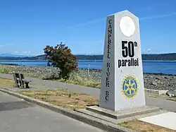
Khabarovsk Krai50°0′N 140°30′E / 50.000°N 140.500°E Strait of Tartary 50°0′N 142°9′E / 50.000°N 142.150°E RussiaSakhalin Oblast — island of Sakhalin 50°0′N 143°59′E / 50.000°N 143.983°E Sea of Okhotsk 50°0′N 155°23′E / 50.000°N 155.383°E RussiaSakhalin Oblast — island of Paramushir 50°0′N 155°24′E / 50.000°N 155.400°E Pacific Ocean 50°0′N 127°19′W / 50.000°N 127.317°W CanadaBritish Columbia — Vancouver Island (passing through the town of Campbell River) and mainland, also through the Okanagan Valley immediately north of Kelowna.
Alberta — passing through the city of Medicine Hat
Saskatchewan it passes a few km south of the cities of Swift Current, Moose Jaw and the capital, Regina
Manitoba — passing just north of Winnipeg
Ontario — passing through Lake Nipigon
Quebec - passing through the town of Port-Cartier50°0′N 66°54′W / 50.000°N 66.900°W Gulf of Saint Lawrence Passing just north of Anticosti Island, Quebec, Canada50°0′N 57°45′W / 50.000°N 57.750°W CanadaNewfoundland and Labrador — island of Newfoundland 50°0′N 56°46′W / 50.000°N 56.767°W White Bay 50°0′N 56°21′W / 50.000°N 56.350°W CanadaNewfoundland and Labrador — island of Newfoundland 50°0′N 55°52′W / 50.000°N 55.867°W Atlantic Ocean Confusion Bay 50°0′N 55°33′W / 50.000°N 55.550°W CanadaNewfoundland and Labrador — island of Newfoundland 50°0′N 55°31′W / 50.000°N 55.517°W Atlantic Ocean Passing just north of the Isles of Scilly, England,  United Kingdom
50°0′N 5°16′W / 50.000°N 5.267°W United KingdomEngland — Lizard Peninsula, Cornwall, for about 7 km 50°0′N 5°10′W / 50.000°N 5.167°W English Channel
Sakhalin island
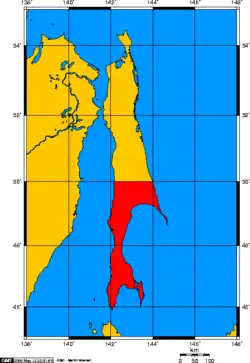
From the signing of the 1875 Treaty of Saint Petersburg until the Russo-Japanese War which broke in 1904, the Russian Empire had full control of Sakhalin island. As a result of the 1905 Treaty of Portsmouth that brought an end to the Russo-Japanese War, the portion of the island south of the 50th parallel line became Japanese territory, part of Karafuto Prefecture. However, following the month long Soviet–Japanese War during the summer of 1945, the entire island was reunified under Soviet control.[10]
See also
- Circles of latitude between the 40th parallel north and the 45th parallel north
- Circles of latitude between the 50th parallel north and the 55th parallel north
- 49th Parallel, 1941 Canadian and British film
- Hymns of the 49th Parallel, 2004 album by k.d. lang
- Boundary Lake (Manitoba/North Dakota)
- Northwest Angle (northern Lake of the Woods County)
- Oregon boundary dispute
- Pig War, 1859
- War of 1812
- Weißwurstäquator
References
- ↑ "Duration of Daylight/Darkness Table for One Year". U.S. Naval Observatory. 24 September 2019. Archived from the original on 12 October 2019. Retrieved 10 March 2021.
- ↑ "Duration of Daylight/Darkness Table for One Year". U.S. Naval Observatory. 24 September 2019. Archived from the original on 12 October 2019. Retrieved 10 March 2021.
- ↑ "Duration of Daylight/Darkness Table for One Year". U.S. Naval Observatory. 24 September 2019. Archived from the original on 12 October 2019. Retrieved 10 March 2021.
- ↑ Jacobs, Frank (28 November 2011), "The Not-So-Straight Story of the U.S.-Canadian Border", New York Times, retrieved 13 May 2020
- ↑ "Duration of Daylight/Darkness Table for One Year". U.S. Naval Observatory. 24 September 2019. Archived from the original on 12 October 2019. Retrieved 10 March 2021.
- ↑ "The true origin". Welcome to OS Net. Southampton: Ordnance Survey. 4 September 2007. Archived from the original on 29 April 2007. Retrieved 13 August 2009.
- ↑ "Duration of Daylight/Darkness Table for One Year". U.S. Naval Observatory. 24 September 2019. Archived from the original on 12 October 2019. Retrieved 10 March 2021.
- ↑ "Earth-Sun geometry - The Encyclopedia of Earth". www.eoearth.org.
- ↑ "Zonal Mean Sea Surface Temperatures (5 deg Latitude Bands) Average of Jan 1982 to Dec 2011". Retrieved 7 July 2022.
- ↑ Sevela, Mariya. "Sakhalin: the Japanese Under Soviet Rule". History Today. Retrieved 10 May 2014.
Circles of latitude / meridians | |
|---|---|
45x90
45x90
45x90
45x90
|