Circles of latitude between the 35th parallel north and the 40th parallel north
Following are circles of latitude between the 35th parallel north and the 40th parallel north:
36th parallel north
.svg.png)
The 36th parallel north is a circle of latitude that is 36 degrees north of the Earth's equatorial plane. It crosses Africa, the Mediterranean Sea, Asia, the Pacific Ocean, North America and the Atlantic Ocean. In the ancient Mediterranean world, its role for navigation and geography was similar to that played by the Equator today.[1]
From 7 April 1991 to 31 December 1996, the parallel defined the limit of the northern no-fly zone in Iraq.[2]
At this latitude the sun is visible for 14 hours, 36 minutes during the summer solstice and 9 hours, 43 minutes during the winter solstice.[3]
United States
In the United States, the 36th parallel north is occasionally used as a rough northern boundary for the Sun Belt, a region spanning most Southern and Southwestern states and comprising most of the nation's warmest climates.
Cities and landmarks close to the parallel include the following: Kettleman City, California; Henderson, Nevada; Hoover Dam; South Rim of the Grand Canyon; Los Alamos National Laboratory; Tulsa, Oklahoma (passing through the southern portion of the city); Nashville, Tennessee (passing through the southern portion of the city); Knoxville, Tennessee; Winston-Salem, North Carolina; High Point, North Carolina; Greensboro, North Carolina; Durham, North Carolina; Chapel Hill, North Carolina; and others. The parallel helped define the North Carolina–Tennessee–Virginia Corners.
The sixth standard parallel south of Mount Diablo Range at 35°48′ north, 13.8344 miles south of the 36th parallel, forms a continuous boundary between the California counties of Monterey, Kings, Tulare, and Inyo on the north and the counties of San Luis Obispo, Kern, and San Bernardino on the south.[4] It is sometimes taken as the boundary between Central California and Southern California.[5]
The parallel 36° north approximately forms the southernmost boundary of the Missouri Bootheel with the State of Arkansas.
The 36th parallel passes through Duke University in several places. Its Campus Drive that connects the campuses crosses the parallel several times. The Duke Gardens has a "36th Parallel Club" although the garden itself is just north of the parallel.
Around the world
Starting at the Prime Meridian and heading eastwards, the parallel 36° north passes through:
Coordinates Country, territory or sea Notes 36°0′N 0°0′E / 36.000°N 0.000°E Mediterranean Sea 36°0′N 0°7′E / 36.000°N 0.117°E  Algeria
Passing through Mostaganem 36°0′N 8°18′E / 36.000°N 8.300°E  Tunisia
36°0′N 10°31′E / 36.000°N 10.517°E Mediterranean Sea Passing just north of the island of Linosa,  Italy
Italy
Passing between the islands of Comino and Malta, Malta
Malta36°0′N 23°10′E / 36.000°N 23.167°E Aegean Sea Passing between the islands of Kythira and Antikythera,  Greece
Passing just north of Saria Island, Greece36°0′N 27°45′E / 36.000°N 27.750°E GreeceIsland of Rhodes 36°0′N 27°55′E / 36.000°N 27.917°E Mediterranean Sea 36°0′N 35°59′E / 36.000°N 35.983°E  Turkey
Hatay Province 36°0′N 36°22′E / 36.000°N 36.367°E .svg.png) Syria
SyriaPassing just north of Raqqa 36°0′N 41°17′E / 36.000°N 41.283°E  Iraq
Iraq36°0′N 45°21′E / 36.000°N 45.350°E  Iran
Iran36°0′N 61°10′E / 36.000°N 61.167°E  Turkmenistan
36°0′N 63°49′E / 36.000°N 63.817°E  Afghanistan
36°0′N 71°15′E / 36.000°N 71.250°E  Pakistan
Khyber Pakhtunkhwa
Gilgit-Baltistan - claimed by India
India36°0′N 76°6′E / 36.000°N 76.100°E Shaksgam Valley Area administered by  People's Republic of China, claimed by India
36°0′N 76°48′E / 36.000°N 76.800°E People's Republic of ChinaXinjiang
Tibet
Qinghai
Gansu — passing just south of Lanzhou
Ningxia
Gansu
Shaanxi
Shanxi
Henan
Shandong
Henan (for about 15 km (9.3 mi))
Shandong — passing just south of Qingdao36°0′N 120°18′E / 36.000°N 120.300°E Yellow Sea 36°0′N 126°42′E / 36.000°N 126.700°E  South Korea
South Chungcheong Province - North Jeolla Province Border, Passing just north of Gunsan, Iksan
North Jeolla Province-North Chungcheong Province-North Gyeongsang Province Border
North Gyeongsang Province - Passing just south of Gumi
passing just north of Daegu-Palgong Mountain
North Gyeongsang Province- Passing through Pohang36°0′N 129°35′E / 36.000°N 129.583°E Sea of Japan 36°0′N 133°1′E / 36.000°N 133.017°E  Japan
JapanIsland of Chiburi-shima:
— Shimane Prefecture36°0′N 133°4′E / 36.000°N 133.067°E Sea of Japan 36°0′N 135°58′E / 36.000°N 135.967°E JapanIsland of Honshū:
— Fukui Prefecture
— Gifu Prefecture
— Nagano Prefecture
— Gunma Prefecture − for about 4 km (2.5 mi)
— Saitama Prefecture
— Chiba Prefecture − for about 6 km (3.7 mi)
— Ibaraki Prefecture36°0′N 140°40′E / 36.000°N 140.667°E Pacific Ocean 36°0′N 121°30′W / 36.000°N 121.500°W .png) United States
United StatesCalifornia
Nevada - Just South Of Las Vegas
Arizona
New Mexico
Texas
Oklahoma
Arkansas
Missouri / Arkansas border (approximate)
Tennessee
North Carolina (Madison County, for about 14 km (8.7 mi))
Tennessee (Unicoi County, for about 12 km (7.5 mi))
North Carolina36°0′N 75°39′W / 36.000°N 75.650°W Atlantic Ocean 36°0′N 5°36′W / 36.000°N 5.600°W Strait of Gibraltar Passing 2 m (6.6 ft) south of Punta de Tarifa,  Spain - the most southerly point of the European mainland
36°0′N 5°25′W / 36.000°N 5.417°W Mediterranean Sea
37th parallel north
The 37th parallel north is a circle of latitude that is 37 degrees north of the Earth's equatorial plane. It crosses Europe, the Mediterranean Sea, Africa, Asia, the Pacific Ocean, North America, and the Atlantic Ocean.
At this latitude, the Sun is visible for 14 hours, 42 minutes during the summer solstice and 9 hours, 37 minutes during the winter solstice.[6]
The 37th parallel north is roughly the northern limit of the visibility of Canopus, the second-brightest star of the night sky. Along with the 37th parallel south, it is the latitude at which solar irradiance is closest to the planetary average,[7] with higher solar irradiance equatorward and lower poleward.
United States
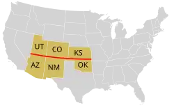
In the United States, the parallel defines the southern borders of Utah, Colorado, and Kansas, and the northern borders of Arizona, New Mexico, and Oklahoma. It dates to the Kansas–Nebraska Act of 1854 when Congress divided Unorganized Territory into Kansas and Nebraska north of the 37th parallel and a remainder Indian Territory to the south. Before that, the line had been thought to be the boundary between the Cherokee and Osage reservations – the 2.46 miles (3.96 km) discrepancy resulting in the creation of the Cherokee Strip. Congress extended the line west to New Mexico Territory, thus defining which states and territories would constitute The South between the Colorado and Mississippi Rivers, and creating what later became the Oklahoma Panhandle.[8]
The parallel 37° north formed the southern boundary of the historic and extralegal Territory of Jefferson.
U.S. Landmarks located on or in close proximity of the 37th parallel
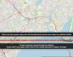
- Santa Cruz, California – Located on the exact entry point into the U.S. at Bonny Doon Beach.
- Yosemite National Park — Situated in close proximity, just north of the 37th parallel.
- Death Valley – The 37th parallel runs approximately 1,300 ft south of the Little Hebe Crater rim and approximately 1,900 ft south of the larger Ubehebe Crater rim, a crater that's 800 meters (2,600 ft) wide and 235 meters (771 ft) deep.
- Area 51, Nevada — Also known as "Groom Lake".
- Four Corners, the only point where four U.S. states meet.
- Cairo, Illinois – The southernmost city in Illinois.
- Bowling Green, Kentucky
- Chesapeake Bay Bridge–Tunnel – A critical maritime and transportation structure.
Around the world
Starting at the Prime Meridian and heading eastward, the parallel 37° north passes through:
38th parallel north
The 38th parallel north is a circle of latitude that is 38 degrees north of the Earth's equatorial plane. It crosses Europe, the Mediterranean Sea, Asia, the Pacific Ocean, North America, and the Atlantic Ocean. The 38th parallel north formed the border between North and South Korea prior to the Korean War.
At this latitude, the Sun is visible for 14 hours, 48 minutes during the summer solstice and 9 hours, 32 minutes during the winter solstice.[9]
Korea
| 38th parallel north | |
| Hangul | 삼팔선 |
|---|---|
| Hanja | 三八線 |
| Revised Romanization | Sampalseon |
| McCune–Reischauer | Samp'alsŏn |
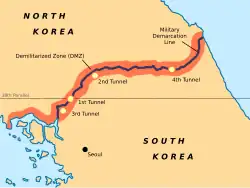
Japan had ruled the Korean Peninsula between 1910 and 1945. When Japan surrendered in August 1945, the 38th parallel was established as the boundary between Soviet and American occupation zones. This parallel divided the Korean peninsula roughly in the middle. In 1948, this parallel became the boundary between the Democratic People's Republic of Korea (North Korea) and the Republic of Korea (South Korea), both of which claim to be the government of the whole of Korea. On 25 June 1950, after a series of cross-border raids and gunfire from both the Northern and the Southern sides, the North Korean Army crossed the 38th parallel and invaded South Korea. This sparked United Nations Security Council Resolution 82 which called for the North to return its troops to behind the 38th parallel, commencing the Korean War with United Nations troops (mostly American) helping South Korean troops to defend South Korea.[10]
After the Armistice agreement was signed on July 27, 1953, a new line was established to separate North Korea and South Korea. This Military Demarcation Line is surrounded by a Demilitarized Zone. The demarcation line crosses the 38th parallel, from the southwest to the northeast.
Around the world
Starting at the Prime Meridian heading eastward, the 38th parallel north passes through:
Coordinates Country, territory or sea Notes 38°0′N 0°0′E / 38.000°N 0.000°E Mediterranean Sea Passing just north of the island of Marettimo, Italy (at 37°59′43″N 12°1′47″E / 37.99528°N 12.02972°E)38°0′N 12°19′E / 38.000°N 12.317°E ItalyIslands of Levanzo and Sicily 38°0′N 15°25′E / 38.000°N 15.417°E Mediterranean Sea Strait of Messina 38°0′N 15°38′E / 38.000°N 15.633°E ItalyPassing through Reggio di Calabria (southern suburbs) 38°0′N 16°8′E / 38.000°N 16.133°E Mediterranean Sea Ionian Sea - passing between the islands of Kefalonia (at 38°4′N 20°43′E / 38.067°N 20.717°E) and Zakynthos (at 37°56′N 20°42′E / 37.933°N 20.700°E), Greece38°0′N 21°16′E / 38.000°N 21.267°E GreecePassing through Athens 38°0′N 24°2′E / 38.000°N 24.033°E Aegean Sea 38°0′N 24°14′E / 38.000°N 24.233°E GreeceIslands of Petalioi and Euboea 38°0′N 24°34′E / 38.000°N 24.567°E Aegean Sea Passing just north of the island of Andros (at 37°59′57″N 24°47′23″E / 37.99917°N 24.78972°E), Greece38°0′N 27°7′E / 38.000°N 27.117°E TurkeyPassing through Konya, Niğde and İzmir (southern suburbs) 38°0′N 44°17′E / 38.000°N 44.283°E IranPassing just south of Tabriz 38°0′N 48°55′E / 38.000°N 48.917°E Caspian Sea 38°0′N 53°49′E / 38.000°N 53.817°E Turkmenistan38°0′N 55°17′E / 38.000°N 55.283°E Iran38°0′N 57°22′E / 38.000°N 57.367°E TurkmenistanPassing just north of Ashgabat 38°0′N 66°38′E / 38.000°N 66.633°E  Uzbekistan
38°0′N 68°17′E / 38.000°N 68.283°E  Tajikistan
38°0′N 70°19′E / 38.000°N 70.317°E Afghanistan38°0′N 71°16′E / 38.000°N 71.267°E Tajikistan38°0′N 74°54′E / 38.000°N 74.900°E People's Republic of ChinaXinjiang
Qinghai
Gansu
Inner Mongolia
Ningxia
Inner Mongolia
Shaanxi − for around 5 km (3.1 mi)
Inner Mongolia − for around 14 km (8.7 mi)
Shaanxi
Shanxi — passing just north of Taiyuan
Hebei — passing just south of Shijiazhuang
Shandong38°0′N 118°58′E / 38.000°N 118.967°E Yellow Sea Passing just north of Baengnyeongdo (at 37°59′N 124°41′E / 37.983°N 124.683°E), South Korea38°0′N 125°7′E / 38.000°N 125.117°E  North Korea
Ongjin Peninsula — South Hwanghae Province 38°0′N 125°35′E / 38.000°N 125.583°E Yellow Sea Ongjin Bay 38°0′N 125°46′E / 38.000°N 125.767°E North KoreaSouth Hwanghae Province
passing just south of Haeju
North Hwanghae Province
passing just north of Kaesong38°0′N 126°49′E / 38.000°N 126.817°E South KoreaGyeonggi Province- Passing through Paju, Yeoncheon County, Pocheon, Gapyeong County
Gangwon Province - Passing through Hwacheon County, Chuncheon, (passing just north of Soyang Reservoir), Inje County, Yangyang County38°0′N 128°44′E / 38.000°N 128.733°E Sea of Japan 38°0′N 138°14′E / 38.000°N 138.233°E JapanIsland of Sado:
— Niigata Prefecture38°0′N 138°33′E / 38.000°N 138.550°E Sea of Japan 38°0′N 139°14′E / 38.000°N 139.233°E JapanIsland of Honshū:
— Niigata Prefecture
Passing just north of Niigata City
— Yamagata Prefecture
— Miyagi Prefecture38°0′N 140°55′E / 38.000°N 140.917°E Pacific Ocean 38°0′N 123°1′W / 38.000°N 123.017°W United StatesCalifornia - passing through Pinole and Stockton With Sacramento a little to the north
Nevada - passing just south of Tonopah
Utah - passing through Capitol Reef and Canyonlands National Parks
Colorado - passing through Ouray, and then just south of Pueblo
Kansas - passing just south of Newton
Missouri - passing through Camdenton and just north of Rolla
Illinois - passing just south of Mount Vernon
Indiana - passing through Evansville
Kentucky - passing through Lexington
West Virginia - passing just north of Beckley
Virginia - passing just south of Charlottesville38°0′N 76°28′W / 38.000°N 76.467°W Chesapeake Bay 38°0′N 75°53′W / 38.000°N 75.883°W United StatesMaryland - passing just north of Smith Island and Crisfield
Virginia - passing just north of Chincoteague38°0′N 75°16′W / 38.000°N 75.267°W Atlantic Ocean Passing between Pico (at 38°23′N 28°14′W / 38.383°N 28.233°W) and São Miguel (at 37°55′N 25°47′W / 37.917°N 25.783°W) islands, Azores,  Portugal
38°0′N 8°51′W / 38.000°N 8.850°W PortugalSetúbal District
Beja District - passing just south of Beja38°0′N 7°12′W / 38.000°N 7.200°W SpainAndalusia
Extremadura
Region of Murcia - passing just north of Murcia
Valencian Community38°0′N 0°39′W / 38.000°N 0.650°W Mediterranean Sea
39th parallel north
The 39th parallel north is a circle of latitude that is 39 degrees north of the Earth's equatorial plane. It crosses Europe, the Mediterranean Sea, Asia, the Pacific Ocean, North America, and the Atlantic Ocean.
At this latitude the sun is visible for 14 hours, 54 minutes during the summer solstice and 9 hours, 26 minutes during the winter solstice.[11]
Daylight along the 39th parallel north falls under 10 hours a day starting on 18 November and returns to over ten hours a day beginning 24 January. The growth of crops and other plants is considerably slowed during this period of reduced sunlight.
In the United States, the eastern boundary of the state of California was defined as following the 120th meridian west south from the 42nd parallel north to its intersection with the 39th parallel north, beyond which it follows a diagonal line to where the Colorado River crosses the 35th parallel north.[12] The intersection of the 120th meridian and 39th parallel is in Lake Tahoe.
Around the world
Starting at the Prime Meridian and heading eastwards, the parallel 39° north passes through:
40th parallel north
The 40th parallel north is a circle of latitude that is 40 degrees north of the Earth's equatorial plane. It crosses Europe, the Mediterranean Sea, Asia, the Pacific Ocean, North America, and the Atlantic Ocean.
At this latitude the sun is visible for 15 hours, 1 minute and 28 seconds during the summer solstice and 9 hours, 20 minutes during the winter solstice.[13] On 21 June, the maximum altitude of the sun is 73.44 degrees, while it is 26.56 degrees on 21 December.
The maximum altitude of the Sun is > 35.00º in October and > 28.00º in November.
The 40th parallel north is the southern baseline for Canada's National Topographic System.
United States
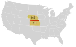
The parallel 40° north formed the boundary between the Kansas and Nebraska territories, as per the Kansas–Nebraska Act of 1854. It remains the boundary between the modern states of Kansas and Nebraska.
The parallel 40° north formed the original northern boundary of the British Colony of Maryland. A subsequent royal grant gave the Colony of Pennsylvania land north of the 40th parallel but mistakenly assumed it would intersect the Twelve Mile Circle, which it does not. Pennsylvania's border was thus unclear and the colony pushed for a border far south of the 40th parallel. The Mason–Dixon Line was drawn between 1763 and 1767 as the compromise boundary between the overlapping claims of these two colonies.
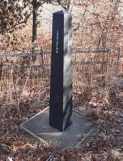
.jpg)
The parallel 40° north passes through the cities of Philadelphia, Pennsylvania, Boulder, Colorado, and Columbus, Ohio; as well as northern suburbs of Indianapolis, Indiana and the southern suburbs of Pittsburgh, Pennsylvania. The parallel goes directly through the John Glenn Columbus International Airport, with runway 10L-28R lying immediately north of the line, runway 10R-28L lying slightly south of it, and the line going through the northernmost edges of the terminal. It also passes through the main campus of The Ohio State University; specifically, it cuts directly across the Oval greenspace, between University Hall and the William Oxley Thompson Memorial Library. Ohio Stadium, one of the largest stadiums in the world, barely misses the parallel 40° north (6 seconds or 185 metres (607 ft) above 40° north).
Baseline Road in Boulder, Colorado, traces the parallel 40° north.
Thistle, Utah, a ghost town since 1983, is slightly (30 seconds or 956 metres (0.594 mi)) below 40° north.
Japan
Gallery
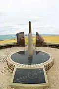 Monument of North latitude 40 degrees at Nyudouzaki in Oga, Akita
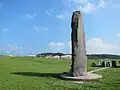 Nyudozaki Monument
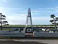 40°N and 140°E Crossing Point in Ogata, Akita
 Globe Monument in Fudai, Iwate
Around the world
Starting in Spain at the Prime Meridian and heading eastwards, the parallel 40° north passes through:
Coordinates Country, territory or sea Notes 40°0′N 0°0′E / 40.000°N 0.000°E SpainValencian Community 40°0′N 0°2′E / 40.000°N 0.033°E Mediterranean Sea Passing just north of the island of Majorca, Spain40°0′N 3°48′E / 40.000°N 3.800°E SpainIsland of Menorca 40°0′N 4°13′E / 40.000°N 4.217°E Mediterranean Sea 40°0′N 8°24′E / 40.000°N 8.400°E ItalyIsland of Sardinia 40°0′N 9°42′E / 40.000°N 9.700°E Mediterranean Sea Tyrrhenian Sea 40°0′N 15°20′E / 40.000°N 15.333°E ItalyCampania 40°0′N 15°26′E / 40.000°N 15.433°E Mediterranean Sea Gulf of Policastro 40°0′N 15°41′E / 40.000°N 15.683°E ItalyBasilicata, Calabria 40°0′N 16°37′E / 40.000°N 16.617°E Mediterranean Sea Gulf of Taranto 40°0′N 18°0′E / 40.000°N 18.000°E ItalyApulia 40°0′N 18°25′E / 40.000°N 18.417°E Mediterranean Sea Strait of Otranto 40°0′N 19°53′E / 40.000°N 19.883°E  Albania
Passing just north of Sarandë and just south of Gjirokastër 40°0′N 20°23′E / 40.000°N 20.383°E Greece40°0′N 22°37′E / 40.000°N 22.617°E Mediterranean Sea Aegean Sea 40°0′N 23°23′E / 40.000°N 23.383°E GreeceKassandra and Sithonia 40°0′N 24°0′E / 40.000°N 24.000°E Mediterranean Sea Aegean Sea 40°0′N 25°6′E / 40.000°N 25.100°E GreeceIsland of Lemnos 40°0′N 25°26′E / 40.000°N 25.433°E Mediterranean Sea Aegean Sea 40°0′N 26°11′E / 40.000°N 26.183°E TurkeyPassing just north of Ankara 40°0′N 44°24′E / 40.000°N 44.400°E 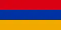 Armenia
Passing through Verin Artashat and Norashen, Ararat 40°0′N 45°36′E / 40.000°N 45.600°E  Azerbaijan
Passing through Karabakh and Kur-Araz Lowland 40°0′N 49°27′E / 40.000°N 49.450°E Caspian Sea 40°0′N 52°46′E / 40.000°N 52.767°E Turkmenistan40°0′N 62°26′E / 40.000°N 62.433°E Uzbekistan40°0′N 68°48′E / 40.000°N 68.800°E Tajikistan40°0′N 69°31′E / 40.000°N 69.517°E  Kyrgyzstan
40°0′N 70°32′E / 40.000°N 70.533°E TajikistanFor about 9 km (5.6 mi) 40°0′N 70°39′E / 40.000°N 70.650°E Kyrgyzstan40°0′N 71°5′E / 40.000°N 71.083°E UzbekistanSokh exclave - for about 7 km (4.3 mi) 40°0′N 71°10′E / 40.000°N 71.167°E Kyrgyzstan40°0′N 71°48′E / 40.000°N 71.800°E UzbekistanShohimardon exclave - for about 4 km (2.5 mi) 40°0′N 71°50′E / 40.000°N 71.833°E Kyrgyzstan40°0′N 73°58′E / 40.000°N 73.967°E ChinaXinjiang
Gansu
Inner Mongolia
Shanxi
Hebei
Beijing (passing just north of the city centre)
Hebei
Tianjin
Hebei
Liaoning (for about 8 km (5.0 mi))40°0′N 119°54′E / 40.000°N 119.900°E Pacific Ocean Liaodong Bay, Yellow Sea 40°0′N 121°53′E / 40.000°N 121.883°E ChinaLiaoning (Liaodong Peninsula) 40°0′N 124°21′E / 40.000°N 124.350°E North KoreaNorth Pyeongan Province - Passing through Sinuiju
Jagang Province
South Hamgyeong Province - Passing just north of Hamheung40°0′N 127°57′E / 40.000°N 127.950°E Pacific Ocean Sea of Japan 40°0′N 128°10′E / 40.000°N 128.167°E North KoreaMayang Island 40°0′N 128°13′E / 40.000°N 128.217°E Pacific Ocean Sea of Japan 40°0′N 139°54′E / 40.000°N 139.900°E JapanIsland of Honshū
— Akita Prefecture
— Iwate Prefecture40°0′N 141°57′E / 40.000°N 141.950°E Pacific Ocean 40°0′N 124°1′W / 40.000°N 124.017°W United StatesCalifornia - passing 2.35 km (1.46 mi) south of Shelter Cove
Nevada
Utah
Colorado - passing through Boulder
Nebraska / Kansas border
Missouri
Illinois
Indiana - passing through Hoosier Hill, the state high point
Ohio - passing through Columbus
West Virginia
Pennsylvania - passing through Philadelphia
New Jersey - passing through Toms River40°0′N 31°7′W / 40.000°N 31.117°W Atlantic Ocean Passing just north of Corvo Island, Azores, Portugal40°0′N 8°55′W / 40.000°N 8.917°W PortugalPassing near Figueira da Foz and Coimbra 40°0′N 6°51′W / 40.000°N 6.850°W SpainExtremadura
Castile-La Mancha
Community of Madrid - for about 10 km (6.2 mi)
Castile-La Mancha
Valencian Community - Rincón de Ademuz exclave, for about 4 km (2.5 mi)
Castile-La Mancha - for about 5 km (3.1 mi)
Aragon
Valencian Community
Notable cities and towns on 40°N
- Ankara, Turkey
- Beijing, China
- Columbus, Ohio, United States
- Denver, Colorado, United States
- Madrid, Spain
- Naples, Italy
- Philadelphia, Pennsylvania, United States
- Yerevan, Armenia
See also
- Circles of latitude between the 30th parallel north and the 35th parallel north
- Circles of latitude between the 40th parallel north and the 45th parallel north
- Baseline (surveying)
- Geological Exploration of the Fortieth Parallel
- Parallel 36°30′ north
- 38th parallel structures, series of circular depressions roughly on the 38th parallel north
- 17th parallel north, similar line dividing North and South Vietnam
References
- ↑ FEDERACION DE TROPAS Y LEGIONES (5 September 2012). "Revista Oficial Carthagineses y Romanos 2012".
- ↑ "Containment: The Iraqi no-fly zones". BBC News. 29 December 1998. Retrieved 4 February 2012.
- ↑ "Duration of Daylight/Darkness Table for One Year". U.S. Naval Observatory. 24 September 2019. Archived from the original on 2019-10-12. Retrieved 2021-03-10.
- ↑ California (1 January 1886). The Codes and Statutes of California, as Amended and in Force at the Close of the Twenty-sixth Session of the Legislature, 1885: With Notes Containing References to All the Decisions of the Supreme Court Construing Or Illustrating the Sections of the Codes, and to Adjudications of the Courts of Other States Having Like Code Provisions. A. L. Bancroft.
- ↑ California, Historical Society of Southern; California, Los Angeles County Pioneers of Southern (1 January 1901). The Quarterly.
- ↑ "Duration of Daylight/Darkness Table for One Year". U.S. Naval Observatory. 2019-09-24.
- ↑ See Nadeau, Alice and McGhee, Richard; ‘A simple formula for a planet's mean annual insolation by latitude’; Icarus, volume 291, 15 July 2017, pp. 46-50
- ↑ Hubbard, Bill (2009). American Boundaries: The Nation, the States, the Rectangular Survey. University of Chicago Press. p. 158. ISBN 978-0-226-35591-7. Retrieved 27 September 2012.
- ↑ "Duration of Daylight/Darkness Table for One Year". aa.usno.navy.mil. Archived from the original on 2019-10-12. Retrieved 2011-06-12.
- ↑ Nash, Gary B. (2008). The American People: Creating a Nation and a Society (Concise 6th ed.). New York: Pearson Longman.
- ↑ "Duration of Daylight/Darkness Table for One Year". U.S. Naval Observatory. 2019-09-24. Archived from the original on 2019-10-12. Retrieved 2021-03-10.
- ↑ Hubbard, Bill (2009). American Boundaries: The Nation, the States, the Rectangular Survey. University of Chicago Press. pp. 156–157. ISBN 978-0-226-35591-7. Retrieved 27 September 2012.
- ↑ "Duration of Daylight/Darkness Table for One Year". U.S. Naval Observatory. 2019-09-24. Archived from the original on 2019-10-12. Retrieved 2021-03-10.
Further reading
- Oberdorfer, Don. The Two Koreas: A Contemporary History. (1997)
- 38th parallel (geopolitics) at the Encyclopædia Britannica
Circles of latitude / meridians | |
|---|---|
45x90
45x90
45x90
45x90
|