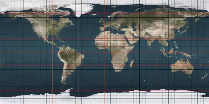
Circles of latitude between the 10th parallel north and the 15th parallel north
Following are circles of latitude between the 10th parallel north and the 15th parallel north:
11th parallel north
.svg.png)
The 11th parallel north is a circle of latitude that is 11 degrees north of the Earth's equatorial plane. It crosses Africa, the Indian Ocean, South Asia, Southeast Asia, the Pacific Ocean, Central America, South America, and the Atlantic Ocean.
At this latitude the sun is visible for 12 hours, 46 minutes during the summer solstice and 11 hours, 29 minutes during the winter solstice.[1]
In Thailand, a 1966 cabinet resolution restricts the rights of non-Thai companies to conduct mineral exploration or mining operations north of this parallel.[2]
As a border
The border between Ghana and what was then French Upper Volta (now Burkina Faso) was fixed by treaty between the French and British at the Conference of Paris in 1898, to be the 11th parallel.[3] The border does not follow the boundary exactly, but follows it approximately, crossing over it several times.
Around the world
Starting at the Prime Meridian and heading eastwards, the parallel 11° north passes through:
12th parallel north
The 12th parallel north is a circle of latitude that is 12 degrees north of the Earth's equatorial plane. It crosses Africa, the Indian Ocean, South Asia, Southeast Asia, the Pacific Ocean, Central America, South America, and the Atlantic Ocean.
At this latitude the sun is visible for 12 hours, 50 minutes during the summer solstice and 11 hours, 25 minutes during the winter solstice.[4]
Around the world
Starting at the Prime Meridian and heading eastwards, the parallel 12° north passes through:
Coordinates Country, territory or sea Notes 12°0′N 0°0′E / 12.000°N 0.000°E  Burkina Faso
12°0′N 2°19′E / 12.000°N 2.317°E  Niger
NigerFor about 15 km 12°0′N 2°28′E / 12.000°N 2.467°E  Benin
Benin12°0′N 3°15′E / 12.000°N 3.250°E Niger12°0′N 3°40′E / 12.000°N 3.667°E  Nigeria
Passing through Kano 12°0′N 14°38′E / 12.000°N 14.633°E  Cameroon
12°0′N 15°5′E / 12.000°N 15.083°E  Chad
ChadPassing just south of N'Djamena 12°0′N 22°37′E / 12.000°N 22.617°E  Sudan
Sudan12°0′N 32°45′E / 12.000°N 32.750°E  South Sudan
12°0′N 33°13′E / 12.000°N 33.217°E Sudan12°0′N 35°18′E / 12.000°N 35.300°E  Ethiopia
Passing through Lake Tana 12°0′N 42°5′E / 12.000°N 42.083°E  Djibouti
12°0′N 43°23′E / 12.000°N 43.383°E Indian Ocean Gulf of Aden – passing just north of the northernmost point of  Somalia
Arabian Sea – passing just south of the Socotra archipelago, Yemen
Yemen12°0′N 75°15′E / 12.000°N 75.250°E  India
IndiaKerala
Karnataka
Tamil Nadu
Puducherry – for about 4 km
Tamil Nadu12°0′N 79°51′E / 12.000°N 79.850°E Indian Ocean Bay of Bengal 12°0′N 92°37′E / 12.000°N 92.617°E IndiaAndaman and Nicobar Islands – South Andaman Island and Havelock Island 12°0′N 93°1′E / 12.000°N 93.017°E Indian Ocean Andaman Sea 12°0′N 97°44′E / 12.000°N 97.733°E  Myanmar (Burma)
Mergui Archipelago and mainland 12°0′N 99°35′E / 12.000°N 99.583°E  Thailand
Prachuap Khiri Khan province 12°0′N 99°52′E / 12.000°N 99.867°E Gulf of Thailand 12°0′N 102°18′E / 12.000°N 102.300°E ThailandIsland of Ko Chang 12°0′N 102°25′E / 12.000°N 102.417°E Gulf of Thailand 12°0′N 102°46′E / 12.000°N 102.767°E ThailandTrat province – for about 1 km 12°0′N 102°47′E / 12.000°N 102.783°E  Cambodia
12°0′N 106°45′E / 12.000°N 106.750°E  Vietnam
12°0′N 109°14′E / 12.000°N 109.233°E South China Sea Passing just north of the island of Culion,  Philippines
12°0′N 120°1′E / 12.000°N 120.017°E PhilippinesBusuanga Island 12°0′N 120°20′E / 12.000°N 120.333°E Sulu Sea 12°0′N 121°22′E / 12.000°N 121.367°E PhilippinesSemirara Island 12°0′N 121°24′E / 12.000°N 121.400°E Sulu Sea Passing just north of the island of Molocamboc, Philippines
Passing just north of the island of Borocay, Philippines12°0′N 121°55′E / 12.000°N 121.917°E Sibuyan Sea 12°0′N 123°11′E / 12.000°N 123.183°E PhilippinesMasbate Island 12°0′N 123°15′E / 12.000°N 123.250°E Visayan Sea Asid Gulf 12°0′N 123°43′E / 12.000°N 123.717°E PhilippinesMasbate Island 12°0′N 124°2′E / 12.000°N 124.033°E Samar Sea Passing just south of the island of Tagapul-an, Philippines
Passing just north of the island of Almagro, Philippines
Passing just north of the island of Camandag, Philippines12°0′N 124°41′E / 12.000°N 124.683°E PhilippinesSamar Island 12°0′N 125°28′E / 12.000°N 125.467°E Pacific Ocean Passing just north of Enewetak atoll,  Marshall Islands
Passing just north of Bikini Atoll, Marshall Islands
Passing just south of Bikar Atoll, Marshall Islands12°0′N 86°41′W / 12.000°N 86.683°W  Nicaragua
Passing through Lake Nicaragua 12°0′N 83°46′W / 12.000°N 83.767°W Caribbean Sea Passing just south of the Corn Islands, Nicaragua
Passing just south of the Albuquerque Cays, Colombia
12°0′N 72°11′W / 12.000°N 72.183°W ColombiaGuajira Peninsula 12°0′N 71°9′W / 12.000°N 71.150°W Caribbean Sea Gulf of Venezuela 12°0′N 70°15′W / 12.000°N 70.250°W  Venezuela
Paraguaná Peninsula 12°0′N 69°49′W / 12.000°N 69.817°W Caribbean Sea Passing between the islands of Curaçao and Klein Curaçao,  Curaçao
Passing just south of the island of Bonaire, Netherlands
Passing just north of the Las Aves archipelago, Venezuela
Passing just north of the Los Roques archipelago, Venezuela
Passing just north of La Orchila island, Venezuela
Passing just north of Blanquilla Island, Venezuela12°0′N 61°48′W / 12.000°N 61.800°W  Grenada
12°0′N 61°42′W / 12.000°N 61.700°W Atlantic Ocean 12°0′N 16°20′W / 12.000°N 16.333°W  Guinea-Bissau
12°0′N 13°42′W / 12.000°N 13.700°W  Guinea
12°0′N 11°16′W / 12.000°N 11.267°W  Mali
MaliFor about 3 km 12°0′N 11°14′W / 12.000°N 11.233°W Guinea12°0′N 10°46′W / 12.000°N 10.767°W Mali12°0′N 10°34′W / 12.000°N 10.567°W Guinea12°0′N 8°48′W / 12.000°N 8.800°W Mali12°0′N 4°55′W / 12.000°N 4.917°W Burkina Faso12°0′N 4°45′W / 12.000°N 4.750°W MaliFor about 1 km 12°0′N 4°44′W / 12.000°N 4.733°W Burkina Faso
13th parallel north
The 13th parallel north is a circle of latitude 13 degrees north of the Earth's equatorial plane. It crosses Africa, Asia, the Indian Ocean, the Pacific Ocean, Central America, the Caribbean, and the Atlantic Ocean.
At this latitude, the sun is visible for 12 hours 53 minutes during the summer solstice and 11 hours 22 minutes during the winter solstice.[5]
Around the world
Starting at the Prime Meridian and heading eastwards, the parallel 13° north passes through:
14th parallel north
The 14th parallel north is a circle of latitude that is 14 degrees north of the Earth's equatorial plane. It crosses Africa, Asia, the Indian Ocean, the Pacific Ocean, Central America, the Caribbean, and the Atlantic Ocean.
At this latitude the sun is visible for 12 hours, 57 minutes during the summer solstice and 11 hours, 18 minutes during the winter solstice.[6]
Around the world
Starting at the Prime Meridian and heading eastwards, the parallel 14° north passes through:
15th parallel north
The 15th parallel north is a circle of latitude that is 15 degrees north of the Earth's equatorial plane. It crosses the Saharan fringe (the Sahel) in Africa, three key peninsulas of Asia (between which parts of the Indian Ocean), the Pacific Ocean, an isthmus of Central America, the southern Caribbean, and the Atlantic Ocean.
In the Chadian-Libyan conflict of 1978 to 1987, its intra-Chad part came to be known as the "Red Line", separating opposing combatants, above all in Operation Manta.
At this latitude the sun is visible for 13 hours, 1 minute during the summer solstice and 11 hours, 14 minutes during the winter solstice.[7]
Around the world
Starting at the Prime Meridian and heading eastwards, the parallel 15° north passes through:
See also
References
- ↑ "Duration of Daylight/Darkness Table for One Year". U.S. Naval Observatory. 2019-09-24. Archived from the original on 2019-10-12. Retrieved 2021-03-10.
- ↑ Doing Business in Thailand. By Thailand BLC Publishing Co.;(1988)
- ↑ Shillington, Kevin (2005). "Burkina Faso (Upper Volta): Nineteenth Century". Encyclopedia of African History. CRC Press. p. 181. ISBN 1-57958-245-1.
- ↑ "Duration of Daylight/Darkness Table for One Year". U.S. Naval Observatory. 2019-09-24. Archived from the original on 2019-10-12. Retrieved 2021-03-10.
- ↑ "Duration of Daylight/Darkness Table for One Year". U.S. Naval Observatory. 2019-09-24. Archived from the original on 2019-10-12. Retrieved 2021-03-10.
- ↑ "Duration of Daylight/Darkness Table for One Year". U.S. Naval Observatory. 2019-09-24. Archived from the original on 2019-10-12. Retrieved 2021-03-10.
- ↑ "Duration of Daylight/Darkness Table for One Year". U.S. Naval Observatory. 2019-09-24. Archived from the original on 2019-10-12. Retrieved 2021-03-10.
Circles of latitude / meridians | |
|---|---|
45x90
45x90
45x90
45x90
|