Circles of latitude between the 30th parallel south and the 35th parallel south
Following are circles of latitude between the 30th parallel south and the 35th parallel south:
31st parallel south
.svg.png)
The 31st parallel south is a circle of latitude that is 31 degrees south of the Earth's equatorial plane. It crosses the Atlantic Ocean, Africa, the Indian Ocean, Australasia, the Pacific Ocean and South America.
At this latitude the sun is visible for 14 hours, 13 minutes during the December solstice and 10 hours, 4 minutes during the June solstice.
Around the world
Starting at the Prime Meridian and heading eastwards, the parallel 31° south passes through:
Coordinates Country, territory or ocean Notes 31°0′S 0°0′E / 31.000°S 0.000°E Atlantic Ocean 31°0′S 17°40′E / 31.000°S 17.667°E  South Africa
Northern Cape - for about 20 km
Western Cape
Northern Cape
Eastern Cape
KwaZulu-Natal - for about 13 km31°0′S 30°16′E / 31.000°S 30.267°E Indian Ocean 31°0′S 115°19′E / 31.000°S 115.317°E .svg.png) Australia
AustraliaWestern Australia
South Australia
New South Wales – Passing just north of Kempsey31°0′S 153°2′E / 31.000°S 153.033°E Pacific Ocean 31°0′S 71°39′W / 31.000°S 71.650°W  Chile
ChileCoquimbo Region 31°0′S 70°17′W / 31.000°S 70.283°W  Argentina
San Juan Province
La Rioja Province
Córdoba Province
Santa Fe Province
Entre Ríos ProvincePassing near the cities of Paraná (31°44′S 60°32′W) and Santa Fe (31°38′S 60°42′W).
31°0′S 57°52′W / 31.000°S 57.867°W  Uruguay
31°0′S 55°53′W / 31.000°S 55.883°W  Brazil
Rio Grande do Sul - for about 13 km 31°0′S 55°45′W / 31.000°S 55.750°W Uruguay31°0′S 55°26′W / 31.000°S 55.433°W BrazilRio Grande do Sul 31°0′S 50°41′W / 31.000°S 50.683°W Atlantic Ocean
32nd parallel south
The 32nd parallel south is a circle of latitude that is 32 degrees south of the Earth's equatorial plane. It crosses the Atlantic Ocean, Africa, the Indian Ocean, Australasia, the Pacific Ocean and South America.
At this latitude the sun is visible for 14 hours, 19 minutes during the December solstice and 9 hours, 58 minutes during the June solstice.
Around the world
Starting at the Prime Meridian and heading eastwards, the parallel 32° south passes through:
33rd parallel south
The 33rd parallel south is a circle of latitude that is 33 degrees south of the Earth's equatorial plane. It crosses the Atlantic Ocean, Africa, the Indian Ocean, Australasia, the Pacific Ocean and South America.
Around the world
Starting at the Prime Meridian and heading eastwards, the parallel 33° south passes through:
34th parallel south
The 34th parallel south is a circle of latitude that is 34 degrees south of the Earth's equatorial plane. It crosses the Atlantic Ocean, Africa, the Indian Ocean, Australasia, the Pacific Ocean and South America.
At this latitude the sun is visible for 14 hours, 28 minutes during the December solstice and 9 hours, 50 minutes during the June solstice. South of this latitude, the Crux constellation is circumpolar (never sets below the horizon). On 21 June, the maximum altitude of the sun is 32.17 degrees, while it's 79.83 degrees on 21 December.
Around the world
Starting at the Prime Meridian and heading eastwards, the parallel 34° south passes through:
35th parallel south
The 35th parallel south is a circle of latitude that is 35 degrees south of the Earth's equatorial plane. It crosses the Atlantic Ocean, the Indian Ocean, Australasia, the Pacific Ocean and South America.
At this latitude the sun is visible for 14 hours, 31 minutes during the December solstice and 9 hours, 48 minutes during the June solstice.
This parallel is sometimes used to define the southern boundary of the subtropics.
Around the world
Starting at the Prime Meridian and heading eastwards, the parallel 35° south passes through:
Coordinates Country, territory or ocean Notes 35°0′S 0°0′E / 35.000°S 0.000°E Atlantic Ocean 35°0′S 20°0′E / 35.000°S 20.000°E Indian Ocean Passing just south of Cape Agulhas, South Africa35°0′S 116°28′E / 35.000°S 116.467°E AustraliaWestern Australia - passing through the northern suburbs of Albany and just south of Denmark and Walpole 35°0′S 118°12′E / 35.000°S 118.200°E Indian Ocean 35°0′S 135°56′E / 35.000°S 135.933°E AustraliaSouth Australia - Eyre Peninsula and Thistle Island 35°0′S 136°10′E / 35.000°S 136.167°E Indian Ocean Spencer Gulf 35°0′S 136°58′E / 35.000°S 136.967°E AustraliaSouth Australia - Yorke Peninsula 35°0′S 137°45′E / 35.000°S 137.750°E Indian Ocean Gulf St Vincent 35°0′S 138°30′E / 35.000°S 138.500°E AustraliaSouth Australia - passing just south of Adelaide
Victoria
New South Wales
Australian Capital Territory35°0′S 150°47′E / 35.000°S 150.783°E Pacific Ocean Tasman Sea 35°0′S 173°9′E / 35.000°S 173.150°E  New Zealand
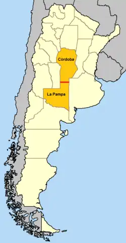
North Island, just north of Ahipara Beach, crossing through Awanui, Whangaroa Harbour, Mangonui and Butlers Point Northland, the town of Kaitaia (pop around 5,000) is 7km south of it 35°0′S 173°57′E / 35.000°S 173.950°E Pacific Ocean 35°0′S 72°11′W / 35.000°S 72.183°W ChileO'Higgins Region - passing just south of Curicó 35°0′S 70°21′W / 35.000°S 70.350°W ArgentinaThe parallel defines the border between Córdoba Province and La Pampa Province[1]
Passing just south of La Plata35°0′S 57°35′W / 35.000°S 57.583°W Atlantic Ocean Río de la Plata estuary - passing just south of Montevideo, Uruguay
Passing between Punta del Este and Isla de Lobos, Uruguay
See also
References
- ↑ Clemens, Eliza Jane McCartney (March 29, 1886). "La Plata Countries of South America". Lippincott. p. 276 – via Google Books.
Circles of latitude / meridians | |
|---|---|
45x90
45x90
45x90
45x90
|