127th meridian east
.svg.png)
127°
127th meridian east
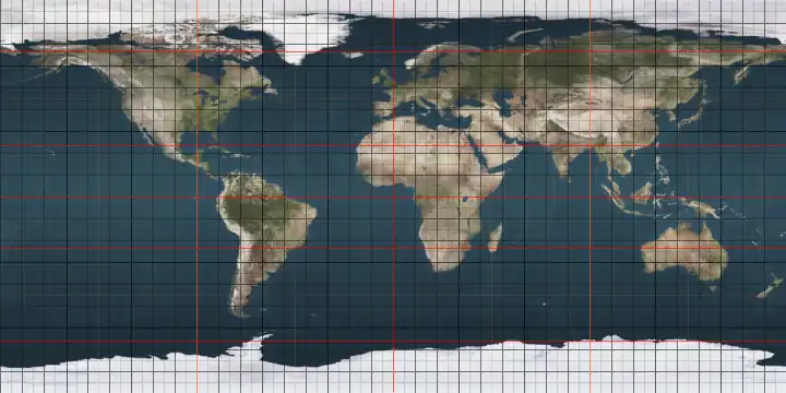
The meridian 127° east of Greenwich is a line of longitude that extends from the North Pole across the Arctic Ocean, Asia, Australia, the Indian Ocean, the Southern Ocean, and Antarctica to the South Pole.
The 127th meridian east forms a great circle with the 53rd meridian west.

World Map in outline centred on East Asia and Australia.
From Pole to Pole
Starting at the North Pole and heading south to the South Pole, the 127th meridian east passes through:
Co-ordinates Country, territory or sea Notes 90°0′N 127°0′E / 90.000°N 127.000°E Arctic Ocean 77°34′N 127°0′E / 77.567°N 127.000°E Laptev Sea 73°27′N 127°0′E / 73.450°N 127.000°E  Russia
Sakha Republic — islands of the Lena Delta and the mainland
Amur Oblast — from 55°42′N 127°0′E / 55.700°N 127.000°E51°0′N 127°0′E / 51.000°N 127.000°E  People's Republic of China
Heilongjiang
Jilin — from 45°0′N 127°0′E / 45.000°N 127.000°E
Heilongjiang — for about 10 km from 44°47′N 127°0′E / 44.783°N 127.000°E
Jilin — from 44°43′N 127°0′E / 44.717°N 127.000°E41°45′N 127°0′E / 41.750°N 127.000°E  North Korea
Jagang Province
Yanggang Province
South Hamgyeong Province
South Pyeongan Province
South Hamgyeong Province
Gangwon Province38°13′N 127°0′E / 38.217°N 127.000°E  South Korea
Gyeonggi Province
Passing through Seoul
Gyeonggi Province - Passing through of Suwon
South Chungcheong Province
North Jeolla Province - Passing just west of Jeonju
South Jeolla Province
Passing just east of Gwangju
South Jeolla Province34°18′N 127°0′E / 34.300°N 127.000°E East China Sea Passing just east of the island of Jeju-do, South Korea (at 33°27′N 126°57′E / 33.450°N 126.950°E)
Passing just west of the island of Tonakijima, Okinawa Prefecture, Japan (at 26°22′N 127°8′E / 26.367°N 127.133°E)
Passing just east of the island of Kumejima, Okinawa Prefecture, Japan (at 26°20′N 126°49′E / 26.333°N 126.817°E)25°45′N 127°0′E / 25.750°N 127.000°E Pacific Ocean Philippine Sea — passing just east of the Talaud Islands,  Indonesia (at 4°16′N 126°55′E / 4.267°N 126.917°E)
4°17′N 127°0′E / 4.283°N 127.000°E Molucca Sea Passing just west of the island of Latalata, Indonesia (at 0°16′S 127°1′E / 0.267°S 127.017°E)
Passing just west of the island of Kasiruta, Indonesia (at 0°26′S 127°5′E / 0.433°S 127.083°E)1°43′S 127°0′E / 1.717°S 127.000°E Ceram Sea 3°9′S 127°0′E / 3.150°S 127.000°E IndonesiaIsland of Buru 3°43′S 127°0′E / 3.717°S 127.000°E Banda Sea Passing just east of the island of Wetar, Indonesia (at 7°43′S 126°50′E / 7.717°S 126.833°E)
Passing just west of the island of Kisar, Indonesia (at 8°2′S 127°8′E / 8.033°S 127.133°E)8°20′S 127°0′E / 8.333°S 127.000°E  Timor-Leste
8°41′S 127°0′E / 8.683°S 127.000°E Timor Sea 13°46′S 127°0′E / 13.767°S 127.000°E .svg.png) Australia
AustraliaWestern Australia 32°18′S 127°0′E / 32.300°S 127.000°E Indian Ocean Australian authorities consider this to be part of the Southern Ocean[1][2] 60°0′S 127°0′E / 60.000°S 127.000°E Southern Ocean 66°31′S 127°0′E / 66.517°S 127.000°E Antarctica Australian Antarctic Territory, claimed by Australia
See also
References
- ↑ Darby, Andrew (22 December 2003). "Canberra all at sea over position of Southern Ocean". The Age. Archived from the original on 25 December 2018. Retrieved 13 January 2013.
- ↑ "Indian Ocean". Encyclopædia Britannica. Archived from the original on 25 December 2018. Retrieved 13 January 2013.
Circles of latitude / meridians | |
|---|---|
45x90
45x90
45x90
45x90
|
This article is issued from Wikipedia. The text is licensed under Creative Commons - Attribution - Sharealike. Additional terms may apply for the media files.