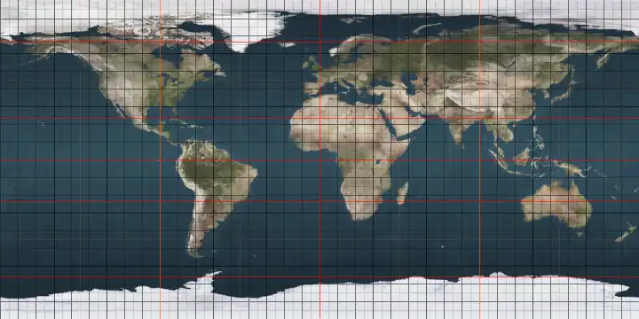
Circles of latitude between the 65th parallel north and the 70th parallel north
Following are circles of latitude between the 65th parallel north and the 70th parallel north. This includes the Arctic Circle, at 66°33′49.6″ north.
66th parallel north
.svg.png)
The 66th parallel north is a circle of latitude that is 66 degrees north of the Earth's equatorial plane, approximately 61 kilometres (38 mi) south of the Arctic Circle. It crosses the Atlantic Ocean, Europe, Asia and North America.
This latitude also roughly corresponds to the minimum latitude in which midnight sun can last all night near the summer solstice.
At this latitude midnight sun lasts from about 12 to 29 June, and the sun is visible for 2 hours, 47 minutes during the winter solstice. At midnight on the summer solstice, the altitude of the sun is 0.00°.
Around the world
Starting at the Prime Meridian and heading eastwards, the parallel 66° north passes through:
67th parallel north
The 67th parallel north is a circle of latitude that is 67 degrees north of the Earth's equatorial plane, approximately 50 km north of the Arctic Circle. It crosses the Atlantic Ocean, Europe, Asia and North America.
At this latitude midnight sun lasts from about June 1st to July 10th, and the sun is visible for 1 hour, 30 minutes during the winter solstice. At midnight on the summer solstice, the altitude of the sun is 0.85°.
If the latitude in the northern hemisphere is 67°45′ or smaller, every day in the month of March can view both astronomical dawn and astronomical dusk.
Around the world
Starting at the Prime Meridian and heading eastwards, the parallel 67° north passes through:
68th parallel north
The 68th parallel north is a circle of latitude that is 68 degrees north of the Earth's equatorial plane, in the Arctic. It crosses the Atlantic Ocean, Europe, Asia and North America.
At this latitude midnight sun lasts from about May 26th to July 16th, and civil polar twilight from about December 9th to January 3rd. At noon on the summer and winter solstices, the altitude of the sun is 45.45° and -0.7° respectively. At midnight on the summer solstice, the altitude of the sun is 1.76°.
This latitude is the boundary between the Southern and Arctic zones of Canada's National Topographic System, at which the longitude span of each map sheet doubles as one crosses this latitude going north.
Around the world
Starting at the Prime Meridian and heading eastwards, the parallel 68° north passes through:
Coordinates Country, territory or ocean Notes 68°0′N 0°0′E / 68.000°N 0.000°E Atlantic Ocean Norwegian Sea 68°0′N 13°0′E / 68.000°N 13.000°E  Norway
Moskenesøya, Lofoten, Nordland 68°0′N 13°17′E / 68.000°N 13.283°E Atlantic Ocean Vestfjorden, Norwegian Sea 68°0′N 15°4′E / 68.000°N 15.067°E NorwayEngeløya, Nordland 68°0′N 15°7′E / 68.000°N 15.117°E Atlantic Ocean Skagstadsundet, Norwegian Sea 68°0′N 15°4′E / 68.000°N 15.067°E NorwayLundøya and Finnøya, and the mainland Nordland 68°0′N 13°17′E / 68.000°N 13.283°E Atlantic Ocean Vestfjorden, Norwegian Sea 68°0′N 15°4′E / 68.000°N 15.067°E NorwayEngeløya, Lundøya and Finnøya, and the mainland Nordland 68°0′N 13°17′E / 68.000°N 13.283°E Atlantic Ocean Vestfjorden, Norwegian Sea 68°0′N 15°6′E / 68.000°N 15.100°E NorwayIslands of Engeløya, Lundøya and Finnøya, and the mainland Nordland 68°0′N 17°1′E / 68.000°N 17.017°E  Sweden
Norrbotten County (Lapland province) 68°0′N 17°48′E / 68.000°N 17.800°E NorwayNordland, for about 5,8 km 68°0′N 17°56′E / 68.000°N 17.933°E SwedenNorrbotten County (Lapland and Norrbotten provinces) 68°0′N 23°33′E / 68.000°N 23.550°E  Finland
Lapland 68°0′N 29°25′E / 68.000°N 29.417°E  Russia
Kola Peninsula, Murmansk Oblast 68°0′N 39°58′E / 68.000°N 39.967°E Arctic Ocean White Sea 68°0′N 44°14′E / 68.000°N 44.233°E RussiaKanin Peninsula, Nenets Autonomous Okrug 68°0′N 46°33′E / 68.000°N 46.550°E Arctic Ocean Barents Sea 68°0′N 49°43′E / 68.000°N 49.717°E RussiaNenets Autonomous Okrug
Komi Republic
Yamalo-Nenets Autonomous Okrug68°0′N 73°6′E / 68.000°N 73.100°E Arctic Ocean Gulf of Ob, Kara Sea 68°0′N 74°48′E / 68.000°N 74.800°E RussiaYamalo-Nenets Autonomous Okrug 68°0′N 77°12′E / 68.000°N 77.200°E Arctic Ocean Taz Estuary, Kara Sea 68°0′N 77°30′E / 68.000°N 77.500°E RussiaYamalo-Nenets Autonomous Okrug
Krasnoyarsk Krai
Yakutia
Chukotka Autonomous Okrug68°0′N 176°31′W / 68.000°N 176.517°W Arctic Ocean Chukchi Sea 68°0′N 165°15′W / 68.000°N 165.250°W .png) United States
United StatesAlaska 68°0′N 141°0′W / 68.000°N 141.000°W .svg.png) Canada
CanadaYukon
Northwest Territories
Nunavut68°0′N 115°7′W / 68.000°N 115.117°W Arctic Ocean Coronation Gulf
Passing just north of the Couper, Berens and Lawford Islands
Passing just north of Hepburn Island
Passing just south of the Jameson Islands68°0′N 110°9′W / 68.000°N 110.150°W CanadaNunavut 68°0′N 110°0′W / 68.000°N 110.000°W Arctic Ocean Bathurst Inlet 68°0′N 109°26′W / 68.000°N 109.433°W CanadaNunavut - Chapman Islands 68°0′N 109°0′W / 68.000°N 109.000°W Arctic Ocean Bathurst Inlet
Passing just north of Lewes Island
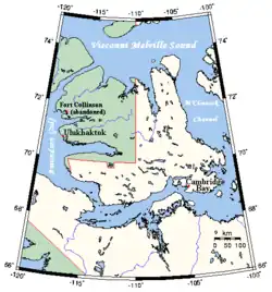
Fishers Island68°0′N 107°53′W / 68.000°N 107.883°W CanadaNunavut 68°0′N 103°17′W / 68.000°N 103.283°W Arctic Ocean Queen Maud Gulf 68°0′N 98°59′W / 68.000°N 98.983°W CanadaNunavut - O'Reilly Island, Klutschak Peninsula and Adelaide Peninsula 68°0′N 96°6′W / 68.000°N 96.100°W Arctic Ocean Chantrey Inlet 68°0′N 95°25′W / 68.000°N 95.417°W CanadaNunavut 68°0′N 88°20′W / 68.000°N 88.333°W Arctic Ocean Committee Bay 68°0′N 86°48′W / 68.000°N 86.800°W CanadaNunavut - Wales Island and Melville Peninsula 68°0′N 82°9′W / 68.000°N 82.150°W Arctic Ocean Foxe Basin 68°0′N 77°2′W / 68.000°N 77.033°W CanadaNunavut - Prince Charles Island, Air Force Island and Baffin Island 68°0′N 64°46′W / 68.000°N 64.767°W Arctic Ocean Davis Strait 68°0′N 50°20′W / 68.000°N 50.333°W  Greenland
Avannaata
Sermersooq68°0′N 31°49′W / 68.000°N 31.817°W Atlantic Ocean Greenland Sea
Norwegian Sea
69th parallel north
The 69th parallel north is a circle of latitude that is 69 degrees north of the Earth's equatorial plane, in the Arctic. It crosses the Atlantic Ocean, Europe, Asia and North America, and passes through some of the southern seas of the Arctic Ocean.
At this latitude the midnight sun lasts from about May 20th to July 22nd, and civil polar twilight from about December 1st to January 11th. At noon on the summer and winter solstices, the altitude of the sun is 44.45° and -1.52° respectively. At midnight on the summer solstice, the altitude of the sun is 2.69°.
If the latitude in northern hemisphere is 69°48′ or smaller, every day in September can view both nautical dawn and dusk. Also, if the latitude in northern hemisphere is 69°10′ or smaller, every day in April can view both civil dawn and dusk.
Around the world
Starting at the Prime Meridian and heading eastwards, the parallel 69° north passes through:
Coordinates Country, territory or sea Notes 69°0′N 0°0′E / 69.000°N 0.000°E Atlantic Ocean Norwegian Sea 69°0′N 15°0′E / 69.000°N 15.000°E NorwayIslands of Langøya, Andøya, Bjarkøya and Dyrøya, and the mainland Troms 69°0′N 20°9′E / 69.000°N 20.150°E SwedenNorrbotten County (Lapland province)
Passing 6.7 km south of the tripoint between Finland, Norway and Sweden69°0′N 20°50′E / 69.000°N 20.833°E FinlandLapland 69°0′N 22°6′E / 69.000°N 22.100°E NorwayTroms 69°0′N 25°44′E / 69.000°N 25.733°E FinlandLapland 69°0′N 28°44′E / 69.000°N 28.733°E RussiaKola Peninsula, Murmansk Oblast
Passing 5.8 km south of the tripoint between Finland, Norway and Russia
Passing northern parts of Murmansk69°0′N 36°37′E / 69.000°N 36.617°E Arctic Ocean Barents Sea 69°0′N 48°12′E / 69.000°N 48.200°E RussiaIsland of Kolguyev, Nenets Autonomous Okrug 69°0′N 50°10′E / 69.000°N 50.167°E Arctic Ocean Pechora Sea, Barents Sea 69°0′N 60°57′E / 69.000°N 60.950°E RussiaYugorsky Peninsula, Nenets Autonomous Okrug
Yamalo-Nenets Autonomous Okrug69°0′N 66°24′E / 69.000°N 66.400°E Arctic Ocean Baydaratskaya Bay, Kara Sea 69°0′N 68°26′E / 69.000°N 68.433°E RussiaYamal Peninsula, Yamalo-Nenets Autonomous Okrug 69°0′N 72°31′E / 69.000°N 72.517°E Arctic Ocean Gulf of Ob, Kara Sea 69°0′N 74°5′E / 69.000°N 74.083°E Arctic Ocean Taz Estuary, Kara Sea 69°0′N 76°58′E / 69.000°N 76.967°E RussiaYamalo-Nenets Autonomous Okrug
Krasnoyarsk Krai
Yakutia
Chukotka Autonomous Okrug69°0′N 169°24′E / 69.000°N 169.400°E Arctic Ocean Chaunskaya Bay, East Siberian Sea 69°0′N 170°54′E / 69.000°N 170.900°E RussiaChukotka Autonomous Okrug 69°0′N 179°56′E / 69.000°N 179.933°E Arctic Ocean Chukchi Sea 69°0′N 163°54′W / 69.000°N 163.900°W United StatesAlaska 69°0′N 141°0′W / 69.000°N 141.000°W CanadaYukon 69°0′N 137°28′W / 69.000°N 137.467°W Arctic Sea Mackenzie Bay, Beaufort Sea 69°0′N 136°7′W / 69.000°N 136.117°W CanadaMackenzie River delta and mainland Northwest Territories
Nunavut69°0′N 117°53′W / 69.000°N 117.883°W Arctic Sea Dolphin and Union Strait 69°0′N 115°53′W / 69.000°N 115.883°W Canada(unnamed peninsula) Nunavut 69°0′N 115°47′W / 69.000°N 115.783°W Arctic Sea Dolphin and Union Strait 69°0′N 113°33′W / 69.000°N 113.550°W CanadaVictoria Island, Nunavut 69°0′N 107°24′W / 69.000°N 107.400°W Arctic Sea Dease Strait 69°0′N 105°4′W / 69.000°N 105.067°W CanadaVictoria Island, Nunavut 69°0′N 101°48′W / 69.000°N 101.800°W Arctic Sea Victoria Strait 69°0′N 100°36′W / 69.000°N 100.600°W CanadaRoyal Geographical Society Islands, Nunavut 69°0′N 99°59′W / 69.000°N 99.983°W Arctic Sea Alexandra Strait 69°0′N 99°31′W / 69.000°N 99.517°W CanadaKing William Island, Nunavut 69°0′N 95°53′W / 69.000°N 95.883°W Arctic Sea Rae Strait 69°0′N 94°21′W / 69.000°N 94.350°W Canada(unnamed peninsula) Nunavut 69°0′N 90°40′W / 69.000°N 90.667°W Arctic Sea Pelly Bay, Gulf of Boothia 69°0′N 90°9′W / 69.000°N 90.150°W Canada(unnamed islands) Nunavut 69°0′N 89°54′W / 69.000°N 89.900°W Arctic Sea Gulf of Boothia 69°0′N 89°42′W / 69.000°N 89.700°W CanadaSimpson Peninsula, Nunavut 69°0′N 88°30′W / 69.000°N 88.500°W Arctic Sea Committee Bay, Gulf of Boothia 69°0′N 85°25′W / 69.000°N 85.417°W CanadaIslands off coast and mainland Melville Peninsula, Nunavut 69°0′N 81°30′W / 69.000°N 81.500°W Arctic Sea Foxe Basin 69°0′N 79°18′W / 69.000°N 79.300°W CanadaRowley Island, Nunavut 69°0′N 78°42′W / 69.000°N 78.700°W Arctic Sea Foxe Basin 69°0′N 76°37′W / 69.000°N 76.617°W CanadaBaffin Island, Nunavut 69°0′N 68°0′W / 69.000°N 68.000°W Arctic Sea Davis Strait 69°0′N 51°08′W / 69.000°N 51.133°W GreenlandAvannaata
Sermersooq69°0′N 25°40′W / 69.000°N 25.667°W Atlantic Ocean Greenland Sea
Norwegian Sea
Notable cities and towns on 69°N
- Cambridge Bay, Nunavut, Canada
- Tromsø, Troms, Norway
- Murmansk, Murmansk Oblast, Russia
- Norilsk, Krasnoyarsk Krai, Russia
- Pevek, Chukotka Autonomous Okrug, Russia
70th parallel north
The 70th parallel north is a circle of latitude that is 70 degrees north of the Earth's equatorial plane, in the Arctic. It crosses the Atlantic Ocean, Europe, Asia and North America, and passes through some of the southern seas of the Arctic Ocean.
At this latitude midnight sun lasts from about May 16th to July 27th, and civil polar twilight from November 25th to January 16th. At noon on the summer and winter solstices, the altitude of the sun is 43.45° and -3.04° respectively. At midnight on the summer solstice, the altitude of the sun is 3.64°.
Around the world
Starting at the Prime Meridian and heading eastwards, the parallel 70° north passes through:
See also
References
- ↑ United States. Hydrographic Office (1940). List of Lights: North sea and Arctic ocean (except British islands). Volume V. H.O. pub. U.S. Government Printing Office. p. 278. Retrieved 7 November 2024.
- ↑ Kiær, A.N.; Vibe, J.; Helland, A.; Strøm, B. (1908). Norges land og folk: Nordlands amt. Norges land og folk: statistisk og topografisk beskrevet. H. Aschehoug & Company. p. 316. Retrieved 7 November 2024.
- ↑ Nickel, P.; Valderhaug, H.J.; Harries, J.H. (2017). Norwegian Cruising Guide—Vol 3: Norway West Coast, Bergen to Bodø. Norwegian Cruising Guide (in Norwegian). Attainable Adventure Cruising Ltd. p. 238. ISBN 978-0-9958939-7-9. Retrieved 7 November 2024.
- ↑ Cornell University. Libraries (1926). Islandica. Cornell University Library. p. 26. Retrieved 7 November 2024.
Circles of latitude / meridians | |
|---|---|
45x90
45x90
45x90
45x90
|