Circles of latitude between the 40th parallel north and the 45th parallel north
Following are circles of latitude between the 40th parallel north and the 45th parallel north:
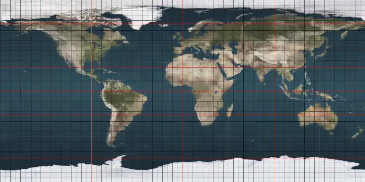
41st parallel north
.svg.png)
The 41st parallel north is a circle of latitude that is 41 degrees north of the Earth's equatorial plane. It crosses Europe, the Mediterranean Sea, Asia, the Pacific Ocean, North America, and the Atlantic Ocean.
At this latitude the sun is visible for 15 hours, 8 minutes during the summer solstice and 9 hours, 13 minutes during the winter solstice.[1]
United States
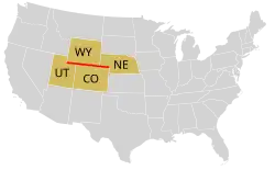
In the United States, the parallel defines the southernmost border of Wyoming (bordering Utah and Colorado), and part of the border between Nebraska and Colorado.
In 1606, King James I of England created the Colony of Virginia. In the First Virginia Charter, he gave the London Company the right to "begin their Plantation and Habitation in some fit and convenient place between four and thirty and one and forty degrees of the said latitude all alongst the coast of Virginia and coasts of America." The Jamestown Settlement was established roughly at the midpoint of that territory. The later Pilgrim (Plymouth Colony) settlers were originally bound for the northern portion of the Virginia territory. Instead, they landed north of the 41st parallel on Cape Cod, where they had exclusive rights to the land under the charter for the Plymouth Colony.[2]
As originally set by King Charles II of England in 1664, the point at which the 41st parallel crosses the Hudson River marks the northeastern border between New Jersey and New York. This border then proceeds northwest to the Tri-States Monument at the confluence of the Delaware and Neversink rivers.[3]
The 41st parallel was also one of the principal baselines used for surveying a portion of lands in Ohio. This marked the southern boundary of the Connecticut Western Reserve and the Firelands using the western boundary with Pennsylvania as the principal meridian. It also served as the baseline for a later survey of Ohio land north of the Greenville Treaty line up to the Fulton line which was the original boundary between Michigan and Ohio under the Northwest Ordinance (see the Toledo Strip). The later survey used the boundary with Indiana as the meridian.
The Union Pacific Railroad built along the 41st parallel for much of its length when building the first transcontinental railroad.[4]
Around the world
Starting at the prime meridian and heading eastwards, the parallel 41° north passes through:
42nd parallel north
The 42nd parallel north is a circle of latitude that is 42 degrees north of the Earth's equatorial plane. It crosses Europe, the Mediterranean Sea, Asia, the Pacific Ocean, North America, and the Atlantic Ocean.
At this latitude the sun is visible for 15 hours, 15 minutes during the summer solstice and 9 hours, 6 minutes during the winter solstice.[5]
The earth's rotational speed at this latitude is roughly equal to the speed of sound.
One minute of longitude along the 42nd parallel is approximately 0.7456 nautical miles (0.8580 mi; 1.381 km).
United States

The parallel 42° north forms most of the New York–Pennsylvania border, although due to imperfect surveying in 1785–1786, this boundary wanders around on both sides of the true parallel. The area around the parallel in this region is known as the Twin Tiers.
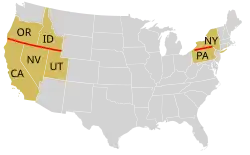
The 42nd parallel became agreed upon as the northward limit of the Spanish Empire by the Adams–Onís Treaty of 1819 with the United States, which established the parallel as the border between the Viceroyalty of New Spain of the Kingdom of Spain and the western territory of the United States of America from the meridian of the headwaters of the Arkansas River west to the Pacific Ocean.[6] The Treaty of Guadalupe Hidalgo of 1848 then ceded much of what was then northern Mexico to the United States; as a result, the northernmost U.S. states which were created from Mexican territory (California, Nevada, and Utah) have the parallel 42° north as their northern border, and the adjoining U.S. states of Oregon and Idaho have the parallel as their southern border.
Around the world
Starting at the Prime Meridian and heading eastwards, the parallel 42° north passes through:
43rd parallel north
The 43rd parallel north is a circle of latitude that is 43 degrees north of the Earth's equatorial plane. It crosses Europe, the Mediterranean Sea, Asia, the Pacific Ocean, North America, and the Atlantic Ocean.
On 21 June the sun averages, with negligible variance, its local maximum, 70.83 degrees in the sky.[7]
At this latitude the sun is visible for 15 hours, 22 minutes during the summer solstice and 9 hours, 0 minutes during the winter solstice.[8]
Around the world
Starting at the Prime Meridian and heading eastwards, the parallel 43° north passes through:
Coordinates Country, territory or sea Notes 43°0′N 0°0′E / 43.000°N 0.000°E  France
43°0′N 3°2′E / 43.000°N 3.033°E Mediterranean Sea Gulf of Lion 43°0′N 6°10′E / 43.000°N 6.167°E FranceÎles d'Hyères 43°0′N 6°14′E / 43.000°N 6.233°E Mediterranean Sea 43°0′N 9°20′E / 43.000°N 9.333°E FranceIsland of Corsica 43°0′N 9°27′E / 43.000°N 9.450°E Mediterranean Sea Passing just south of the island of Capraia,  Italy
Italy43°0′N 10°30′E / 43.000°N 10.500°E ItalyGallina
Grottammare43°0′N 13°52′E / 43.000°N 13.867°E Adriatic Sea Passing just south of the island of Vis,  Croatia
Passing just north of the island of Korčula, Croatia43°0′N 17°2′E / 43.000°N 17.033°E Croatia43°0′N 17°40′E / 43.000°N 17.667°E  Bosnia and Herzegovina
43°0′N 18°28′E / 43.000°N 18.467°E  Montenegro
43°0′N 20°6′E / 43.000°N 20.100°E  Serbia
43°0′N 20°34′E / 43.000°N 20.567°E  Kosovo or Serbia
Kosovo is a partially recognised state. Some nations consider its territory to be part of Serbia. 43°0′N 21°14′E / 43.000°N 21.233°E Serbiapassing through Leskovac 43°0′N 22°49′E / 43.000°N 22.817°E  Bulgaria
43°0′N 27°54′E / 43.000°N 27.900°E Black Sea 43°0′N 40°56′E / 43.000°N 40.933°E  Abkhazia or
  Georgia
Abkhazia is a partially recognised state. Most nations consider its territory to be part of Georgia. Passing through Sokhumi.
43°0′N 41°54′E / 43.000°N 41.900°E Georgia43°0′N 43°5′E / 43.000°N 43.083°E  Russia
Passing through Vladikavkaz and Makhachkala 43°0′N 47°28′E / 43.000°N 47.467°E Caspian Sea 43°0′N 51°46′E / 43.000°N 51.767°E  Kazakhstan
43°0′N 56°0′E / 43.000°N 56.000°E  Uzbekistan
43°0′N 65°46′E / 43.000°N 65.767°E Kazakhstanpassing just north of Taraz 43°0′N 73°33′E / 43.000°N 73.550°E  Kyrgyzstan
passing just north of Bishkek 43°0′N 74°43′E / 43.000°N 74.717°E Kazakhstan43°0′N 80°23′E / 43.000°N 80.383°E  People's Republic of China
Xinjiang 43°0′N 96°10′E / 43.000°N 96.167°E  Mongolia
43°0′N 110°40′E / 43.000°N 110.667°E People's Republic of ChinaInner Mongolia
Liaoning
Jilin (for about 26 km)
Liaoning (for about 14 km)
Jilin43°0′N 129°53′E / 43.000°N 129.883°E  North Korea
For about 5 km (county of Onsong) 43°0′N 129°57′E / 43.000°N 129.950°E People's Republic of ChinaJilin 43°0′N 131°6′E / 43.000°N 131.100°E RussiaPrimorsky Krai — passing just south of Vladivostok 43°0′N 131°34′E / 43.000°N 131.567°E Sea of Japan Amur Bay 43°0′N 131°47′E / 43.000°N 131.783°E RussiaRussky Island 43°0′N 131°56′E / 43.000°N 131.933°E Sea of Japan Ussuri Bay 43°0′N 132°19′E / 43.000°N 132.317°E Russia43°0′N 134°7′E / 43.000°N 134.117°E Sea of Japan 43°0′N 140°31′E / 43.000°N 140.517°E  Japan
JapanIsland of Hokkaidō — passing just south of Sapporo 43°0′N 145°1′E / 43.000°N 145.017°E Pacific Ocean 43°0′N 124°28′W / 43.000°N 124.467°W .png) United States
United StatesOregon - passing just north of Crater Lake
Idaho
Wyoming
South Dakota / Nebraska border
South Dakota
Iowa
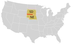
Wisconsin — passing south of Madison and through MilwaukeeThe parallel 43° north forms most of the boundary between the State of Nebraska and the State of South Dakota. The parallel formed the northern border of the historic and extralegal Territory of Jefferson.
43°0′N 87°53′W / 43.000°N 87.883°W Lake Michigan 43°0′N 86°13′W / 43.000°N 86.217°W United StatesMichigan - Passing through Grand Rapids and Flint 43°0′N 82°25′W / 43.000°N 82.417°W .svg.png) Canada
CanadaOntario — passing through the cities of Sarnia, London, and Welland 43°0′N 79°1′W / 43.000°N 79.017°W United StatesNew York - Passing through the University at Buffalo and Syracuse
Vermont
New Hampshire - passing through Manchester43°0′N 70°45′W / 43.000°N 70.750°W Atlantic Ocean 43°0′N 9°15′W / 43.000°N 9.250°W  Spain
SpainCee (province of A Coruña), Galiza
passing through Lugo, Galiza
Reinosa, Cantabria43°0′N 1°4′W / 43.000°N 1.067°W France
44th parallel north
The 44th parallel north is a circle of latitude that is 44 degrees north of the Earth's equatorial plane. It crosses Europe, the Mediterranean Sea, Asia, the Pacific Ocean, North America, and the Atlantic Ocean.
At this latitude, astronomically, the sun is visible circa 15 hours 29 minutes before the dawn during the summer solstice and 8 hours, 53 minutes during the winter solstice.[9]
Around the world
Starting at the Prime Meridian and heading eastwards, the parallel 44° north passes through:
Coordinates Country, territory or sea Notes 44°0′N 0°0′E / 44.000°N 0.000°E FrancePassing through Montauban 44°0′N 7°39′E / 44.000°N 7.650°E Italy44°0′N 8°10′E / 44.000°N 8.167°E Mediterranean Sea Gulf of Genoa 44°0′N 10°6′E / 44.000°N 10.100°E ItalyPassing just north of  San Marino
44°0′N 12°40′E / 44.000°N 12.667°E Adriatic Sea 44°0′N 15°2′E / 44.000°N 15.033°E CroatiaIslands of Dugi Otok, Pašman, and the mainland 44°0′N 16°32′E / 44.000°N 16.533°E Bosnia and Herzegovina44°0′N 19°14′E / 44.000°N 19.233°E SerbiaFor about 3 km 44°0′N 19°16′E / 44.000°N 19.267°E Bosnia and Herzegovina44°0′N 19°34′E / 44.000°N 19.567°E SerbiaPassing through Kragujevac 44°0′N 22°25′E / 44.000°N 22.417°E BulgariaPassing through Vidin 44°0′N 22°55′E / 44.000°N 22.917°E  Romania
Passing just north of Alexandria 44°0′N 26°13′E / 44.000°N 26.217°E Bulgaria44°0′N 27°41′E / 44.000°N 27.683°E RomaniaFor about 15 km 44°0′N 27°53′E / 44.000°N 27.883°E BulgariaFor about 4 km 44°0′N 27°56′E / 44.000°N 27.933°E Romania44°0′N 28°40′E / 44.000°N 28.667°E Black Sea 44°0′N 39°11′E / 44.000°N 39.183°E RussiaPassing just south of Pyatigorsk 44°0′N 47°23′E / 44.000°N 47.383°E Caspian Sea Passing just north of Chechen Island, Russia44°0′N 50°55′E / 44.000°N 50.917°E Kazakhstan44°0′N 56°0′E / 44.000°N 56.000°E Uzbekistan44°0′N 61°26′E / 44.000°N 61.433°E Kazakhstan44°0′N 80°27′E / 44.000°N 80.450°E People's Republic of ChinaXinjiang — passing about 22 km north of Ürümqi 44°0′N 95°30′E / 44.000°N 95.500°E Mongolia44°0′N 111°50′E / 44.000°N 111.833°E People's Republic of ChinaInner Mongolia
Jilin — passing just north of Changchun
Heilongjiang
Jilin - for about 2 km
Heilongjiang - for <1 km
Jilin - for about 10 km
Heilongjiang
Jilin - for about 5 km
Heilongjiang44°0′N 131°15′E / 44.000°N 131.250°E Russia44°0′N 135°32′E / 44.000°N 135.533°E Sea of Japan 44°0′N 141°39′E / 44.000°N 141.650°E JapanIsland of Hokkaidō:
— Hokkaidō Prefecture44°0′N 144°17′E / 44.000°N 144.283°E Sea of Okhotsk 44°0′N 144°54′E / 44.000°N 144.900°E JapanIsland of Hokkaidō:
— Hokkaidō Prefecture - Shiretoko Peninsula44°0′N 145°10′E / 44.000°N 145.167°E Nemuro Strait 44°0′N 145°39′E / 44.000°N 145.650°E Kuril Islands Kunashir Island, administered by Russia but claimed by Japan44°0′N 145°48′E / 44.000°N 145.800°E Pacific Ocean Passing just north of the island of Shikotan, administered by Russia, claimed by Japan44°0′N 124°8′W / 44.000°N 124.133°W United StatesOregon - passing just south of Eugene and Bend 44th parallel in Wisconsin, United States
Idaho
Wyoming
South Dakota - passing just south of Rapid City
Minnesota - passing through Rochester
Wisconsin - passing through Oshkosh44°0′N 87°41′W / 44.000°N 87.683°W Lake Michigan 44°0′N 86°28′W / 44.000°N 86.467°W United StatesMichigan 44°0′N 83°59′W / 44.000°N 83.983°W Lake Huron Saginaw Bay – territorial waters of the United States 44°0′N 83°00′W / 44.000°N 83.000°W United StatesMichigan – Northern Tip of The Thumb 44°0′N 82°45′W / 44.000°N 82.750°W Lake Huron 44°0′N 81°44′W / 44.000°N 81.733°W CanadaOntario – passing through Aurora, rural Oshawa, and Picton in Prince Edward County 44°0′N 77°0′W / 44.000°N 77.000°W Lake Ontario 44°0′N 76°16′W / 44.000°N 76.267°W United StatesNew York - passing just north of Watertown
Vermont - passing through Middlebury
New Hampshire
Maine - passing just south of Auburn44°0′N 69°8′W / 44.000°N 69.133°W Atlantic Ocean Gulf of Maine - passing just south of Vinalhaven Island and Isle au Haut, Maine, United States44°0′N 66°9′W / 44.000°N 66.150°W CanadaNova Scotia 44°0′N 64°40′W / 44.000°N 64.667°W Atlantic Ocean 44°0′N 59°46′W / 44.000°N 59.767°W CanadaNova Scotia - Sable Island 44°0′N 59°45′W / 44.000°N 59.750°W Atlantic Ocean 44°0′N 1°21′W / 44.000°N 1.350°W France
45th parallel north
The 45th parallel north is a circle of latitude that is 45 degrees north of Earth's equator. It crosses Europe, Asia, the Pacific Ocean, North America, and the Atlantic Ocean. The 45th parallel north is often called the halfway point between the equator and the North Pole, but the true halfway point is 16.0 km (9.9 mi) north of it (approximately between 45°08'36" and 45°08'37") because Earth is an oblate spheroid; that is, it bulges at the equator and is flattened at the poles.[10]
At this latitude, the sun is visible for 15 hours 37 minutes during the summer solstice, and 8 hours 46 minutes during the winter solstice. The midday Sun stands 21.6° above the southern horizon at the December solstice, 68.4° at the June solstice, and exactly 45.0° at either equinox.[11]
Around the world
Starting at the Prime Meridian and heading eastwards, the parallel 45° north passes through:
Coordinates Country, territory
or seaNotes 45°0′N 0°0′E / 45.000°N 0.000°E FranceAquitaine
Midi-Pyrénées
Limousin
Auvergne
Rhône-Alpes – passing just south of Grenoble45°0′N 6°44′E / 45.000°N 6.733°E ItalyPiedmont – passing just south of Turin
Lombardy - passing by Voghera and Mantua
Emilia-Romagna – passing just south of Piacenza
Lombardy
Veneto – passing just south of Rovigo45°0′N 12°27′E / 45.000°N 12.450°E Adriatic Sea Gulf of Venice 45°0′N 13°44′E / 45.000°N 13.733°E CroatiaIstrian Peninsula, islands of Cres and Krk, and the mainland again 45°0′N 15°46′E / 45.000°N 15.767°E Bosnia and Herzegovina45°0′N 18°44′E / 45.000°N 18.733°E Croatia45°0′N 19°6′E / 45.000°N 19.100°E SerbiaPassing through the centre of Ruma and through northern part of Sremska Mitrovica
Passing through the northern edge of Stara Pazova, 30 kilometres NW of Belgrade45°0′N 21°24′E / 45.000°N 21.400°E RomaniaPassing just north of Ploiești and just south of Târgu Jiu and Râmnicu Vâlcea 45°0′N 29°39′E / 45.000°N 29.650°E Black Sea 45°0′N 33°36′E / 45.000°N 33.600°E Crimea Controlled by Russia, claimed by  Ukraine – passing just north of Simferopol, and just south of Feodosiya
45°0′N 35°24′E / 45.000°N 35.400°E Black Sea 45°0′N 37°13′E / 45.000°N 37.217°E RussiaPassing just south of Krasnodar, and just south of Stavropol 45°0′N 47°15′E / 45.000°N 47.250°E Caspian Sea 45°0′N 51°4′E / 45.000°N 51.067°E KazakhstanMangystau Province 45°0′N 56°0′E / 45.000°N 56.000°E UzbekistanKarakalpakstan (autonomous republic) – including Vozrozhdeniya Island in the Aral Sea 45°0′N 59°50′E / 45.000°N 59.833°E KazakhstanKyzylorda Province
South Kazakhstan Province
Zhambyl Province
Almaty Province45°0′N 80°2′E / 45.000°N 80.033°E People's Republic of ChinaXinjiang – passing through a 45×90 point (halfway between the North Pole and the Equator, and halfway between the Prime Meridian and the 180th meridian) 45°0′N 93°13′E / 45.000°N 93.217°E MongoliaGovi-Altai Province
Bayankhongor Province
Övörkhangai Province
Dundgovi Province
Dornogovi Province45°0′N 111°46′E / 45.000°N 111.767°E People's Republic of ChinaInner Mongolia 45°0′N 112°31′E / 45.000°N 112.517°E MongoliaSükhbaatar Province 45°0′N 114°7′E / 45.000°N 114.117°E People's Republic of ChinaInner Mongolia
Jilin
Heilongjiang45°0′N 131°30′E / 45.000°N 131.500°E RussiaPrimorsky Krai - passing through Lake Khanka 45°0′N 136°37′E / 45.000°N 136.617°E Sea of Japan Passing just south of Rishiri Island, Japan45°0′N 141°41′E / 45.000°N 141.683°E JapanHokkaidō - Horonobe, Hokkaido, Japan45°0′N 142°32′E / 45.000°N 142.533°E Sea of Okhotsk 45°0′N 147°31′E / 45.000°N 147.517°E Kuril Islands Island of Iturup, administered by Russia, claimed by Japan45°0′N 147°59′E / 45.000°N 147.983°E Pacific Ocean 45°0′N 124°1′W / 45.000°N 124.017°W United StatesOregon – passing north of Lincoln City and Salem, and south of North Powder
Idaho – passing north of New Meadows, through Brundage Mountain ski area, and south of Salmon
Montana – passing through Clark Canyon Dam (south of Dillon)
Montana / Wyoming border
South Dakota – passing through Eagle Butte and Watertown
Minnesota – passing through northern Minneapolis and northern suburbs of St Paul
Wisconsin – passing north of Chippewa Falls and near Wausau (at a 45×90 point, halfway between the North Pole and Equator, halfway between the Prime Meridian and 180th meridian, at Rietbrock).45°0′N 87°37′W / 45.000°N 87.617°W Lake Michigan Green Bay – territorial waters of the United States 45°0′N 87°21′W / 45.000°N 87.350°W United StatesWisconsin – passing across northern Door Peninsula, south of Baileys Harbor 45°0′N 87°9′W / 45.000°N 87.150°W Lake Michigan Territorial waters of the United States 45°0′N 86°9′W / 45.000°N 86.150°W United StatesMichigan – South Manitou Island 45°0′N 86°5′W / 45.000°N 86.083°W Lake Michigan Territorial waters of the United States 45°0′N 85°46′W / 45.000°N 85.767°W United StatesMichigan – Leelanau Peninsula (Leelanau County) 45°0′N 86°5′W / 45.000°N 86.083°W Lake Michigan Grand Traverse Bay – territorial waters of the United States 45°0′N 85°47′W / 45.000°N 85.783°W United StatesMichigan – passing through southern Gaylord and south of Alpena 45°0′N 83°26′W / 45.000°N 83.433°W Lake Huron Territorial waters of the United States and Canada 45°0′N 81°27′W / 45.000°N 81.450°W CanadaOntario – Bruce Peninsula 45°0′N 81°11′W / 45.000°N 81.183°W Lake Huron Georgian Bay – territorial waters of Canada 45°0′N 79°59′W / 45.000°N 79.983°W CanadaOntario – passing south of Bala, through Browning Island in Lake Muskoka, south of Bracebridge and south of Kemptville 45°0′N 74°54′W / 45.000°N 74.900°W United StatesNew York state – for about six miles (10 km) 45°0′N 74°46′W / 45.000°N 74.767°W CanadaOntario – Cornwall Island
Quebec – running just north of the border with New York, United States45°0′N 73°54′W / 45.000°N 73.900°W United StatesNew York – running just south of the border with Quebec, Canada
Vermont – running just south of the border with Quebec, Canada
New Hampshire – passing through Stewartstown
Maine – passing just south of Dexter45°0′N 67°4′W / 45.000°N 67.067°W Passamaquoddy Bay 45°0′N 67°0′W / 45.000°N 67.000°W CanadaDeer Island, New Brunswick 45°0′N 66°57′W / 45.000°N 66.950°W Bay of Fundy Territorial waters of Canada 45°0′N 65°10′W / 45.000°N 65.167°W CanadaNova Scotia – passing just north of Fort Edward 45°0′N 61°57′W / 45.000°N 61.950°W Atlantic Ocean 45°0′N 1°12′W / 45.000°N 1.200°W FranceAquitaine – passing just north of Bordeaux
See also
- Circles of latitude between the 35th parallel north and the 40th parallel north
- Circles of latitude between the 45th parallel north and the 50th parallel north
- The Twin Tiers region of New York and Pennsylvania
- The "Jefferson" region of Oregon and California
References
- ↑ "Duration of Daylight/Darkness Table for One Year". U.S. Naval Observatory. 2019-09-24. Archived from the original on 2019-10-12. Retrieved 2021-03-10.
- ↑ "Boundaries and Charters of Virginia".
- ↑ Graff, Bill (Summer 2006). "Sentinels at the Northern Border" (PDF). Unearthing New Jersey Vol. 2, No. 2. New Jersey Geological Survey.
- ↑ Goetzmann, William H. (1959). Army Exploration in the American West, 1803-1863. New Haven, Conn.: Yale University Press. pp. 286–287.
- ↑ "Duration of Daylight/Darkness Table for One Year". U.S. Naval Observatory. 2019-09-24. Archived from the original on 2019-10-12. Retrieved 2021-03-10.
- ↑ Nugent, Walter (2008). Habits of Empire: A History of American Expansion. Alfred A. Knopf. pp. 161, 166–167. ISBN 978-1-4000-4292-0.
- ↑ See declination of the Sun
- ↑ "Duration of Daylight/Darkness Table for One Year". U.S. Naval Observatory. 2019-09-24. Archived from the original on 2019-10-12. Retrieved 2021-03-10.
- ↑ "Duration of Daylight/Darkness Table for One Year". U.S. Naval Observatory. 2019-09-24. Archived from the original on 2019-10-12. Retrieved 2021-03-10.
- ↑ "The Half-Way to the Pole Line". 2 May 2006. Archived from the original on 2 May 2006. Retrieved 16 July 2018.
- ↑ "Duration of Daylight/Darkness Table for One Year". U.S. Naval Observatory. 2019-09-24. Archived from the original on 2019-10-12. Retrieved 2021-03-10.
Circles of latitude / meridians | |
|---|---|
45x90
45x90
45x90
45x90
|