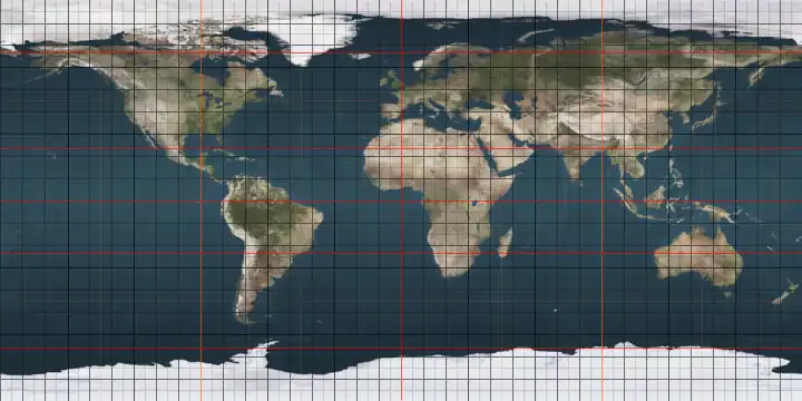
Circles of latitude between the Equator and the 5th parallel south
Following are circles of latitude between the Equator and the 5th parallel south:
1st parallel south
.svg.png)
The 1st parallel south is a circle of latitude that is 1 degree (69.2 miles/111.36 kilometers) south of the Earth's equatorial plane. It crosses the Atlantic Ocean, Africa, the Indian Ocean, Southeast Asia, Australasia, the Pacific Ocean and South America.
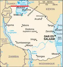
The parallel defines most of the border between Uganda and Tanzania, and a very short section of the border between Kenya and Tanzania.[1]
Around the world
Starting at the Prime Meridian and heading eastwards, the parallel 1° south passes through:
Coordinates Country, territory or sea Notes 1°0′S 0°0′E / 1.000°S 0.000°E Atlantic Ocean 1°0′S 8°52′E / 1.000°S 8.867°E  Gabon
Gabon1°0′S 14°25′E / 1.000°S 14.417°E  Republic of the Congo
1°0′S 17°20′E / 1.000°S 17.333°E  Democratic Republic of the Congo
1°0′S 29°35′E / 1.000°S 29.583°E  Uganda
1°0′S 30°45′E / 1.000°S 30.750°E Uganda /  Tanzania border
Mostly in Lake Victoria 1°0′S 33°56′E / 1.000°S 33.933°E  Kenya / Tanzania border
A short section of the border (about 11 km (6.8 mi)), entirely within Lake Victoria 1°0′S 34°1′E / 1.000°S 34.017°E KenyaPassing about 30 km (19 mi) north of the capital, Nairobi 1°0′S 41°7′E / 1.000°S 41.117°E  Somalia
1°0′S 42°2′E / 1.000°S 42.033°E Indian Ocean Passing just south of Addu Atoll,  Maldives[2]
1°0′S 98°39′E / 1.000°S 98.650°E  Indonesia
Island of Siberut 1°0′S 98°56′E / 1.000°S 98.933°E Mentawai Strait 1°0′S 100°21′E / 1.000°S 100.350°E IndonesiaIsland of Sumatra - passing just south of Padang 1°0′S 103°59′E / 1.000°S 103.983°E Karimata Strait 1°0′S 109°27′E / 1.000°S 109.450°E IndonesiaIslands of Maya Karimata and Borneo
West Kalimantan
Central Kalimantan
East Kalimantan
Passing just south of Nusantara (at 0°58′23″S 116°42′31″E / 0.97306°S 116.70861°E)1°0′S 117°8′E / 1.000°S 117.133°E Makassar Strait 1°0′S 119°28′E / 1.000°S 119.467°E IndonesiaIsland of Sulawesi 1°0′S 120°30′E / 1.000°S 120.500°E Gulf of Tomini 1°0′S 121°23′E / 1.000°S 121.383°E IndonesiaIsland of Sulawesi 1°0′S 122°47′E / 1.000°S 122.783°E Banda Sea 1°0′S 123°12′E / 1.000°S 123.200°E IndonesiaIsland of Sulawesi 1°0′S 123°22′E / 1.000°S 123.367°E Molucca Sea 1°0′S 128°19′E / 1.000°S 128.317°E IndonesiaIsland of Damar 1°0′S 128°24′E / 1.000°S 128.400°E Halmahera Sea 1°0′S 130°38′E / 1.000°S 130.633°E IndonesiaIslands of Salawati and New Guinea 1°0′S 134°3′E / 1.000°S 134.050°E Cenderawasih Bay 1°0′S 134°48′E / 1.000°S 134.800°E IndonesiaIsland of Numfor 1°0′S 134°57′E / 1.000°S 134.950°E Cenderawasih Bay 1°0′S 135°48′E / 1.000°S 135.800°E IndonesiaIsland of Biak 1°0′S 136°8′E / 1.000°S 136.133°E Pacific Ocean Passing just north of the atolls of Pelleluhu and Heina,  Papua New Guinea
Passing just south of the Kaniet Islands, Papua New Guinea
Passing just south of Banaba Island, Kiribati
Passing between the atolls of Nonouti and Tabiteuea, Kiribati1°0′S 91°26′W / 1.000°S 91.433°W  Ecuador
Island of Isabela 1°0′S 91°4′W / 1.000°S 91.067°W Pacific Ocean Passing just south of the island of San Cristóbal, Ecuador1°0′S 80°51′W / 1.000°S 80.850°W EcuadorPassing just south of Manta 1°0′S 75°23′W / 1.000°S 75.383°W  Peru
Peru1°0′S 74°16′W / 1.000°S 74.267°W  Colombia
1°0′S 69°25′W / 1.000°S 69.417°W  Brazil
Amazonas
Roraima
Amazonas
Pará
Amapá
Maranhão
Pará - islands of Grande do Gurupá and Marajó, and the mainland1°0′S 46°11′W / 1.000°S 46.183°W Atlantic Ocean
2nd parallel south
The 2nd parallel south is a circle of latitude that is 2 degrees south of the Earth's equatorial plane. It crosses the Atlantic Ocean, Africa, the Indian Ocean, Southeast Asia, Australasia, the Pacific Ocean and South America.
Under this latitude, the illumination time at the summer solstice is 12 hours and 14 minutes, and the illumination time at the winter solstice is 12 hours and 0 minutes[3]
At 2° south latitude, one degree of longitude is equivalent to 111.252 km.[4]
Around the world
Starting at the prime meridian and heading eastwards, the parallel 2° south passes through:
3rd parallel south
The 3rd parallel south is a circle of latitude that is 3 degrees south of the Earth's equatorial plane. It crosses the Atlantic Ocean, Africa, the Indian Ocean, Southeast Asia, Australasia, the Pacific Ocean and South America.
Around the world
Starting at the Prime Meridian and heading eastwards, the parallel 3° south passes through:
4th parallel south
The 4th parallel south is a circle of latitude that is 4 degrees south of the Earth's equatorial plane. It crosses the Atlantic Ocean, Africa, the Indian Ocean, Southeast Asia, Australasia, the Pacific Ocean and South America.
Around the world
Starting at the Prime Meridian and heading eastwards, the parallel 4° south passes through:
5th parallel south
The 5th parallel south is a circle of latitude that is 5 degrees south of the Earth's equatorial plane. It crosses the Atlantic Ocean, Africa, the Indian Ocean, Southeast Asia, Australasia, the Pacific Ocean and South America.
Around the world
Starting at the Prime Meridian and heading eastwards, the parallel 5° south passes through:
Co-ordinates Country, territory or sea Notes 5°0′S 0°0′E / 5.000°S 0.000°E Atlantic Ocean 5°0′S 11°59′E / 5.000°S 11.983°E Republic of the CongoFor about 7 km 5°0′S 12°2′E / 5.000°S 12.033°E  Angola
Cabinda exclave 5°0′S 12°38′E / 5.000°S 12.633°E Democratic Republic of the Congo5°0′S 29°7′E / 5.000°S 29.117°E Lake Tanganyika 5°0′S 29°46′E / 5.000°S 29.767°E Tanzania5°0′S 39°8′E / 5.000°S 39.133°E Indian Ocean Pemba Channel 5°0′S 39°40′E / 5.000°S 39.667°E TanzaniaIsland of Pemba 5°0′S 39°52′E / 5.000°S 39.867°E Indian Ocean Passing through the Amirante Islands,  Seychelles
Passing just south of Mahé island, Seychelles
Passing just north of Peros Banhos atoll, British Indian Ocean Territory
5°0′S 103°45′E / 5.000°S 103.750°E IndonesiaIsland of Sumatra 5°0′S 105°52′E / 5.000°S 105.867°E Java Sea Passing close by several small islands of Indonesia5°0′S 119°28′E / 5.000°S 119.467°E IndonesiaIsland of Sulawesi 5°0′S 120°18′E / 5.000°S 120.300°E Banda Sea Gulf of Boni - passing just north of the island of Kabaena, Indonesia5°0′S 122°23′E / 5.000°S 122.383°E IndonesiaIslands of Muna and Buton 5°0′S 122°57′E / 5.000°S 122.950°E Banda Sea Passing close by several small islands of Indonesia5°0′S 137°15′E / 5.000°S 137.250°E IndonesiaIsland of New Guinea 5°0′S 141°0′E / 5.000°S 141.000°E Papua New GuineaIsland of New Guinea 5°0′S 145°47′E / 5.000°S 145.783°E Pacific Ocean Bismarck Sea, passing close by several small islands of Papua New Guinea5°0′S 151°15′E / 5.000°S 151.250°E Papua New GuineaIsland of New Britain 5°0′S 151°57′E / 5.000°S 151.950°E Pacific Ocean Solomon Sea
- Passing just south of the island of New Ireland, Papua New Guinea
- Passing just north of Buka Island, Papua New Guinea
An unnamed part of the ocean
- Passing just north of Ontong Java Atoll, Solomon Islands
- Passing just south of Nikumaroro atoll, Kiribati5°0′S 81°4′W / 5.000°S 81.067°W PeruPiura 5°0′S 79°3′W / 5.000°S 79.050°W EcuadorFor about 4 km at the southernmost point of the country 5°0′S 79°0′W / 5.000°S 79.000°W PeruCajamarca
Amazonas
Loreto5°0′S 72°35′W / 5.000°S 72.583°W BrazilAmazonas
Pará
Maranhão
Piauí
Ceará
Rio Grande do Norte5°0′S 36°50′W / 5.000°S 36.833°W Atlantic Ocean
See also
References
- ↑ Médard, H. (1 May 2019). ""The Kagera River and the Making of a Contested Boundary: Territorial Legacies and Colonial Demarcations in Buganda (19th–20th Centuries) " with Ikram Kidari". The International Journal of African Historical Studies. 52: 11–30.
- ↑ Karan, P.P.; Subbiah, S.P.; Gilbreath, D. (2011). The Indian Ocean Tsunami: The Global Response to a Natural Disaster. University Press of Kentucky. p. 129. ISBN 978-0-8131-2652-4. Retrieved 13 November 2024.
- ↑ アメリカ海軍天文台. "Duration of Daylight/Darkness Table for One Year". Archived from the original on October 15, 2007. Retrieved 2013-06-28.
- ↑ "Length of a Degree of Latitude and Longitude". National Geospatial-Intelligence Agency. Retrieved 2009-01-21.
Circles of latitude / meridians | |
|---|---|
45x90
45x90
45x90
45x90
|