Nishapur County
Nishapur County
Persian: شهرستان نیشاپور | |
|---|---|
 Mount Binalud, located within the county | |
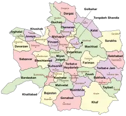 Location of Nishapur County in Razavi Khorasan province (top left, pink) | |
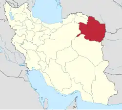 Location of Razavi Khorasan province in Iran | |
| Coordinates: 36°25′N 58°40′E / 36.417°N 58.667°E[1] | |
| Country | Iran |
| Province | Razavi Khorasan |
| Named after | Shapur I |
| Capital | Nishapur |
| Districts | Central, Sarvelayat |
| Area | |
• Total | 5,653 km2 (2,183 sq mi) |
| Population (2016)[2] | |
• Total | 451,780 |
| • Density | 80/km2 (210/sq mi) |
| Demonym | Neyshaburi |
| Time zone | UTC+3:30 (IRST) |
| Nishapur County at GEOnet Names Server | |
Nishapur County (Persian: شهرستان نیشاپور)[a] is in Razavi Khorasan province, Iran. Its capital is the city of Nishapur,[3] the second largest city in the province and the third largest city in Eastern Iran.
History
Nishapur massacre by the Mongols
The Nishapur massacre by the Mongols took place at Nishapur in April of 1221. The Mongol armies of Genghis Khan massacred the entire population of the area, which some estimates put at 1,747,000 citizens.[4]
Administrative changes
After the 2006 National Census, Binalud Rural District was separated from Takht-e Jolgeh District to join the Central District. Taghenkuh and Takht-e Jolgeh Districts were separated from the county in the establishment of Takht-e Jolgeh County.[b] In addition, the village of Bar was elevated to the status of a city.[6]
After the 2016 census, Zeberkhan District was separated from the county in the establishment of Zeberkhan County.[7] Additionally, Miyan Jolgeh District[c] was separated from the county to establish Miyan Jolgeh County and renamed the Central District.[8]
Demographics
Population
At the time of the 2006 census, the county's population was 441,184 in 118,214 households.[9] The following census in 2011 counted 433,105 people in 128,969 households.[10] The 2016 census measured the population of the county as 451,780 in 142,545 households.[2]
Administrative divisions
Nishapur County's population history and administrative structure over three consecutive censuses are shown in the following table.
| Administrative Divisions | 2006[9] | 2011[10] | 2016[2] |
|---|---|---|---|
| Central District | 274,700 | 319,576 | 341,182 |
| Binalud RD | 5,742 | 5,635 | |
| Darbqazi RD | 10,411 | 9,854 | 9,528 |
| Fazl RD | 15,323 | 17,121 | 15,792 |
| Mazul RD | 30,375 | 34,718 | 33,791 |
| Rivand RD | 12,619 | 8,835 | 8,296 |
| Bar (city) | 4,121 | 3,765 | |
| Nishapur (city) | 205,972 | 239,185 | 264,375 |
| Miyan Jolgeh District[d] | 37,117 | 38,478 | 39,288 |
| Belharat RD | 11,677 | 11,896 | 12,074 |
| Eshqabad RD | 15,280 | 15,711 | 16,270 |
| Ghazali RD | 8,835 | 8,988 | 8,951 |
| Eshqabad (city) | 1,325 | 1,883 | 1,993 |
| Sarvelayat District | 17,962 | 17,445 | 14,664 |
| Barzanun RD | 6,032 | 5,693 | 4,764 |
| Sarvelayat RD | 10,567 | 9,918 | 8,519 |
| Chekneh (city) | 1,363 | 1,834 | 1,381 |
| Taghenkuh District[e] | 22,562 | ||
| Taghenkuh-e Jonubi RD | 6,876 | ||
| Taghenkuh-e Shomali RD[f] | 15,686 | ||
| Takht-e Jolgeh District[e] | 34,267 | ||
| Binalud RD | 7,006 | ||
| Firuzeh RD | 9,292 | ||
| Takht-e Jolgeh RD | 13,063 | ||
| Firuzeh (city)[g] | 4,906 | ||
| Zeberkhan District[h] | 54,576 | 57,606 | 56,635 |
| Eshaqabad RD | 10,110 | 10,623 | 11,234 |
| Ordughesh RD | 9,788 | 8,556 | 8,174 |
| Zeberkhan RD | 14,762 | 15,149 | 14,965 |
| Darrud (city) | 4,979 | 5,449 | 5,717 |
| Kharv (city) | 11,931 | 14,115 | 13,535 |
| Qadamgah (city) | 3,006 | 3,714 | 3,010 |
| Total | 441,184 | 433,105 | 451,780 |
| RD = Rural District | |||
See also
![]() Media related to Nishapur County at Wikimedia Commons
Media related to Nishapur County at Wikimedia Commons
Notes
- ↑ Romanized as Šahrestâne Neyšhâpur; officially Šahrestâne Neyšhâbur (شهرستان نیشابور), translated as Neyshabur County
- ↑ Renamed Firuzeh County[5]
- ↑ Renamed the Central District of Miyan Jolgeh County[8]
- ↑ Transferred to Miyan Jolgeh County after the 2016 census and renamed the Central District[8]
- 1 2 Transferred to Takht-e Jolgeh County,[6] renamed Firuzeh County[5]
- ↑ Formerly Taghenkuh Rural District[11]
- ↑ Formerly the village of Bozghan[12]
- ↑ Transferred to Zeberkhan County after the 2016 census[7]
References
- ↑ OpenStreetMap contributors (3 November 2024). "Nishapur County" (Map). OpenStreetMap (in Persian). Retrieved 3 November 2024.
- 1 2 3 Census of the Islamic Republic of Iran, 1395 (2016): Razavi Khorasan Province. amar.org.ir (Report) (in Persian). The Statistical Center of Iran. Archived from the original (Excel) on 2 April 2022. Retrieved 19 December 2022.
- ↑ Habibi, Hassan (c. 2015) [Approved 21 June 1369]. Approval of the organization and chain of citizenship of the elements and units of the divisions of Khorasan province, centered in Mashhad. rc.majlis.ir (Report) (in Persian). Ministry of the Interior, Defense Political Commission of the Government Council. Proposal 3223.1.5.53; Approval Letter 3808-907; Notification 84902/T125K. Archived from the original on 17 November 2015. Retrieved 6 January 2024 – via Islamic Parliament Research Center.
- ↑ DEATH BY GOVERNMENT
- 1 2 Rahimi, Mohammad Reza (c. 2016) [Approved 16 March 1391]. Approval letter regarding changing the name of Takht-e Jolgeh County from Razavi Khorasan province to Firuzeh. rc.majlis.ir (Report) (in Persian). Ministry of the Interior, Council of Ministers. Proposal 89428/42/1/4/1; Notification 55918/T44704K. Archived from the original on 4 March 2016. Retrieved 17 November 2023 – via Islamic Parliament Research Center.
- 1 2 Davodi, Parviz (26 November 2014) [Approved 20 September 1386]. Approval letter regarding reforms of national divisions in Razavi Khorasan province, Nishapur County. rc.majlis.ir (Report) (in Persian). Ministry of the Interior, Political-Defense Commission of the Government Board. Proposal 93023/42/4/1; Notification 161416/T35368K. Archived from the original on 17 November 2015. Retrieved 17 November 2023 – via Islamic Parliament Research Center.
- 1 2 Jahangiri, Ishaq (c. 2020) [Approved 21 February 2019]. Approval letter regarding the establishment of Heshmatiyeh Rural District in Zeberkhan District of Nishapur County, Razavi Khorasan province. qavanin.ir (Report) (in Persian). Ministry of the Interior, Board of Ministers. Proposal 159040. Archived from the original on 2 November 2020. Retrieved 11 May 2023 – via Laws and Regulations Portal of the Islamic Republic of Iran.
- 1 2 3 Mokhbar, Mohammad (c. 2023) [Approved 11 December 1401]. Changing the center of Eshqabad Rural District, Miyan Jolgeh District of Nishapur County, Razavi Khorasan province to Raisi village and the center of Belharat Rural District to Rigi village. qavanin.ir (Report) (in Persian). Ministry of the Interior, Board of Ministers. Proposal 51670. Archived from the original on 2 July 2023. Retrieved 17 November 2023 – via Laws and Regulations Portal of the Islamic Republic of Iran.
- 1 2 Census of the Islamic Republic of Iran, 1385 (2006): Razavi Khorasan Province. amar.org.ir (Report) (in Persian). The Statistical Center of Iran. Archived from the original (Excel) on 20 September 2011. Retrieved 25 September 2022.
- 1 2 Census of the Islamic Republic of Iran, 1390 (2011): Razavi Khorasan Province. irandataportal.syr.edu (Report) (in Persian). The Statistical Center of Iran. Archived from the original (Excel) on 20 January 2023. Retrieved 19 December 2022 – via Iran Data Portal, Syracuse University.
- ↑ Aref, Mohammad Reza (c. 2023) [Approved 29 September 1383]. Approval letter regarding the changes and reforms of divisions in Razavi Khorasan province. dastour.ir (Report) (in Persian). Ministry of the Interior, Political-Defense Commission of the Government Board. Proposal 50872/42/1/4/1; Notification 58538/T26118H. Archived from the original on 17 November 2023. Retrieved 17 November 2023.
- ↑ "The urban geography of Firuzeh". neyshabur1.ir (in Persian). Archived from the original on 13 July 2024. Retrieved 31 October 2024.
Razavi Khorasan province | ||
|---|---|---|
| Capital |  | |
| Counties and cities | ||
| Landmarks |
| |
| General |
| |