Dargaz County
Dargaz County
Persian: شهرستان درگز | |
|---|---|
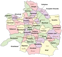 Location of Dargaz County in Razavi Khorasan province (top, pink) | |
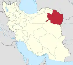 Location of Razavi Khorasan province in Iran | |
| Coordinates: 37°20′25″N 58°58′11″E / 37.34028°N 58.96972°E[1] | |
| Country | Iran |
| Province | Razavi Khorasan |
| Capital | Dargaz |
| Districts | Central, Chapeshlu, Lotfabad, Now Khandan |
| Area | |
• Total | 3,777 km2 (1,458 sq mi) |
| Population (2016)[2] | |
• Total | 72,355 |
| • Density | 19/km2 (50/sq mi) |
| Time zone | UTC+3:30 (IRST) |
| Dargaz County at GEOnet Names Server | |
Dargaz County (Persian: شهرستان درگز) is in Razavi Khorasan province, Iran. Its capital is the city of Dargaz.[3]
Demographics
Population
At the time of the 2006 National Census, the county's population was 73,439 in 19,435 households.[4] The following census in 2011 counted 74,326 people in 21,654 households.[5] The 2016 census measured the population of the county as 72,355 in 22,778 households.[2]
Its prestigious ancient name of Abivard (the Apavartene in the works of the ancient geographers, Ptolemy and Strabo) was changed just a few years ago, believing wrongly that it is a later Arabic name. Apavarta simply meant "rosewater" in Parthian and Old Persian.
Administrative divisions
Dargaz County's population history and administrative structure over three consecutive censuses are shown in the following table.
| Administrative Divisions | 2006[4] | 2011[5] | 2016[2] |
|---|---|---|---|
| Central District | 40,197 | 42,587 | 41,808 |
| Takab RD | 5,892 | 5,533 | 5,046 |
| Dargaz (city) | 34,305 | 37,054 | 36,762 |
| Chapeshlu District | 11,774 | 11,107 | 11,360 |
| Miankuh RD | 4,409 | 3,888 | 4,089 |
| Qarah Bashlu RD | 5,118 | 4,745 | 4,897 |
| Chapeshlu (city) | 2,247 | 2,474 | 2,374 |
| Lotfabad District | 10,374 | 10,013 | 9,432 |
| Dibaj RD | 3,297 | 3,313 | 3,045 |
| Zangelanlu RD | 5,180 | 4,910 | 4,522 |
| Lotfabad (city) | 1,897 | 1,790 | 1,865 |
| Now Khandan District | 11,094 | 10,619 | 9,755 |
| Dorungar RD | 3,296 | 2,944 | 2,753 |
| Shahrestaneh RD | 5,047 | 5,013 | 4,368 |
| Now Khandan (city) | 2,751 | 2,662 | 2,634 |
| Total | 73,439 | 74,326 | 72,355 |
| RD = Rural District | |||
See also
![]() Media related to Dargaz County at Wikimedia Commons
Media related to Dargaz County at Wikimedia Commons
References
- ↑ OpenStreetMap contributors (29 October 2024). "Dargaz County" (Map). OpenStreetMap (in Persian). Retrieved 29 October 2024.
- 1 2 3 Census of the Islamic Republic of Iran, 1395 (2016): Razavi Khorasan Province. amar.org.ir (Report) (in Persian). The Statistical Center of Iran. Archived from the original (Excel) on 2 April 2022. Retrieved 19 December 2022.
- ↑ Habibi, Hassan (c. 2015) [Approved 21 June 1369]. Approval of the organization and chain of citizenship of the elements and units of the divisions of Khorasan province, centered in Mashhad. rc.majlis.ir (Report) (in Persian). Ministry of the Interior, Defense Political Commission of the Government Council. Proposal 3223.1.5.53; Approval Letter 3808-907; Notification 84902/T125K. Archived from the original on 17 November 2015. Retrieved 6 January 2024 – via Islamic Parliament Research Center.
- 1 2 Census of the Islamic Republic of Iran, 1385 (2006): Razavi Khorasan Province. amar.org.ir (Report) (in Persian). The Statistical Center of Iran. Archived from the original (Excel) on 20 September 2011. Retrieved 25 September 2022.
- 1 2 Census of the Islamic Republic of Iran, 1390 (2011): Razavi Khorasan Province. irandataportal.syr.edu (Report) (in Persian). The Statistical Center of Iran. Archived from the original (Excel) on 20 January 2023. Retrieved 19 December 2022 – via Iran Data Portal, Syracuse University.
Razavi Khorasan province | ||
|---|---|---|
| Capital |  | |
| Counties and cities | ||
| Landmarks |
| |
| General |
| |
| Capital | |||||||||||||||||||||||||||||||||||||||
|---|---|---|---|---|---|---|---|---|---|---|---|---|---|---|---|---|---|---|---|---|---|---|---|---|---|---|---|---|---|---|---|---|---|---|---|---|---|---|---|
| Districts |
| ||||||||||||||||||||||||||||||||||||||