Gonabad County
Gonabad County
Persian: شهرستان گناباد | |
|---|---|
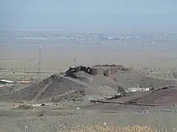 Castle of Yazdegerd III | |
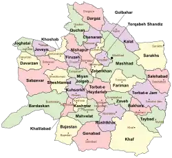 Location of Gonabad County in Razavi Khorasan Province (bottom, pink) | |
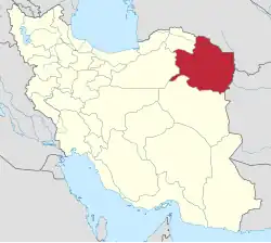 Location of Razavi Khorasan Province in Iran | |
| Coordinates: 34°26′N 58°52′E / 34.433°N 58.867°E[1] | |
| Country | |
| Province | Razavi Khorasan |
| Capital | Gonabad |
| Districts | Central, Kakhk |
| Area | |
• Total | 5,789 km2 (2,235 sq mi) |
| Elevation | 1,105 m (3,625 ft) |
| Population (2016)[2] | |
• Total | 88,753 |
| • Density | 15/km2 (40/sq mi) |
| Time zone | UTC+3:30 (IRST) |
Gonabad County (Persian: شهرستان گناباد) is in Razavi Khorasan Province, Iran. Its capital is the city of Gonabad.[3]
History
After the 2006 National Census, Bajestan District was separated from the county in the establishment of Bajestan County.[4] The village of Rushnavand was elevated to the status of a city in 2020.[5]
Demographics
Population
At the time of the 2006 census, the county's population was 106,158, in 30,357 households.[6] The following census in 2011 counted 80,783 people in 24,292 households.[7] The 2016 census measured the population of the county as 88,753 in 27,607 households.[2]
Administrative divisions
Gonabad County's population history and administrative structure over three consecutive censuses are shown in the following table.
| Administrative Divisions | 2006[6] | 2011[7] | 2016[2] |
|---|---|---|---|
| Central District | 64,849 | 69,773 | 76,427 |
| Howmeh RD | 16,701 | 18,727 | 20,989 |
| Pas Kalut RD | 8,762 | 9,331 | 9,164 |
| Bidokht (city) | 4,823 | 5,348 | 5,501 |
| Gonabad (city) | 34,563 | 36,367 | 40,773 |
| Rushnavand (city)[a] | |||
| Bajestan District[b] | 29,495 | ||
| Bajestan RD | 3,382 | ||
| Jazin RD | 5,294 | ||
| Yunesi RD | 6,334 | ||
| Bajestan (city) | 11,136 | ||
| Yunesi (city) | 3,349 | ||
| Kakhk District | 11,814 | 11,010 | 12,326 |
| Kakhk RD | 3,052 | 2,354 | 2,809 |
| Zibad RD | 4,747 | 4,243 | 4,892 |
| Kakhk (city) | 4,015 | 4,413 | 4,625 |
| Total | 106,158 | 80,783 | 88,753 |
| RD = Rural District | |||
Geography
Gonabad is in a plate area on the north of the Brakoh mountain or Kūh-e Tīr Māhī[8]
Historical places
Gallery
 Zibad Castle
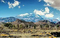 Zibad Mountain
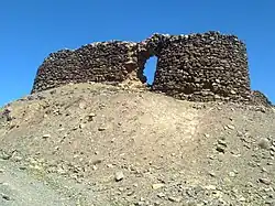 Sassanian Castel
 Ancient water clock used in a qanat of Gonabad 2500 years ago
See also
- Davazdah Rokh
- Zibad
- Kūh-e Tīr Māhī
- Traditional water sources of Persian antiquity
![]() Media related to Gonabad County at Wikimedia Commons
Media related to Gonabad County at Wikimedia Commons
![]() Iran portal
Iran portal
Notes
- ↑ Became a city after the 2016 census[5]
- ↑ Transferred to Bajestan County[4]
References
- ↑ OpenStreetMap contributors (31 October 2024). "Gonabad County" (Map). OpenStreetMap (in Persian). Retrieved 31 October 2024.
- 1 2 3 Census of the Islamic Republic of Iran, 1395 (2016): Razavi Khorasan Province. amar.org.ir (Report) (in Persian). The Statistical Center of Iran. Archived from the original (Excel) on 2 April 2022. Retrieved 19 December 2022.
- ↑ Habibi, Hassan (c. 2015) [Approved 21 June 1369]. Approval of the organization and chain of citizenship of the elements and units of the divisions of Khorasan province, centered in Mashhad. rc.majlis.ir (Report) (in Persian). Ministry of the Interior, Defense Political Commission of the Government Council. Proposal 3223.1.5.53; Approval Letter 3808-907; Notification 84902/T125K. Archived from the original on 17 November 2015. Retrieved 6 January 2024 – via Islamic Parliament Research Center.
- 1 2 Davodi, Parviz (29 October 2019) [Approved 18 September 1386]. Approval letter regarding reforms of national divisions in Razavi Khorasan province, Gonabad County. rc.majlis.ir (Report) (in Persian). Ministry of the Interior, Political-Defense Commission of the Government Board. Proposal 93023/42/4/1; Notification 161409/T38028K. Archived from the original on 20 October 2020. Retrieved 8 November 2023 – via Islamic Parliament Research Center of the Islamic Republic of Iran.
- 1 2 Census of the Islamic Republic of Iran, 1385 (2006): Razavi Khorasan Province. amar.org.ir (Report) (in Persian). The Statistical Center of Iran. Archived from the original (Excel) on 20 September 2011. Retrieved 25 September 2022.
- 1 2 Census of the Islamic Republic of Iran, 1390 (2011): Razavi Khorasan Province. irandataportal.syr.edu (Report) (in Persian). The Statistical Center of Iran. Archived from the original (Excel) on 20 January 2023. Retrieved 19 December 2022 – via Iran Data Portal, Syracuse University.
- ↑ Ajam, Mohammad. Geography and tribes and minorities in Khorasan, research published 1992, University of Imam Sadegh, Tehran
Razavi Khorasan province | ||
|---|---|---|
| Capital | 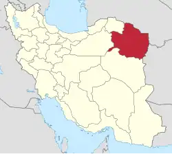 | |
| Counties and cities | ||
| Landmarks |
| |
| General |
| |