Lakki Marwat District
Lakki Marwat
ضلع لکی مروت لکي مروت ولسوالۍ | |
|---|---|
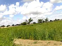 Fields in Sherikhel village | |
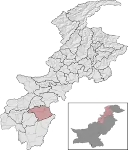 Lakki Marwat District (red) in Khyber Pakhtunkhwa | |
| Country | |
| Province | |
| Division | Bannu |
| Established | 1 July 1992 |
| Headquarters | Lakki Marwat |
| Government | |
| • Type | District Administration |
| • Deputy Commissioner | Iqbal Hussain[1] |
| • District Police Officer | N/A |
| • District Health Officer | N/A |
| Area | |
• Total | 3,296 km2 (1,273 sq mi) |
| Population (2023)[2] | |
• Total | 1,040,856 |
| • Density | 320/km2 (820/sq mi) |
| • Urban | 103,045 (9.90%) |
| • Rural | 927,403 |
| Demographics | |
| • Main language(s) | Pashto • Urdu |
| • HDI | 0.577 |
| Literacy | |
| • Literacy rate |
|
| Time zone | UTC+5 (PST) |
| Number of Tehsils | 3 |
| Website | lakkimarwat |
Lakki Marwat (Pashto: لکي مروت ولسوالۍ, Urdu: ضلع لکی مروت) is a district in the Bannu Division of the Khyber Pakhtunkhwa province of Pakistan. It was created as an administrative district on 1 July 1992, prior to which it was a tehsil of Bannu District.
Geography
The district is located in a southern part of Khyber Paktunkhwa. It borders Karak and Bannu districts to the north, Tank district to the west, Dera Ismail Khan district to the south, and Mianwali district of Punjab to the east.
The district is a combination of mountains and sandy plains. The mountainous areas are along the boundaries of the district especially in the east, southeast, southwest and northwest. In the southeast, the Marwat range separates Lakki Marwat from the Dera Ismail Khan district while in the east the Karak Niazi range separates it from the Mianwali d of district of Punjab. It is surrounded by Baittani range on the west and southwest, which separates it from Tank District and South Waziristan districts. The Marwat range culminates and Baittani ranges starts near Sheikh Badin. The general elevation of these hills ranges from 500 to 1000 meters above the sea level. The land beyond these hills gradually slopes to the central part, which looks like a basin. A large number of streams flow from the surrounding hills. The Kurram river flows through the district from northwest to the southeast and joins the Indus River south of Isakhel town. One of its important tributary is Gambila river, also known as the Tochi. The major part of this basin is an alluvial plain. A northern portion of this plain is situated chiefly in the Kurram Gambila Doab and irrigated by the Kurram river. It is a flat sandy area. The southern part is made up of undulating dunes of sand, furrowed at regular intervals by deep torrent beds which carry the drainage of the Marwat and Baittani ranges to the Gambila. It is good for cultivation, water table is quite deep below the soil surface. In the western portion of the district, the soil is fairly stiff clay covered by a layer of stones at the foot of the hills. The whole district is intersected by numerous hill torrents and deep ravines. The general elevation of the plain area is about 200 to 300 meters above sea level.
Climate
The region has all the characteristics of a desert due to its sand dunes, scorching heat and dry weather. Summers are hot, while winters are moderately cool. The summer season begins from early May and continues till late September. June and July are the hottest months with a maximum temperature range of 42 to 45 degree Celsius and a minimum temperature range of about 29 to 35 degree Celsius. Periodic sand storms rage through the area during May and June due to the prevalent low humidity. The hot wind, locally known as Lu blows across the district in these months. The cool wave starts in October. Late November, December, January and February and early March are the winter months. Though the daytime temperature in winter is not that low, however there is always a sharp decrease in nights. The mean maximum and minimum temperatures during this period are 20 and 4 degree Celsius respectively. Rainfall is rare and sporadic and generally rains occur in July and August.
Administration
Lakki Marwat district is subdivided into five Tehsils:
- Lakki Marwat Tehsil[4]
- Sari Naurang Tehsil[4]
- Ghazni Khel Tehsil
- Bettani Tehsil (Urdu: تحصیل بیٹنی)(Pashto: بېټني تحصیل)
- Formerly Frontier Region Lakki Marwat (Urdu: سرحدی علاقہ لکی مروت)(Pashto: لکي مروت سرحدي سیمه)
The district has three municipal committees.[5] There are 157 mauzas (the smallest revenue unit).[5]
Provincial Assembly
| Member of Provincial Assembly | Party Affiliation | Constituency | Year | |
|---|---|---|---|---|
| Munawar Khan | Muttahida Majlis-e-Amal | Lakki Marwat-I | 2018 | |
| Hisham Inamullah Khan | Pakistan Tehreek-e-Insaf | Lakki Marwat-II | 2018 | |
| Anwar Hayat Khan | Muttahida Majlis-e-Amal | Lakki Marwat-III | 2018 | |
Demographics
| Year | Pop. | ±% p.a. |
|---|---|---|
| 1961 | ... | — |
| 1972 | ... | — |
| 1981 | ... | — |
| 1998 | ... | — |
| 2017 | 902,541 | — |
| 2023 | 1,040,856 | +2.40% |
| Sources:[6] | ||
As of the 2023 census, Lakki Marwat district has 131,800 households and a population of 1,040,856. The district has a sex ratio of 102.61 males to 100 females and a literacy rate of 48.47%: 67.36% for males and 28.95% for females. 344,296 (33.22% of the surveyed population) are under 10 years of age. 103,089 (9.90%) live in urban areas.[2] Pashto was the predominant language, spoken by 99.66% of the population.[7]
Religion
| 1941[8][a] | 2017[4] | 2023[9] | ||||
|---|---|---|---|---|---|---|
| Religion | Pop. | % | Pop. | % | Pop. | % |
| Islam |
100,551 | 92.82% | 901,932 | 99.98% | 1,034,204 | 99.80% |
| Hinduism |
6,954 | 6.42% | 16 | ~0% | 24 | ~0% |
| Sikhism |
827 | 0.76% | — | — | 12 | ~0% |
| Christianity |
0 | 0.00% | 43 | ~0% | 2,040 | 0.20% |
| Others | 0 | 0.00% | 147 | 0.02% | 20 | ~0% |
| Total Population | 108,332 | 100% | 902,138 | 100% | 1,036,300[b] | 100% |
Transport
Lakki Marwat was connected with Mari Indus through a narrow gauge railway line during the Raj. The city, a tehsil of Bannu then, was a railway junction. One line went to Bannu, its district, and the other to Tank. The extent of railways network has ever since defined the limits of the settled area bordering the tribal area to its west. The railway track has since been uprooted and the area now is connected through a network of roads. A detailed account of the rise and fall of this particular railway junction was published in the Daily Dawn .
Notable people
- Abdul Shakoor, former Minister of Religious Affairs
- Sant Singh Maskeen, influential Sikh scholar and theologian
Neighboring areas
- Mianwali District
- Tank District
- Waziristan
- Karak
- Dera Ismail Khan
- Bannu
See also
- Marwat
- Districts of Pakistan
References
- ↑ "Widening of key Lakki road okayed". Dawn newspaper. 15 January 2022. Retrieved 3 March 2024.
- 1 2 "7th Population and Housing Census - Detailed Results: Table 1" (PDF). www.pbscensus.gov.pk. Pakistan Bureau of Statistics.
- ↑ "Literacy rate, enrolments, and out-of-school population by sex and rural/urban, CENSUS-2023, KPK" (PDF).
- 1 2 3 "Pakistan Census 2017 District-Wise Tables: Lakki Marwat". Pakistan Bureau of Statistics.
- 1 2 1998 District Census Report of Lakki Marwat, Population Census Organisation, Statistics Division, Government of Pakistan, Islamabad, 2000 Pg 23
- ↑ "Population by administrative units 1951-1998" (PDF). Pakistan Bureau of Statistics.
- ↑ "7th Population and Housing Census - Detailed Results: Table 11" (PDF). Pakistan Bureau of Statistics.
- ↑ "CENSUS OF INDIA, 1941 VOLUME X NORTH-WEST FRONTIER PROVINCE". Retrieved 14 October 2021.
- ↑ "7th Population and Housing Census - Detailed Results: Table 9" (PDF). Pakistan Bureau of Statistics.
- ↑ Lakki Marwat tehsil of erstwhile Bannu district, which roughly corresponds to the present district excluding the former Frontier Region Lakki Marwat. District and tehsil borders have shifted since 1941.
- ↑ Different from official population figure since it excludes sensitive areas where religion was not asked
External links
- Early history of Marwats - ARCHIVED
- Herbert Edwardes's description of Marwats .Hadi(1996).(1848–49) - ARCHIVED
- Marwat uprising against the Sikhs (1847) - ARCHIVED
- District Government Lakki Marwat
- The Rise and Fall of a Railway Junction
Provincial capital: Peshawar | ||
| Bannu |  | |
| Dera Ismail Khan | ||
| Hazara |
| |
| Kohat | ||
| Malakand | ||
| Mardan | ||
| Peshawar | ||
| Former |
| |
Administrative subdivisions of Lakki Marwat District | ||
|---|---|---|
| Capital |
| |
| Union councils |
| |