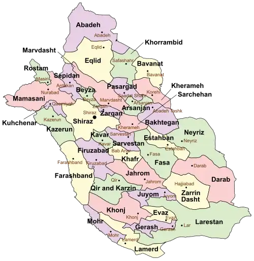
Zarrin Dasht County
Zarrin Dasht County
Persian: شهرستان زریندشت | |
|---|---|
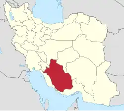
 Location of Zarrin Dasht County in Fars province (bottom right, yellow) | |
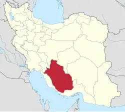 Location of Fars province in Iran | |
| Coordinates: 28°20′N 54°28′E / 28.333°N 54.467°E[1] | |
| Country | Iran |
| Province | Fars |
| Capital | Hajjiabad |
| Districts | Central, Izadkhast |
| Population (2016)[2] | |
• Total | 73,199 |
| Time zone | UTC+3:30 (IRST) |
| Zarrin Dasht County can be found at GEOnet Names Server, at this link, by opening the Advanced Search box, entering "9206487" in the "Unique Feature Id" form, and clicking on "Search Database". | |
Zarrin Dasht County (Persian: شهرستان زریندشت) is in Fars province, Iran. Its capital is the city of Hajjiabad.[3]
Demographics
Population
At the time of the 2006 National Census, the county's population was 60,444 in 13,378 households.[4] The following census in 2011 counted 69,438 people in 17,402 households.[5] The 2016 census measured the population of the county as 73,199 in 20,328 households.[2]
Administrative divisions
Zarrin Dasht County's population history and administrative structure over three consecutive censuses are shown in the following table.
| Administrative Divisions | 2006[4] | 2011[5] | 2016[2] |
|---|---|---|---|
| Central District | 47,323 | 50,990 | 54,027 |
| Dobiran RD[a] | 2,160 | 148 | 691 |
| Khosuyeh RD | 10,641 | 10,482 | 10,483 |
| Zirab RD[b] | 6,279 | 7,177 | 7,369 |
| Dobiran (city) | 9,897 | 12,682 | 13,809 |
| Hajjiabad (city) | 18,346 | 20,501 | 21,675 |
| Izadkhast District | 13,121 | 17,686 | 18,924 |
| Izadkhast-e Gharbi RD[c] | 2,946 | 5,836 | 4,864 |
| Izadkhast-e Sharqi RD | 3,014 | 3,750 | 5,133 |
| Shahr-e Pir (city) | 7,161 | 8,100 | 8,927 |
| Total | 60,444 | 69,438 | 73,199 |
| RD = Rural District | |||
See also
![]() Media related to Zarrin Dasht County at Wikimedia Commons
Media related to Zarrin Dasht County at Wikimedia Commons
Notes
- ↑ Formerly Dasht-e Khak Rural District[6]
- ↑ Formerly Hajjiabad Rural District[6]
- ↑ Formerly Izadkhast Rural District[3]
References
- ↑ OpenStreetMap contributors (10 October 2024). "Zarrin Dasht County" (Map). OpenStreetMap (in Persian). Retrieved 10 October 2024.
- 1 2 3 Census of the Islamic Republic of Iran, 1395 (2016): Fars Province. amar.org.ir (Report) (in Persian). The Statistical Center of Iran. Archived from the original (Excel) on 6 April 2022. Retrieved 19 December 2022.
- 1 2 Habibi, Hassan (13 September 2013) [Approved 27 December 1379]. Creating changes within the boundaries of the national divisions of Darab County, Fars province. rc.majlis.ir (Report) (in Persian). Ministry of the Interior, Board of Ministers. Notification 59562/23247H. Archived from the original on 4 December 2013. Retrieved 7 December 2023 – via Research Center of the System of Laws of the Islamic Council of the Farabi Library of Mobile Users.
- 1 2 Census of the Islamic Republic of Iran, 1385 (2006): Fars Province. amar.org.ir (Report) (in Persian). The Statistical Center of Iran. Archived from the original (Excel) on 20 September 2011. Retrieved 25 September 2022.
- 1 2 Census of the Islamic Republic of Iran, 1390 (2011): Fars Province. irandataportal.syr.edu (Report) (in Persian). The Statistical Center of Iran. Archived from the original (Excel) on 16 January 2023. Retrieved 19 December 2022 – via Iran Data Portal, Syracuse University.
- 1 2 Habibi, Hassan (c. 2024) [Approved 25 June 1371]. Approval of reforms in the rural districts of Fars province. lamtakam.com (Report) (in Persian). Ministry of the Interior, Defense Political Commission of the Government Council. Proposal 1.4.42.4528; Notification 23416/T31K. Archived from the original on 17 April 2024. Retrieved 17 April 2024 – via Lam ta Kam.
Fars province, Iran | ||
|---|---|---|
| Capital |
|  |
| Counties and cities | ||
| Landmarks |
| |
| Populated places |
| |
| Capital |
| ||||||||||||||||||||||
|---|---|---|---|---|---|---|---|---|---|---|---|---|---|---|---|---|---|---|---|---|---|---|---|
| Districts |
| ||||||||||||||||||||||
This article is issued from Wikipedia. The text is licensed under Creative Commons - Attribution - Sharealike. Additional terms may apply for the media files.