Bavanat County
Bavanat County
Persian: شهرستان بوانات | |
|---|---|
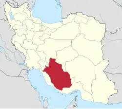
 Location of Bavanat County in Fars province (top right, yellow) | |
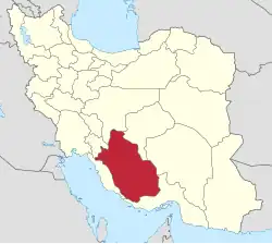
 Location of Fars province in Iran | |
| Coordinates: 30°26′N 53°31′E / 30.433°N 53.517°E[1] | |
| Country | Iran |
| Province | Fars |
| Capital | Bavanat |
| Districts | Central, Mazayjan |
| Population (2016)[2] | |
• Total | 50,418 |
| Time zone | UTC+3:30 (IRST) |
| Bavanat County can be found at GEOnet Names Server, at this link, by opening the Advanced Search box, entering "9206469" in the "Unique Feature Id" form, and clicking on "Search Database". | |
Bavanat County (Persian: شهرستان بوانات) is in Fars province, Iran. Its capital is the city of Bavanat.[3][a]
History
After the 2006 National Census, Mazayjan and Sarvestan Rural Districts were separated from the Central District in the formation of Mazayjan District.[5] In addition, the village of Hesami was elevated to the status of a city.[6] After the 2011 census, the village of Mazayjan rose to city status as well.[7]
In 2018, Sarchehan District was separated from the county in the establishment of Sarchehan County.[8]
Demographics
Population
At the time of the 2006 census, the county's population was 44,069 in 11,341 households.[9] The following census in 2011 counted 48,416 people in 13,636 households.[10] The 2016 census measured the population of the county as 50,418 in 15,874 households.[2]
Administrative divisions
Bavanat County's population history and administrative structure over three consecutive censuses are shown in the following table.
| Administrative Divisions | 2006[9] | 2011[10] | 2016[2] |
|---|---|---|---|
| Central District | 25,136 | 16,442 | 16,698 |
| Baghestan RD | 4,200 | 3,913 | 4,410 |
| Mazayjan RD | 5,440 | ||
| Sarvestan RD | 3,804 | ||
| Simakan RD | 2,047 | 1,859 | 2,512 |
| Bavanat (city)[a] | 9,645 | 10,670 | 9,776 |
| Mazayjan District | 8,974 | 10,591 | |
| Mazayjan RD | 5,251 | 2,985 | |
| Sarvestan RD | 3,723 | 4,039 | |
| Mazayjan (city) | 3,567 | ||
| Sarchehan District[b] | 18,933 | 22,492 | 23,129 |
| Bagh Safa RD | 4,432 | 5,203 | 5,004 |
| Sarchehan RD | 5,002 | 2,925 | 3,703 |
| Tujerdi RD | 6,341 | 7,626 | 7,337 |
| Hesami (city) | 2,826 | 3,131 | |
| Korehi (city) | 3,158 | 3,912 | 3,954 |
| Total | 44,069 | 48,416 | 50,418 |
| RD = Rural District | |||
See also
![]() Media related to Bavanat County at Wikimedia Commons
Media related to Bavanat County at Wikimedia Commons
Notes
References
- ↑ OpenStreetMap contributors (30 September 2024). "Bavanat County" (Map). OpenStreetMap (in Persian). Retrieved 30 September 2024.
- 1 2 3 Census of the Islamic Republic of Iran, 1395 (2016): Fars Province. amar.org.ir (Report) (in Persian). The Statistical Center of Iran. Archived from the original (Excel) on 6 April 2022. Retrieved 19 December 2022.
- ↑ Habibi, Hassan (c. 2022) [Approved 21 July 1374]. Divisional reforms in Fars province. rc.majlis.ir (Report) (in Persian). Ministry of the Interior, Political and Defense Commission of the Government Board. Proposal 1.42.3703; Notification 9116/T14125K. Archived from the original on 21 April 2022. Retrieved 30 September 2024 – via Martyrdom of Imam Ali (AS) Research Center of the Islamic Council.
- ↑ Habibi, Hassan (c. 2022) [Approved 16 March 1380]. Approval letter regarding changing the name of the city of Surian to the city of Bavanat. qavanin.ir (Report) (in Persian). Ministry of the Interior, Council of Ministers. Proposal 70569/42/1/4/1. Archived from the original on 18 July 2022. Retrieved 14 September 2023 – via Laws and Regulations Portal of the Islamic Republic of Iran.
- ↑ "Four cities and two new counties will be created; with 20 changes in the map of national divisions". dolat.ir (in Persian). Ministry of the Interior, Political and Defense Commission. 19 June 2010. Archived from the original on 26 March 2017. Retrieved 9 November 2023 – via Secretariat of the Government Information Council.
- ↑ Rahimi, Mohammadreza (4 January 2011). "Hesami city was added to the map of national divisions". dolat.ir (in Persian). Ministry of the Interior, Political and Defense Commission. Archived from the original on 15 March 2017. Retrieved 9 November 2023 – via Secretariat of the Government Information Council.
- ↑ Rahimi, Mohammadreza (13 January 2013). "Four new cities were added to the map of national divisions; with some changes in the geography map of two provinces". dolat.ir (in Persian). Ministry of the Interior, Political and Defense Commission. Archived from the original on 31 May 2017. Retrieved 9 November 2023 – via Secretariat of the Government Information Council.
- 1 2 Jahangiri, Ishaq (c. 2023) [Approved 10 July 2018]. Letter of approval regarding the national divisions of Bavanat County, Fars province. qavanin.ir (Report) (in Persian). Ministry of the Interior, Board of Ministers. Proposal 208742. Archived from the original on 15 September 2023. Retrieved 15 September 2023 – via Laws and Regulations Portal of the Islamic Republic of Iran.
- 1 2 Census of the Islamic Republic of Iran, 1385 (2006): Fars Province. amar.org.ir (Report) (in Persian). The Statistical Center of Iran. Archived from the original (Excel) on 20 September 2011. Retrieved 25 September 2022.
- 1 2 Census of the Islamic Republic of Iran, 1390 (2011): Fars Province. irandataportal.syr.edu (Report) (in Persian). The Statistical Center of Iran. Archived from the original (Excel) on 16 January 2023. Retrieved 19 December 2022 – via Iran Data Portal, Syracuse University.
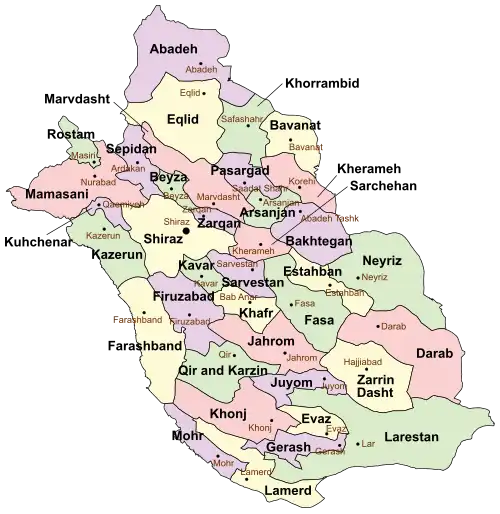
Fars province, Iran | ||
|---|---|---|
| Capital |
|  |
| Counties and cities | ||
| Landmarks |
| |
| Populated places |
| |
| Capital |
| ||||||||||||||||||||||||||
|---|---|---|---|---|---|---|---|---|---|---|---|---|---|---|---|---|---|---|---|---|---|---|---|---|---|---|---|
| Districts |
| ||||||||||||||||||||||||||