Zarand County
Zarand County
Persian: شهرستان زرند | |
|---|---|
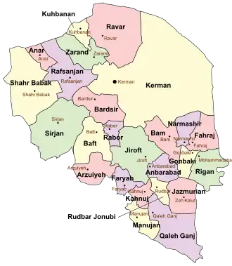 Location of Zarand County in Kerman province (top, green) | |
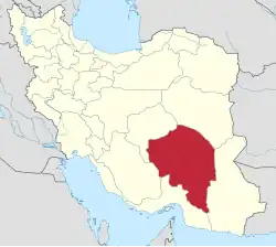 Location of Kerman province in Iran | |
| Coordinates: 30°57′N 56°21′E / 30.950°N 56.350°E[1] | |
| Country | |
| Province | Kerman |
| Capital | Zarand |
| Districts | Central, Yazdanabad |
| Population (2016)[2] | |
• Total | 138,133 |
| Time zone | UTC+3:30 (IRST) |
| Zarand County can be found at GEOnet Names Server, at this link, by opening the Advanced Search box, entering "9206679" in the "Unique Feature Id" form, and clicking on "Search Database". | |
Zarand County (Persian: شهرستان زرند) is in Kerman province, Iran. Its capital is the city of Zarand.[3]
History
After the 2006 National Census, Shaab Jereh Rural District was separated from Kuhbanan County to join Zarand County.[4] After the 2016 census, the village of Siriz was elevated to the status of a city.[5]
Demographics
Population
At the time of the 2006 census, the county's population was 119,144 in 28,746 households.[6] The following census in 2011 counted 129,104 people in 35,388 households,[7] The 2016 census measured the population of the county as 138,133 in 39,451 households.[2]
Administrative divisions
Zarand County's population history and administrative structure over three consecutive censuses are shown in the following table.
| Administrative Divisions | 2006[6] | 2011[7] | 2016[2] |
|---|---|---|---|
| Central District | 103,208 | 110,199 | 121,206 |
| Dasht-e Khak RD | 4,060 | 4,333 | 4,199 |
| Eslamabad RD | 830 | 837 | 1,136 |
| Hotkan RD | 1,247 | 679 | 898 |
| Jorjafak RD | 2,382 | 1,973 | 2,393 |
| Khanuk RD | 900 | 944 | 1,136 |
| Mohammadabad RD | 13,252 | 16,399 | 21,440 |
| Sarbanan RD | 2,817 | 2,263 | 2,706 |
| Vahdat RD | 15,033 | 18,078 | 19,720 |
| Khanuk (city) | 3,582 | 2,153 | 2,628 |
| Reyhan Shahr (city)[a] | 4,360 | 4,791 | 4,580 |
| Zarand (city) | 54,745 | 57,749 | 60,370 |
| Yazdanabad District | 15,936 | 18,905 | 16,927 |
| Shaab Jereh RD[b] | 1,790 | 2,383 | |
| Siriz RD | 4,792 | 5,048 | 4,841 |
| Yazdanabad RD | 6,107 | 6,625 | 4,096 |
| Siriz (city)[c] | |||
| Yazdan Shahr (city)[d] | 5,037 | 5,442 | 5,607 |
| Total | 119,144 | 129,104 | 138,133 |
| RD = Rural District | |||
See also
![]() Media related to Zarand County at Wikimedia Commons
Media related to Zarand County at Wikimedia Commons
![]() Iran portal
Iran portal
Notes
References
- ↑ OpenStreetMap contributors (10 December 2024). "Zarand County" (Map). OpenStreetMap (in Persian). Retrieved 10 December 2024.
- 1 2 3 Census of the Islamic Republic of Iran, 1395 (2016): Kerman Province. amar.org.ir (Report) (in Persian). The Statistical Center of Iran. Archived from the original (Excel) on 20 October 2020. Retrieved 19 December 2022.
- ↑ Habibi, Hassan (c. 2024) [Approved 21 June 1369]. Approval of the organization and chain of citizenship of the elements and units of the national divisions of Kerman province, centered in the city of Kerman. lamtakam.com (Report) (in Persian). Ministry of the Interior, Defense Political Commission of the Government Council. Proposal 3233.1.5.53; Letter 907-93808; Notification 82812/T139K. Archived from the original on 30 January 2024. Retrieved 30 January 2024 – via Lam ta Kam.
- 1 2 Rahimi, Mohammadreza (10 December 2014) [Approved 28 January 1390]. Approval letter regarding the annexation of Shaab Jereh Rural District centered on Shaab Jereh village, from Toghrol ol Jerd District of Kuhbanan County in Kerman province to Yazdanabad District of Zarand County. rc.majlis.ir (Report) (in Persian). Ministry of the Interior, Political and Defense Commission. Proposal 38527/42/1/4/1; Letter 158802/T38854H; Notification 35763/T40138K. Archived from the original on 30 November 2014. Retrieved 21 November 2023 – via Islamic Parliament Research Center.
- 1 2 Jahangiri, Ishaq (7 April 2019) [Approved 13 December 1397]. Approval regarding the conversion of the villages of Siriz, Deh-e Khvajeh, Fathabad, Deh-e Bala, Muruiyeh and Deh-e Now into cities. sdil.ac.ir (Report) (in Persian). Ministry of the Interior, Cabinet of Ministers. Proposal 49707; Notification 168723/T55514H. Archived from the original on 24 March 2023. Retrieved 28 January 2025 – via Shahr Danesh Legal Research Institute.
- 1 2 Census of the Islamic Republic of Iran, 1385 (2006): Kerman Province. amar.org.ir (Report) (in Persian). The Statistical Center of Iran. Archived from the original (Excel) on 20 September 2011. Retrieved 25 September 2022.
- 1 2 Census of the Islamic Republic of Iran, 1390 (2011): Kerman Province. irandataportal.syr.edu (Report) (in Persian). The Statistical Center of Iran. Archived from the original (Excel) on 29 March 2023. Retrieved 19 December 2022 – via Iran Data Portal, Syracuse University.
- 1 2 Aref, Mohammad Reza (c. 2024) [Approved 18 August 1383]. Divisional reforms in Kerman province. lamtakam.com (Report) (in Persian). Ministry of the Interior, Political-Defense Commission of the Government Board. Proposal 1.4.42.46506; Resolution 58538/T26118H; Notification 13144/T29173K. Archived from the original on 11 December 2024. Retrieved 11 December 2024 – via Lam ta Kam.
Kerman province, Iran | ||
|---|---|---|
| Capital |
|  |
| Counties and cities | ||
| Sights |
| |
| Places |
| |
| Capital |
| ||||||||||||||||
|---|---|---|---|---|---|---|---|---|---|---|---|---|---|---|---|---|---|
| Districts |
| ||||||||||||||||