Wutai, Pingtung
22°45′N 120°44′E / 22.75°N 120.73°E
Wutai Township 霧臺鄉 | |
|---|---|
 Wutai Village | |
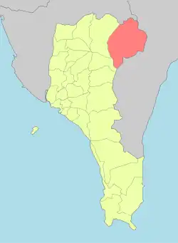 Wutai Township in Pingtung County | |
| Location | Pingtung County, Taiwan |
| Area | |
• Total | 279 km2 (108 sq mi) |
| Population (February 2024) | |
• Total | 3,266 |
| • Density | 12/km2 (30/sq mi) |
Wutai Township (Chinese: 霧臺鄉; pinyin: Wùtái Xiāng; Rukai language: Vedai) is a mountain indigenous township in Pingtung County, Taiwan. It has a population total of 3,266 and an area of 278.80 square kilometres (107.65 sq mi).
History
During the Japanese era, Wutai was grouped with modern-day Sandimen Township and Majia Township as "Aboriginal Areas" (Japanese: 蕃地), which was governed under Heitō District, Takao Prefecture.
Demographics
The township is mainly inhabited by the Rukai people.[1]
Administrative divisions
The township comprises six villages: Ali, Dawu, Haocha, Jiamu, Jilou and Wutai.
Tourist attractions
- Guchuan Bridge
- Kucapungane, an ancient Rukai village with houses built of shale slabs[2]
References
- ↑ "The humanity of Indigenous peoples". Pingtung County Government.
- ↑ Chung, Jake (17 October 2015). "Rukai village included on list of world cultural sites". Taipei Times. p. 1.
External links
Wikimedia Commons has media related to Wutai Township, Pingtung County.
Cities and townships of Pingtung County | ||
|---|---|---|
County seat: Pingtung City | ||
| Cities |
|  |
| Urban townships | ||
| Rural townships | ||
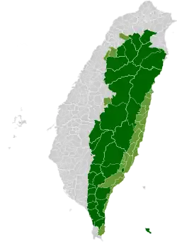
| Mountain indigenous townships | ||
| Highland indigenous Townships and Districts |
|  | ||||||||||||||||||||||||
|---|---|---|---|---|---|---|---|---|---|---|---|---|---|---|---|---|---|---|---|---|---|---|---|---|---|---|
| Plains indigenous Townships and County-Administered Cities |
| |||||||||||||||||||||||||
Note: On the map, "Mountain Indigenous Areas" are in dark green and "Plains Indigenous Areas" are in light green. | ||||||||||||||||||||||||||
This article is issued from Wikipedia. The text is licensed under Creative Commons - Attribution - Sharealike. Additional terms may apply for the media files.