Selangau District
Selangau District | |
|---|---|
 Districts of Sarawak | |
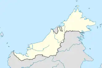 Selangau District Location of Selangau in Malaysian Borneo | |
| Coordinates: 2°29′57″N 112°19′19″E / 2.49917°N 112.32194°E | |
| District Office location | Selangau |
| Local area government | Sibu Rural District Council |
| Area | |
• Total | 3,795 km2 (1,465 sq mi) |
| Population (2024[1]) | |
• Total | 49,075 |
| • Density | 13/km2 (33/sq mi) |
| District Officer | Yalin Anak Asan[2] |
| Postcode | 96000 |
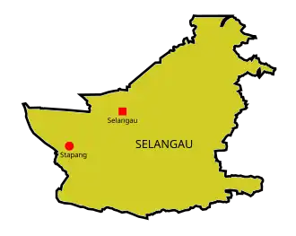
Map of Selangau District
The Selangau District is a district in Sarawak, Malaysia.[3]
History
Selangau was declared a district on 1 March 2002.[4]
Demographics
Ethnicity
| Ethnicity | 2024 | |
|---|---|---|
| Pop. | % | |
| Malays | 2850 | 5.81% |
| Iban | 39854 | 81.21% |
| Bidayuh | 108 | 0.22% |
| Melanau | 2176 | 4.43% |
| Other Bumiputeras | 32 | 0.07% |
| Chinese | 3915 | 7.98% |
| Indians | 0 | 0% |
| Others | 0 | 0% |
| Malaysian total | 48935 | 99.71% |
| Non-Malaysian | 140 | 0.29% |
| Total | 49075 | 100.00% |
| Year | Pop. | ±% |
|---|---|---|
| 1975 | 6,130 | — |
| 1980 | 8,512 | +38.9% |
| 1985 | 10,834 | +27.3% |
| 1990 | 15,173 | +40.0% |
| 1995 | 19,532 | +28.7% |
| 2004 | 25,410 | +30.1% |
| 2010 | 31,286 | +23.1% |
| 2015 | 38,564 | +23.3% |
| 2024 | 49,075 | +27.3% |
| Source: [5] | ||
References
- 1 2 "Population Demography by Districts". Jabatan Perangkaan Malaysia. Retrieved 29 March 2025.
- ↑ "Pejabat Daerah Selangau" (in Malay). Pentadbiran Bahagian Sibu. Retrieved 27 March 2025.
- ↑ "Sarawak Population". The Official Portal of the Sarawak Government. Retrieved 7 January 2018.
- ↑ Florence Genta (15 April 2018). "More developments in store for Selangau". New Sarawak Tribune. Retrieved 4 July 2018.
- ↑ "TABURAN PENDUDUK MENGIKUT PBT & MUKIM 2010". Department of Statistics, Malaysia. Retrieved 15 December 2017.
State of Sarawak | |||||||||||
|---|---|---|---|---|---|---|---|---|---|---|---|
Capital: Kuching | |||||||||||
| History |
| ||||||||||
| Topics |
| ||||||||||
| Society |
| ||||||||||
| Administrative divisions |
| ||||||||||
| |||||||||||
This article is issued from Wikipedia. The text is licensed under Creative Commons - Attribution - Sharealike. Additional terms may apply for the media files.