Kabong District
Kabong | |
|---|---|
| Country | |
| State | |
| Area | |
• Total | 799 km2 (308 sq mi) |
| Population (2024) | |
• Total | 24,381 |
| • Density | 31/km2 (79/sq mi) |
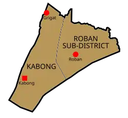
Map of Kabong District
Kabong is a district, in Betong Division, Sarawak, Malaysia.[1][2]
Demographics
Ethnicity
| Ethnicity | 2024 | |
|---|---|---|
| Pop. | % | |
| Malays | 16804 | 68.92% |
| Iban | 5820 | 23.87% |
| Bidayuh | 35 | 0.14% |
| Melanau | 516 | 2.12% |
| Other Bumiputeras | 43 | 0.18% |
| Chinese | 872 | 3.58% |
| Indians | 0 | 0% |
| Others | 0 | 0% |
| Malaysian total | 24090 | 98.81% |
| Non-Malaysian | 291 | 1.19% |
| Total | 24381 | 100.00% |
| Year | Pop. | ±% |
|---|---|---|
| 1990 | 3,876 | — |
| 1995 | 5,984 | +54.4% |
| 2004 | 7,890 | +31.9% |
| 2010 | 12,863 | +63.0% |
| 2015 | 18,192 | +41.4% |
| 2024 | 24,381 | +34.0% |
| Source: [3] | ||
Religions
Total population of every areas in Kabong, Sarawak. These population are exactly based on their ethnics in Sarawak.
Kabong is the only district that predominantly Sarawak Malay community, especially in Kabong Town and Gerigat. Only Roban area is mostly are community from Iban ethnic.
Transport
Local Bus
| Route No. | Operating Route | Operator | Remark |
|---|---|---|---|
| 24 | Sarikei-Kabong | Borneo Bus | |
References
- ↑ "Malaysia Districts". Statoids.com. Retrieved 3 November 2010.
- ↑ "Malaysia: Administrative Division". City Population. Retrieved 30 January 2019.
- ↑ "TABURAN PENDUDUK MENGIKUT PBT & MUKIM 2010". Department of Statistics, Malaysia. Retrieved 15 December 2017.
State of Sarawak | |||||||||||
|---|---|---|---|---|---|---|---|---|---|---|---|
Capital: Kuching | |||||||||||
| History |
| ||||||||||
| Topics |
| ||||||||||
| Society |
| ||||||||||
| Administrative divisions |
| ||||||||||
| |||||||||||
1°49′42.0″N 111°08′01.2″E / 1.828333°N 111.133667°E
This article is issued from Wikipedia. The text is licensed under Creative Commons - Attribution - Sharealike. Additional terms may apply for the media files.