Polog Statistical Region
Polog Statistical Region
Полошки Регион Rajoni i Pollogut | |
|---|---|
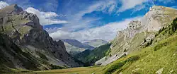 Šar Mountains | |
|
Coat of arms | |
 | |
| Area | |
• Total | 2,479 km2 (957 sq mi) |
| Population (2021)[1] | |
• Total | 251,552 |
| • Density | 100/km2 (260/sq mi) |
| HDI (2017) | 0.767[2] high · 6th of 8 |
| Website | rdcpolog |
The Polog Statistical Region (Macedonian: Полошки Регион, romanized: Pološki Region; Albanian: Rajoni i Pollogut) is one of eight statistical regions of the Republic of North Macedonia. Polog, located in the northwestern part of the country, borders Albania and Kosovo. Internally, it borders the Southwestern and Skopje statistical regions.
Municipalities

The municipalities of the Polog statistical region
Polog is divided into 9 municipalities:
 Bogovinje
 Brvenica
 Gostivar
 Jegunovce
 Mavrovo and Rostuša
 Tearce
 Tetovo
 Vrapčište
 Želino
Demographics
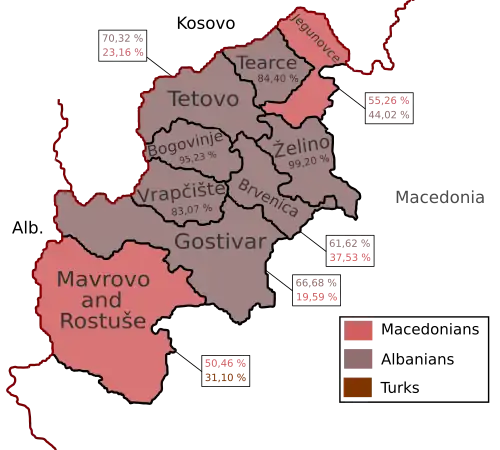
Map of the majority ethnic groups in the region.
Population
The current population of the Polog statistical region is 304,125 citizens, according to the last population census in 2002.
| Census Year | Population | Change |
|---|---|---|
| 1994 | 282,432 | N/A |
| 2002 | 304,125 | +8.24% |
| 2021 | 251,552 | -17.4% |
Ethnicities
The largest ethnic group in the region are the Albanians (68.91%) followed by the Macedonians (17.21%), Turks (6.04%), Roma (1.7%).
| 2002 | 2021 | |||
| Number | % | Number | % | |
| TOTAL | 304,125 | 100 | 251,552 | 100 |
| Albanians | 222,679 | 73.22 | 173,344 | 68.91 |
| Macedonians | 56,079 | 18.44 | 43,285 | 17.21 |
| Turks | 17,394 | 5.72 | 15,182 | 6.04 |
| Roma | 4,717 | 1.55 | 4,264 | 1.7 |
| Serbs | 977 | 0.32 | 494 | 0.2 |
| Bosniaks | 251 | 0.08 | 271 | 0.1 |
| Vlachs | 30 | 0.01 | 31 | 0.01 |
| Others / Undeclared / Unknown | 1,998 | 0.66 | 2,021 | 0.8 |
| Persons for whom data are taken from the administrative sources | 12,660 | 5.03 | ||
See also
- Polog
References
- ↑ "North Macedonia: Statistical Regions & Major Settlements - Population Statistics, Maps, Charts, Weather and Web Information".
- ↑ "Sub-national HDI - Area Database - Global Data Lab". hdi.globaldatalab.org. Retrieved 2018-09-13.
External links
 Media related to Polog Statistical Region at Wikimedia Commons
This article is issued from Wikipedia. The text is licensed under Creative Commons - Attribution - Sharealike. Additional terms may apply for the media files.