Pelagonia Statistical Region
Pelagonia Statistical Region
Пелагониски Регион | |
|---|---|
 Baba Mountain | |
|
Flag | |
 | |
| Country | |
| Area | |
• Total | 4,719 km2 (1,822 sq mi) |
| Population (2021)[1] | |
• Total | 210,431 |
| • Density | 45/km2 (120/sq mi) |
| HDI (2019) | 0.772[2] high · 2nd of 8 |
| Website | pelagonijaregion |
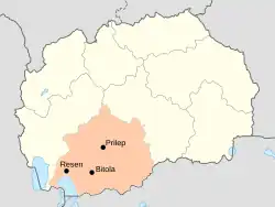
The Pelagonia Statistical Region (Macedonian: Пелагониски Регион, romanized: Pelagoniski Region) is one of eight statistical regions of North Macedonia. It is located in southwestern part of the country along the eponymous plain, bordering Greece to the south and Albania to the west. Internally, it borders the Southwestern and Vardar statistical regions.
Municipalities
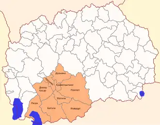
Map of the municipalities of the region
Pelagonia statistical region is divided into 9 municipalities:
- Bitola
- Demir Hisar
- Dolneni
- Krivogaštani
- Kruševo
- Mogila
- Novaci
- Prilep
- Resen
Demographics

Map of the majority ethnic groups in the region
Population
The population of the Pelagonia Statistical Region is 238,136 citizens, or 11.8% of the population of the Republic of North Macedonia, according to the census of 2002.
| Census Year | Population | Change |
|---|---|---|
| 1994 | 214,709 | N/A |
| 2002 | 238,136 | +10.91% |
| 2021 | 210,431 | -11.7% |
Ethnicities
The largest ethnic group in the region are Macedonians (78.22%) followed by the Albanians (6.07%), Roma (3.42%), Turks (3.17%), Bosniaks (1.09%), Vlachs (1.03%).
| 2002 | 2021 | |||
| Number | % | Number | % | |
| TOTAL | 238,136 | 100 | 210,431 | 100 |
| Macedonians | 204,471 | 85.86 | 164,596 | 78.22 |
| Albanians | 11,689 | 4.91 | 12,776 | 6.07 |
| Roma | 7,268 | 3.05 | 7,205 | 3.42 |
| Turks | 7,527 | 3.16 | 6,679 | 3.17 |
| Bosniaks | 2,627 | 1.1 | 2,293 | 1.09 |
| Vlachs | 2,341 | 0.98 | 2,166 | 1.03 |
| Serbs | 869 | 0.36 | 583 | 0.28 |
| Others / Undeclared / Unknown | 1,344 | 0.58 | 1,494 | 0.71 |
| Persons for whom data are taken from administrative sources | 12,639 | 6.01 | ||
See also
- Pelagonia
References
- ↑ "North Macedonia: Statistical Regions & Major Settlements - Population Statistics, Maps, Charts, Weather and Web Information".
- ↑ "Sub-national HDI - Area Database - Global Data Lab". hdi.globaldatalab.org. Retrieved 2018-09-13.
External links
 Media related to Pelagonia Statistical Region at Wikimedia Commons
This article is issued from Wikipedia. The text is licensed under Creative Commons - Attribution - Sharealike. Additional terms may apply for the media files.