Maragheh County
Maragheh County
Persian: شهرستان مراغه | |
|---|---|
 Location of Ahar County in East Azerbaijan province (bottom left, yellow) | |
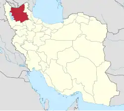 Location of East Azerbaijan province in Iran | |
| Coordinates: 37°23′N 46°27′E / 37.383°N 46.450°E[1] | |
| Country | Iran |
| Province | East Azerbaijan |
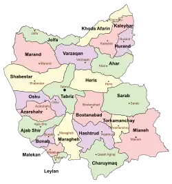
| Capital | Maragheh |
| Districts | Central, Saraju |
| Population (2016)[2] | |
• Total | 262,604 |
| Time zone | UTC+3:30 (IRST) |
| Maragheh County can be found at GEOnet Names Server, at this link, by opening the Advanced Search box, entering "9205877" in the "Unique Feature Id" form, and clicking on "Search Database". | |
Maragheh County (Persian: شهرستان مراغه) is in East Azerbaijan province, Iran. Its capital is the city of Maragheh.[3]
Demographics
Population
At the time of the 2006 National Census, the county's population was 227,635 in 57,612 households.[4] The following census in 2011 counted 247,681 people in 70,842 households.[5] The 2016 census measured the population of the county as 262,604 in 80,261 households.[2]
Administrative divisions
Maragheh County's population history and administrative structure over three consecutive censuses are shown in the following table.
| Administrative Divisions | 2006[4] | 2011[5] | 2016[2] |
|---|---|---|---|
| Central District | 205,137 | 226,310 | 240,972 |
| Qareh Naz RD | 14,491 | 15,720 | 15,602 |
| Sarajuy-ye Gharbi RD | 21,577 | 23,836 | 24,465 |
| Sarajuy-ye Shomali RD | 22,664 | 24,479 | 25,650 |
| Maragheh (city) | 146,405 | 162,275 | 175,255 |
| Saraju District | 22,498 | 21,371 | 21,631 |
| Quri Chay-ye Gharbi RD | 4,382 | 4,023 | 3,641 |
| Sarajuy-ye Jonubi RD | 2,961 | 3,224 | 2,957 |
| Sarajuy-ye Sharqi RD | 13,697 | 12,540 | 13,209 |
| Khodaju (city)[a] | 1,458 | 1,584 | 1,824 |
| Total | 227,635 | 247,681 | 262,604 |
| RD = Rural District | |||
See also
![]() Media related to Maragheh County at Wikimedia Commons
Media related to Maragheh County at Wikimedia Commons
Notes
References
- ↑ OpenStreetMap contributors (4 September 2024). "Maragheh County" (Map). OpenStreetMap (in Persian). Retrieved 4 September 2024.
- 1 2 3 Census of the Islamic Republic of Iran, 1395 (2016): East Azerbaijan Province. amar.org.ir (Report) (in Persian). The Statistical Center of Iran. Archived from the original (Excel) on 13 November 2020. Retrieved 19 December 2022.
- ↑ Habibi, Hassan (c. 2013) [Approved 21 June 1369]. Approval of the organization and chain of citizenship of the elements and units of the country divisions of East Azerbaijan province centered on the city of Tabriz. rc.majlis.ir (Report) (in Persian). Ministry of Interior, Defense Political Commission of the Government Board. Notification 8284/2T142K. Archived from the original on 4 August 2013. Retrieved 4 December 2023 – via Research Center of the System of Laws of the Islamic Council of the Farabi Library of Mobile Users.
- 1 2 Census of the Islamic Republic of Iran, 1385 (2006): East Azerbaijan Province. amar.org.ir (Report) (in Persian). The Statistical Center of Iran. Archived from the original (Excel) on 20 September 2011. Retrieved 25 September 2022.
- 1 2 Census of the Islamic Republic of Iran, 1390 (2011): East Azerbaijan Province. irandataportal.syr.edu (Report) (in Persian). The Statistical Center of Iran. Archived from the original (Excel) on 16 January 2023. Retrieved 19 December 2022 – via Iran Data Portal, Syracuse University.
- ↑ "Shahr Mehr was added to the country's geography map; with five changes in the map of country divisions". Dolat (in Persian). Ministry of the Interior, Political and Defense Commission. 2 March 2011. Archived from the original on 20 April 2017. Retrieved 8 February 2024.
| Capital |  | ||||||||||||||||||||||||||||||||||||||||
|---|---|---|---|---|---|---|---|---|---|---|---|---|---|---|---|---|---|---|---|---|---|---|---|---|---|---|---|---|---|---|---|---|---|---|---|---|---|---|---|---|---|
| Counties and cities |
| ||||||||||||||||||||||||||||||||||||||||
| Landmarks and Sights |
| ||||||||||||||||||||||||||||||||||||||||
| Places |
| ||||||||||||||||||||||||||||||||||||||||
This article is issued from Wikipedia. The text is licensed under Creative Commons - Attribution - Sharealike. Additional terms may apply for the media files.