Lordegan County
Lordegan County
Persian: شهرستان لردگان | |
|---|---|
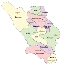 Location of Lordegan County in Chaharmahal and Bakhtiari province (bottom, pink) | |
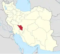 Location of Chaharmahal and Bakhtiari province in Iran | |
| Coordinates: 31°29′N 50°42′E / 31.483°N 50.700°E[1] | |
| Country | |
| Province | Chaharmahal and Bakhtiari |
| Capital | Lordegan |
| Districts | Central, Manj, Rudasht |
| Population (2016)[2] | |
• Total | 209,681 |
| Time zone | UTC+3:30 (IRST) |
| Lordegan County can be found at GEOnet Names Server, at this link, by opening the Advanced Search box, entering "9206273" in the "Unique Feature Id" form, and clicking on "Search Database". | |
Lordegan County (Persian: شهرستان لردگان) is in Chaharmahal and Bakhtiari province, Iran. Its capital is the city of Lordegan.[3]
History
Three villages merged to form the city of Manj-e Nesa in 2011.[4] In the same year, Sardasht Rural District was separated from the Central District in the formation of Talayeh District,[a] including the new Dudera Rural District. In addition, four villages merged in forming the village of Sardasht,[6] which was elevated to the status of a city in 2013.[7]
In 2019, Armand Rural District and Khanmirza District were separated from the county in the establishment of Khanmirza County.[8] Falard District[b] was separated from the county to establish Falard County in 2022.[9]
Demographics
Language
Bakhtiari tribes are predominant inhabitants of Lordegan county. People mainly speak Luri language by Bakhtiari dialect, which is a member of Southwestern Iranian languages.
Population
At the time of the 2006 National Census, the county's population was 175,289, in 34,603 households.[10] The following census in 2011 counted 194,783 people in 44,921 households.[11] The 2016 census measured the population of the county as 209,681 in 54,825 households.[2]
Administrative divisions
Lordegan County's population history and administrative structure over three consecutive censuses are shown in the following table.
| Administrative Divisions | 2006[10] | 2011[11] | 2016[2] |
|---|---|---|---|
| Central District | 96,483 | 110,807 | 105,538 |
| Armand RD[c] | 14,320 | 16,080 | 17,368 |
| Milas RD | 34,258 | 31,092 | 34,885 |
| Rig RD | 12,171 | 13,511 | 12,757 |
| Sardasht RD | 13,006 | 14,848 | |
| Lordegan (city) | 22,728 | 35,276 | 40,528 |
| Falard District[d] | 30,254 | 32,944 | 33,023 |
| Falard RD | 18,723 | 19,671 | 19,918 |
| Poshtkuh RD | 8,569 | 9,575 | 9,081 |
| Mal-e Khalifeh (city) | 2,962 | 3,698 | 4,024 |
| Khanmirza District[c] | 31,320 | 33,000 | 36,360 |
| Javanmardi RD | 9,642 | 10,015 | 10,775 |
| Khanmirza RD | 19,381 | 18,891 | 20,337 |
| Aluni (city) | 2,297 | 4,094 | 5,248 |
| Manj District | 17,232 | 18,032 | 17,998 |
| Barez RD | 8,024 | 8,385 | 7,933 |
| Manj RD | 9,208 | 8,161 | 8,573 |
| Manj-e Nesa (city)[e] | 1,486 | 1,492 | |
| Rudasht District[f] | 16,762 | ||
| Dudera RD | 1,860 | ||
| Sardasht RD | 9,211 | ||
| Sardasht (city)[g] | 5,691 | ||
| Total | 175,289 | 194,783 | 209,681 |
| RD = Rural District | |||
Geography
The Milas Plain (دشت ميلاس)[h] is found in Lordegan County. Wheat, rice and barley are cultivated in the plain.
See also
![]() Media related to Lordegan County at Wikimedia Commons
Media related to Lordegan County at Wikimedia Commons
![]() Iran portal
Iran portal
Notes
- ↑ Renamed Rudasht District[5]
- ↑ Renamed the Central District of Falard County[9]
- 1 2 Transferred to Khanmirza County[8]
- ↑ Transferred to Falard County and renamed the Central District of Falard County[9]
- ↑ Merger of several villages[4]
- ↑ Formerly Talayeh District[5]
- ↑ Merger of several villages[6]
- ↑ Also romanized as Mīlās[12]
References
- ↑ OpenStreetMap contributors (31 August 2024). "Lordegan County" (Map). OpenStreetMap (in Persian). Retrieved 31 August 2024.
- 1 2 3 Census of the Islamic Republic of Iran, 1395 (2016): Chaharmahal and Bakhtiari Province. amar.org.ir (Report) (in Persian). The Statistical Center of Iran. Archived from the original (Excel) on 24 May 2019. Retrieved 19 December 2022.
- ↑ Habibi, Hassan (30 September 2015) [Approved 21 June 1369]. Approval of the organization and chain of citizenship of the elements and units of the national divisions of Chaharmahal and Bakhtiari province, centered in the city of Shahrekord. rc.majlis.ir (Report) (in Persian). Ministry of the Interior, Defense Political Commission of the Government Board. Notification 82826/T124K. Archived from the original on 21 September 2016. Retrieved 2 December 2023 – via Islamic Parliament Research Center.
- 1 2 Rahimi, Mohmmad Reza (14 March 2011). "Four new cities in Chaharmahal and Bakhtiari province were added to the national division map; with some changes in the geography of the country". dolat.ir (in Persian). Ministry of the Interior, Political and Defense Commission. Archived from the original on 28 February 2017. Retrieved 2 December 2023 – via Secretariat of the Government Information Council.
- 1 2 Rahimi, Mohammad Reza (12 October 2013) [Approved 19 July 1391]. Approval letter regarding country divisions in Chaharmahal and Bakhtiari province. rc.majlis.ir (Report) (in Persian). Ministry of the Interior, Political and Defense Commission. Notification 202969/T47210K. Archived from the original on 31 March 2013. Retrieved 2 April 2023 – via Islamic Parliament Research Center of the Islamic Republic of Iran.
- 1 2 Rahimi, Mohammad Reza (c. 2012) [Approved 8 December 1389]. Approval letter regarding country divisions in Chaharmahal and Bakhtiari province. rc.majlis.ir (Report) (in Persian). Ministry of the Interior, Council of Ministers. Proposal 99830/42/1/4/1. Archived from the original on 28 February 2012. Retrieved 23 June 2023 – via Islamic Parliament Research Center of the Islamic Republic of Iran.
- ↑ "Four cities added to Chaharmahal and Bakhtiari province". jamejamonline.ir (in Persian). 3 August 2013. Archived from the original on 9 December 2023. Retrieved 9 March 2025 – via Jam-e Jam Online.
- 1 2 Jahangiri, Ishaq (c. 2019) [Approved 8 December 1397]. Approval letter regarding country divisions in Chaharmahal and Bakhtiari province. rc.majlis.ir (Report) (in Persian). Ministry of the Interior, Council of Ministers. Notification 164881/T55510H. Archived from the original on 21 March 2019. Retrieved 1 April 2023 – via Islamic Parliament Research Center of the Islamic Republic of Iran.
- 1 2 3 Mokhbar, Mohammad (10 August 1401) [Approved 21 April 1401]. The approval letter of the Board of Ministers regarding the national divisions of Chaharmahal and Bakhtiari province was announced. dotic.ir (Report) (in Persian). Ministry of the Interior, Council of Ministers. Notification 64909/T58951H. Archived from the original on 1 August 2022. Retrieved 1 April 2023 – via Laws and Regulations Portal of Iran.
- 1 2 Census of the Islamic Republic of Iran, 1385 (2006): Chaharmahal and Bakhtiari Province. amar.org.ir (Report) (in Persian). The Statistical Center of Iran. Archived from the original (Excel) on 20 September 2011. Retrieved 25 September 2022.
- 1 2 Census of the Islamic Republic of Iran, 1390 (2011): Chaharmahal and Bakhtiari Province. irandataportal.syr.edu (Report) (in Persian). The Statistical Center of Iran. Archived from the original (Excel) on 16 January 2023. Retrieved 19 December 2022 – via Iran Data Portal, Syracuse University.
- ↑ Milas can be found at GEOnet Names Server, at this link, by opening the Advanced Search box, entering "-3075008" in the "Unique Feature Id" form, and clicking on "Search Database".
Chaharmahal and Bakhtiari province, Iran | |||||||||||||||||||||||
|---|---|---|---|---|---|---|---|---|---|---|---|---|---|---|---|---|---|---|---|---|---|---|---|
| Capital |
|  | |||||||||||||||||||||
| Counties and cities |
| ||||||||||||||||||||||
| Landmarks |
| ||||||||||||||||||||||
| populated places |
| ||||||||||||||||||||||