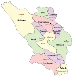
Kuhrang County
Kuhrang County
Persian: شهرستان کوهرنگ | |
|---|---|
 Location of Kuhrang County in Chaharmahal and Bakhtiari province (left, yellow) | |
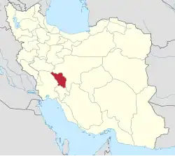 Location of Chaharmahal and Bakhtiari province in Iran | |
| Coordinates: 32°24′N 49°59′E / 32.400°N 49.983°E[1] | |
| Country | |
| Province | Chaharmahal and Bakhtiari |
| Capital | Chelgerd |
| Districts | Central, Bazoft, Doab Samsami |
| Area | |
• Total | 3,709 km2 (1,432 sq mi) |
| Population (2016)[2] | |
• Total | 41,535 |
| • Density | 11/km2 (29/sq mi) |
| Time zone | UTC+3:30 (IRST) |
| Kuhrang County can be found at GEOnet Names Server, at this link, by opening the Advanced Search box, entering "9206272" in the "Unique Feature Id" form, and clicking on "Search Database". | |
Kuhrang County (Persian: شهرستان کوهرنگ) is in Chaharmahal and Bakhtiari province, Iran. Its capital is the city of Chelgerd.[3]
History
In 2009, Bazoft-e Bala Rural District was created in Bazoft District, and Doab Rural District was separated from it in the formation of Doab Samsami District, which was divided into two rural districts, including the new Shahriari Rural District.[4]
The village of Samsami was elevated to the status of a city in 2013,[5] and two villages were merged to form the new city of Bazoft in 2014.[6]
Demographics
Population
At the time of the 2006 National Census, the county's population was 33,468 in 5,980 households.[7] The following census in 2011 counted 35,915 people in 7,702 households.[8] The 2016 census measured the population of the county as 41,535 in 10,859 households.[2]
Administrative divisions
Kuhrang County's population history and administrative structure over three consecutive censuses are shown in the following table.
| Administrative Divisions | 2006[7] | 2011[8] | 2016[2] |
|---|---|---|---|
| Central District | 19,198 | 18,219 | 20,222 |
| Dasht-e Zarrin RD | 7,147 | 7,051 | 7,810 |
| Miankuh-e Moguyi RD | 3,781 | 3,570 | 3,992 |
| Shurab-e Tangazi RD | 5,562 | 4,537 | 5,431 |
| Chelgerd (city) | 2,708 | 3,061 | 2,989 |
| Bazoft District | 14,270 | 12,185 | 14,742 |
| Bazoft-e Bala RD | 3,305 | 4,144 | |
| Bazoft-e Pain RD[a] | 8,526 | 8,880 | 9,079 |
| Doab RD | 5,744 | ||
| Bazoft (city)[b] | 1,519 | ||
| Doab Samsami District | 4,065 | 5,930 | |
| Doab RD | 3,558 | 3,353 | |
| Shahriari RD | 507 | 1,374 | |
| Samsami (city) | 1,203 | ||
| Total | 33,468 | 35,915 | 41,535 |
| RD = Rural District | |||
Infrastructure
The county is the site of three dams and tunnels transferring water from the Kuhrang River to the Zayandeh River: Kouhrang 1, Kouhrang 2, and Kouhrang 3
Tourism
Kuhrang County has many tourist attractions based on its environmental diversity, such as Kuhrang Spring, ice caves, Sheikh Ali Khan waterfall, and Dimeh Spring. The people of this county are Bakhtiari and speak Luri.
See also
![]() Media related to Kuhrang County at Wikimedia Commons
Media related to Kuhrang County at Wikimedia Commons
![]() Iran portal
Iran portal
Notes
References
- ↑ OpenStreetMap contributors (30 August 2024). "Kuhrang County" (Map). OpenStreetMap (in Persian). Retrieved 30 August 2024.
- 1 2 3 Census of the Islamic Republic of Iran, 1395 (2016): Chaharmahal and Bakhtiari Province. amar.org.ir (Report) (in Persian). The Statistical Center of Iran. Archived from the original (Excel) on 24 May 2019. Retrieved 19 December 2022.
- ↑ Habibi, Hassan (c. 2023) [Approved 27 April 1380]. Approval letter regarding the establishment of Kuhrang County. lamtakam.com (Report) (in Persian). Ministry of the Interior, Council of Ministers. Proposal 1.4.42.3141. Archived from the original on 3 December 2023. Retrieved 3 December 2023 – via Lam ta Kam.
- 1 2 Rahimi, Mohammad Reza (c. 2023) [Approved 29 July 1388]. Approval letter regarding division reforms in Chaharmahal and Bakhtiari province. lamtakam.com (Report) (in Persian). Ministry of the Interior, Political and Defense Commission. Notification 153293/T35140K. Archived from the original on 3 December 2023. Retrieved 3 December 2023 – via Lam ta Kam.
- ↑ "Four cities added to Chaharmahal and Bakhtiari province". jamejamonline.ir (in Persian). 3 August 2013. Archived from the original on 9 December 2023. Retrieved 9 March 2025 – via Jam-e Jam Online.
- 1 2 "Bazoft District". koohrang.ostan-chb.ir (in Persian). 29 August 2019. Archived from the original on 30 July 2019. Retrieved 9 March 2025 – via Kuhrang County Governorate.
- 1 2 Census of the Islamic Republic of Iran, 1385 (2006): Chaharmahal and Bakhtiari Province. amar.org.ir (Report) (in Persian). The Statistical Center of Iran. Archived from the original (Excel) on 20 September 2011. Retrieved 25 September 2022.
- 1 2 Census of the Islamic Republic of Iran, 1390 (2011): Chaharmahal and Bakhtiari Province. irandataportal.syr.edu (Report) (in Persian). The Statistical Center of Iran. Archived from the original (Excel) on 16 January 2023. Retrieved 19 December 2022 – via Iran Data Portal, Syracuse University.
Chaharmahal and Bakhtiari province, Iran | |||||||||||||||||||||||
|---|---|---|---|---|---|---|---|---|---|---|---|---|---|---|---|---|---|---|---|---|---|---|---|
| Capital |
|  | |||||||||||||||||||||
| Counties and cities |
| ||||||||||||||||||||||
| Landmarks |
| ||||||||||||||||||||||
| populated places |
| ||||||||||||||||||||||