Hungary–Ukraine border
| Hungary–Ukraine border | |
|---|---|
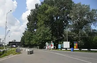 Checkpoint at the border | |
| Characteristics | |
| Entities | |
| Length | 103 km (64 mi) |
| History | |
| Established | 1920 1991 Signing of the Treaty of Trianon at the end of the World War I Declaration of Independence of Ukraine |
| Current shape | 1947 Paris Peace Treaties |
| Treaties | Paris Peace Treaties (1947) |
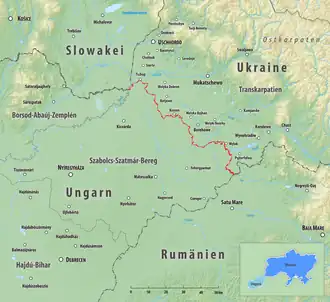
Hungarian–Ukraine border (red)
The Hungary–Ukraine border (Hungarian: magyar–ukrán államhatár; Ukrainian: Угорсько-український кордон) is an internationally established boundary between Hungary and Ukraine. The modern border remains unchanged since the end of the World War II. The current border was established after World War II when Zakarpattia Oblast was admitted into Ukraine, which at the time was part of the Soviet Union as the Ukrainian Soviet Socialist Republic. The border stretches for 136.7 km (84.9 mi) along the Tisza river valley.[1][2]
After the admission of Hungary to the European Union, the border security became the responsibility of the union, as well.
Border checkpoints
Hungarian and Ukrainian boundary markers
- Road
| Chop | M25 | Záhony | ||||
| Vylok | M26 | Tiszabecs | ||||
| Luzhanka | M24 | Beregsurány | ||||
| Dzvinkove | Lónya | |||||
| Kosyno | M25 | Barabás |
- Rail
| Chop | — | Záhony | |||
| Solovka | — | Eperjeske | freight only |
See also
- State Border of Ukraine
- Hungary–Ukraine relations
- Zakarpattia Lowland
References
- ↑ Erőss, Ágnes; Kovály, Katalin; Tátrai, Partrik (2016). Effects of the Ukrainian Crisis in Transcarpathia: The Hungarian Perspective (PDF). CMR Working Papers, No. 92/150. University of Warsaw, Centre of Migration Research (CMR). p. 17. hdl:10419/180979.
- ↑ ICPDR (2008). Analysis of the Tisza River Basin 2007 (PDF) (Report). ICPDR – International Commission for the Protection of the Danube River.
External links
Wikimedia Commons has media related to Hungary-Ukraine border.
This article is issued from Wikipedia. The text is licensed under Creative Commons - Attribution - Sharealike. Additional terms may apply for the media files.