Hungary–Romania border
| Hungary–Romania border | |
|---|---|
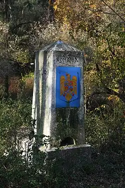
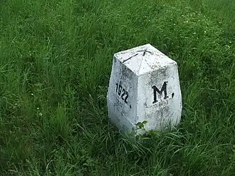 Border marker between Hungary and Romania at Csenger | |
| Characteristics | |
| Entities | |
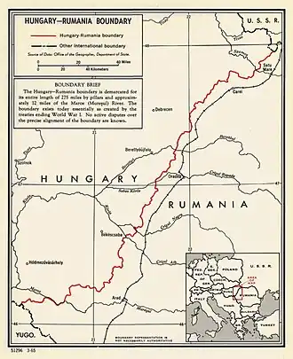
| Length | 448 km (278 mi) |
| History | |
| Established | 1920 Signing of the Treaty of Trianon at the end of the World War I |
| Current shape | 1947 Paris Peace Treaties |
| Treaties | Treaty of Trianon (1920) Second Vienna Award (1940) Paris Peace Treaties (1947) |
The Hungary–Romania border (Hungarian: Magyar–Román Államhatár; Romanian: Frontiera între Ungaria și România) refers to the state border between Hungary and Romania. It was established in 1920 by an international commission, the "Lord Commission", presided over by geographers including Emmanuel de Martonne and Robert Ficheux, and historians Robert William Seton-Watson and Ernest Denis. The border was set by the Treaty of Trianon which was signed on 4 June 1920.[1][2]
The border has been stable since the end of the Second World War, when it received its current shape, and is no longer officially in dispute between the countries. In the current form, the border is about 448 kilometers long, or about 278 miles. It is demarcated by pillars, and about 20 kilometers of the border are marked by the Mureș River (”Maros” in Hungarian).[3]
At the moment, the border is an internal border of the European Union, using to be an external border of it after Hungary's accession to the alliance on May 1, 2004. Romania followed suit, and became a member state of the European Union on January 1, 2007, making the border becoming an internal border of it. Both countries later joined the Schengen Area (Hungary on December 21, 2007 and Romania on January 1, 2025), making the border just a formality as transit between the two neighbouring countries is now open.[4]
History
Prior to World War I, the eastern and southern Carpathian Mountains formed a natural border between the Austro-Hungarian Empire and Romania.[5]
Hungary and Romania became belligerents in World War I as Romania entered the war in 1916 on the side of the Allies. During that war the part of Transylvania south of the Maros (Mureș) and east of the Szamos (Someș) had been occupied by Romania forces at the time of the cease-fire agreement of Belgrade signed on 13 November 1918.[6] On 1 December 1918, the Great National Assembly of Alba Iulia declared union with the Kingdom of Romania. Subsequently, the Romanian forces moved further into Hungary and occupied Budapest from August to mid-November 1919.[7]
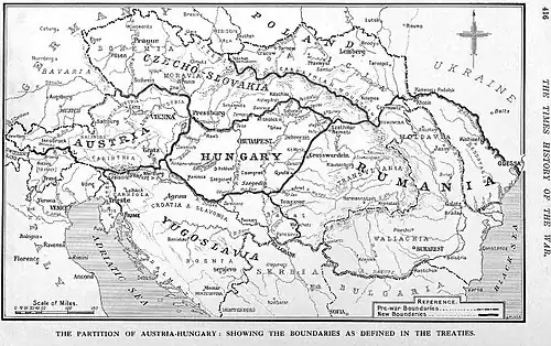
The Treaty of Trianon finalized the armistice between the Allies and Hungary.[8] In the treaty Romania recovered all of Transylvania (including parts of Maramureș, Banat and Crișana),[9][10]
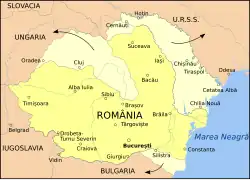
Briefly during World War II, Northern Transylvania (including part of Maramureș and Crișana) was returned to Hungary under the Second Vienna Award in 1940.[11][12] In 1944 as World War II drew to a close and Romania joined the war against Germany, the Allies agreed de facto to the Trianon boundaries, and this was confirmed at the Paris Peace Conference in 1946, and by the subsequent peace treaties formalized in 1947.[12][13]
Geography
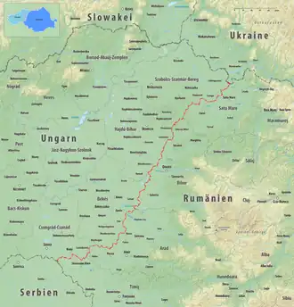
The Hungarian–Romanian border begins at a tripoint located in the historical region of the Banat, 15 km (9.3 mi) south-east of the Hungarian town of Szeged, where the border between Hungary and Serbia intersects the land border between Romania and Serbia. It generally runs south-south-westwards/north-north-eastwards across the Pannonian Basin to another tripoint located on the Tur river, 16 km (9.9 mi) north of the Romanian town of Satu Mare, where the Hungarian-Ukrainian border intersects the land border between Romania and Ukraine.
Counties along the border
Both countries use counties as the second form of administrative division. Four Hungarian and four Romanian counties sit along the border.
Hungarian counties
From north to south, the Hungarian counties bordering Romania are:
- Szabolcs–Szatmár–Bereg, bordering the Romanian counterparts Satu Mare and Bihor (narrowly) counties.
- Hajdú–Bihar, bordering the Romanian counterpart Bihor county.
- Békés, bordering the Romanian counterparts Bihor and Arad counties almost evenly.
- Csongrád-Csanád, bordering the Romanian counterparts Arad (narrowly) and Timiș counties.
Romanian counties
From north to south, the Romanian counties bordering Hungary are:
- Satu Mare, bordering the Hungarian counterpart Szabolcs–Szatmár–Bereg county
- Bihor, bordering the Hungarian counterparts Szabolcs–Szatmár–Bereg (narrowly), Hajdú–Bihar and Békés counties.
- Arad, bordering the Hungarian counterparts Békés and Csongrád-Csanád (narrowly) counties.
- Timiș, bordering the Hungarian counterpart Csongrád-Csanád county.
Border crossings
Road
| Opened | Type of road | Route in Hungary | Route in Romania | Notes | ||
|---|---|---|---|---|---|---|
| Garbolc | Bercu | October 2013 | local road | 41134 | Dj194 | Planned after Romania joining the Schengen Area |
| Zajta | Peleș | 41135 | DC63 | Temporary crossing | ||
| Csengersima | Dorolț (Petea) | main road | ||||
| Csenger | Oar | planned | highway | planned highway | ||
| Vállaj | Urziceni | local/main road | 4915 | |||
| Ömböly | Horea | 49133 | Dj196C | Planned after Romania joining the Schengen Area | ||
| Nyírábrány | Valea lui Mihai | main road | ||||
| Bagamér | Șimian (Voivozi) | DC7 | Temporary crossing | |||
| Létavértes | Săcuieni | local/main road | 4814 | |||
| Pocsaj | Roșiori | DC19 | Temporary crossing | |||
| Nagykereki | Borș II | 4 September 2020[14] | highway | Part of | ||
| Ártánd | Borș | main road | ||||
| Körösnagyharsány | Cheresig | 42156 | Dj797 | Planned after Romania joining the Schengen Area | ||
| Méhkerék | Salonta | local/main road | 4252 | |||
| Gyula (Dénesmajor) | Iermata Neagră | local road | 42146 | DC119 | Temporary crossing | |
| Gyula | Vărșand | main road | ||||
| Elek | Grăniceri | local road | 4435 | Dj709B | Temporary crossing | |
| Dombegyház | Variașu Mic | 11 December 2013 | local road | 4439 | Dj709C | Planned after Romania joining the Schengen Area |
| Battonya | Pecica (Turnu) | local/main road | 4455 | |||
| Csanádpalota | Nădlac II | 13 July 2015[15] | highway | Part of | ||
| Nagylak | Nădlac | main road | ||||
| Kiszombor | Cenad | main road | vehicle only <7,5t |
Rail
All railway crossings are standard gauge. As of June 2019, all railway crossings have passenger traffic.
- Tiborszállás – Carei; last train: 9 December 2023
- Nyírábrány – Valea lui Mihai
- Biharkeresztes – Episcopia Bihor; electrified 25 kV 50 Hz
- Kötegyán – Salonta
- Lőkösháza – Curtici; electrified 25 kV 50 Hz, double-track line
See also
- Hungary–Romania relations
- Union of Hungary and Romania
References
- ↑ "In Memoriam Robert Ficheux, francezul care a iubit, cu o fidelitate neasemuită, România". Radio România Iași (in Romanian). 2 August 2021. Retrieved 28 May 2022.
- ↑ Lowczyk Olivier, (2010) La fabrique de la paix. Du Comité d'études à la Conférence de la paix, l'élaboration par la France des traités de la Première Guerre mondiale, Paris, Economica, Coll. Bibliothèque stratégique, (in French).
- ↑ Linden, Ronald H. (2000). "Putting on Their Sunday Best: Romania, Hungary, and the Puzzle of Peace". International Studies Quarterly. 44 (1): 121–145. doi:10.1111/0020-8833.00151. JSTOR 3013972.
- ↑ "Romania's Schengen accession set to strengthen ties with Hungary". Euronews. 20 December 2024.
- ↑ Roeder, Carolin F. (2020). "From Neo-Slavism to Internationalism: Interwar Central Europe and the Search for the Lost Mountains" (PDF). Contemporary European History. 29: 16–29, page 22, footnote 28. doi:10.1017/S0960777319000171. S2CID 210545482.
- ↑ Krizman, Bogdan (1970). "The Belgrade Armistice of 13 November 1918". The Slavonic and East European Review. 48 (110): 67–87. JSTOR 4206164.
- ↑ "Treaty of Trianon". Encyclopedia Britannica. 2020.
- ↑ "Treaty of Peace Between The Allied and Associated Powers and Hungary And Protocol and Declaration, Signed at Trianon June 4, 1920". Brigham Young University. Retrieved 3 June 2020.
- ↑ Bardócz, Lászlóné; et al. (1998). Történelmi világatlasz [World Atlas of History] (in Hungarian). Budapest: Cartographia. ISBN 963-352-519-5.
- ↑ Hupchick, Dennis P.; Cox, Harold E. (2016). "Map 45: Romania after Trianon 1920–1938". The Palgrave Concise Historical Atlas of Eastern Europe. Springer Verlag. pp. 63–64. ISBN 978-1-137-04817-2.
- ↑ Ablonczy, Balázs (2011). A visszatért Erdély 1940–1944 [The returned Transylvania 1940–1944] (in Hungarian). Budapest: Jaffa Kiadó. ISBN 978-963-9971-60-8.
- 1 2 Hupchick, Dennis P.; Cox, Harold E. (2016). "Map 46: The Transylvanian Question". The Palgrave Concise Historical Atlas of Eastern Europe. Springer Verlag. pp. 65–66. ISBN 978-1-137-04817-2.
- ↑ Vago, Raphael (1989). The Grandchildren of Trianon: Hungary and the Hungarian Minority in the Communist States. Boulder, Colorado: East European Monographs. p. 25. ISBN 978-0-88033-155-5.
- ↑ "Átadták a nagykereki új autópálya-határátkelőt" (in Hungarian). 4 September 2020. Retrieved 22 December 2024.
- ↑ "Elkészült az M43-as autópálya az országhatárig" (in Hungarian). 13 July 2015. Retrieved 22 December 2024.