Boluran
Boluran
Persian: بلوران | |
|---|---|
Village | |
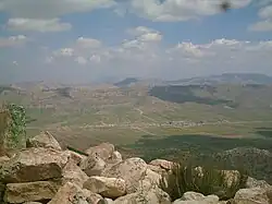 Boluran village from the summit of Boluran Mountain | |
 Boluran | |
| Coordinates: 33°33′23″N 47°18′04″E / 33.55639°N 47.30111°E[1] | |
| Country | Iran |
| Province | Lorestan |
| County | Kuhdasht |
| District | Darb-e Gonbad |
| Rural District | Boluran |
| Elevation | 1,505 m (4,938 ft) |
| Population (2016)[2] | |
• Total | 742 |
| Time zone | UTC+3:30 (IRST) |
| Area code | (+98) 066 |
Boluran (Persian: بلوران)[a] is a village in, and the capital of, Boluran Rural District of Darb-e Gonbad District, Kuhdasht County, Lorestan province, Iran.[4] The village is located 35 km west of Kuhdasht.[5] Boluran's residents speak Laki and the predominant religion is Yarsanism.[6]
Demographics
Population
At the time of the 2006 National Census, the village's population was 1,334 in 292 households.[7] The following census in 2011 counted 947 people in 246 households.[8] The 2016 census measured the population of the village as 742 people in 217 households. It was the most populous village in its rural district.[2]
Boluran Forest Park
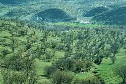
Boluran Forest Park is a park in Kuhdasht. The park suffered extensive forest fire damage. In 2016, a large fire raged for days, damaging hundreds of acres of land.
Gallery
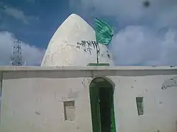 The Shrine of Agha Mirza Hossein (the summit of Boluran mountain).
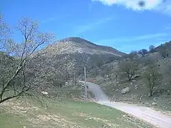 Boluran mountain.
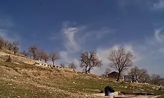 The Historical cemetery on the mountainside of Boluran.
See also
![]() Iran portal
Iran portal
Notes
References
- ↑ OpenStreetMap contributors (2 January 2025). "Boluran, Kuhdasht County" (Map). OpenStreetMap (in Persian). Retrieved 2 January 2025.
- 1 2 Census of the Islamic Republic of Iran, 1395 (2016): Lorestan Province. amar.org.ir (Report) (in Persian). The Statistical Center of Iran. Archived from the original (Excel) on 12 October 2020. Retrieved 19 December 2022.
- ↑ Boluran can be found at GEOnet Names Server, at this link, by opening the Advanced Search box, entering "-3056601" in the "Unique Feature Id" form, and clicking on "Search Database".
- ↑ Aref, Mohammadreza (c. 2023) [Approved 27 November 1381]. Divisional reforms in Lorestan province. qavanin.ir (Report) (in Persian). Ministry of the Interior, Political-Defense Commission of the Government Board. Proposal 92680/42/1; Letter 58538/T26118H. Archived from the original on 23 August 2023. Retrieved 20 January 2024 – via Laws and Regulations Portal of the Islamic Republic of Iran.
- ↑ "Google Maps". Google Maps. Retrieved 3 January 2020.
- ↑ محمدیان فخرالدین; کاخکی احمد; نورو ززاده چگینی ناصر (2016). "فرایند و چگونگی شکل گیری معماری آیینی یارسان" (PDF). انتشارات پژوهشگاه میراث فرهنگی و گردشگری. 37 (72): 93–108. Retrieved 5 April 2020.
- ↑ Census of the Islamic Republic of Iran, 1385 (2006): Lorestan Province. amar.org.ir (Report) (in Persian). The Statistical Center of Iran. Archived from the original (Excel) on 20 September 2011. Retrieved 25 September 2022.
- ↑ Census of the Islamic Republic of Iran, 1390 (2011): Lorestan Province. irandataportal.syr.edu (Report) (in Persian). The Statistical Center of Iran. Archived from the original (Excel) on 19 January 2023. Retrieved 19 December 2022 – via Iran Data Portal, Syracuse University.
Lorestan province, Iran | |||||||||||||||||||||||
|---|---|---|---|---|---|---|---|---|---|---|---|---|---|---|---|---|---|---|---|---|---|---|---|
| Capital |
|  | |||||||||||||||||||||
| Counties and cities |
| ||||||||||||||||||||||
| Sights |
| ||||||||||||||||||||||
| populated places |
| ||||||||||||||||||||||