Khorramabad County
Khorramabad County
Persian: شهرستان خرمآباد | |
|---|---|
 | |
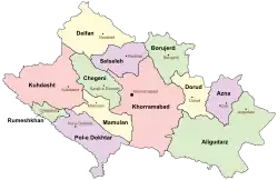 Location of Khorramabad County in Lorestan province (center, pink) | |
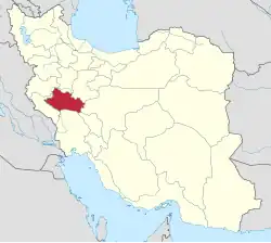 Location of Lorestan province in Iran | |
| Coordinates: 33°21′N 48°31′E / 33.350°N 48.517°E[1] | |
| Country | Iran |
| Province | Lorestan |
| Capital | Khorramabad |
| Districts | Central, Beyranvand, Papi, Zagheh |
| Population (2016)[2] | |
• Total | 506,471 |
| Time zone | UTC+3:30 (IRST) |
| Khorramabad County can be found at GEOnet Names Server, at this link, by opening the Advanced Search box, entering "9207199" in the "Unique Feature Id" form, and clicking on "Search Database". | |
Khorramabad County (Persian: شهرستان خرمآباد) is in Lorestan province, Iran. Its capital is the city of Khorramabad.[3]
History
After the 2006 National Census, Chegeni[a] and Veysian Districts were separated from the county to form Dowreh County.[5][b]
Demographics
Population
At the time of the 2006 census, the county's population was 509,251 in 113,886 households.[7] The following census in 2011 counted 487,167 people in 128,600 households.[8] The 2016 census measured the population of the county as 506,471 in 144,958 households.[2]
Administrative divisions
Khorramabad County's population history and administrative structure over three consecutive censuses are shown in the following table.
| Administrative Divisions | 2006[7] | 2011[8] | 2016[2] |
|---|---|---|---|
| Central District | 417,556 | 445,627 | 463,599 |
| Azna RD | 6,214 | 6,190 | 5,859 |
| Dehpir-e Jonubi RD | 7,479 | 9,659 | 10,258 |
| Dehpir-e Shomali RD | 6,332 | 6,108 | 6,082 |
| Kakasharaf RD | 4,091 | 3,627 | 2,742 |
| Koregah-e Gharbi RD[c] | 45,409 | 50,971 | 42,884 |
| Koregah-e Sharqi RD | 11,294 | 12,456 | 11,759 |
| Robat RD | 8,193 | 8,400 | 10,599 |
| Khorramabad (city) | 328,544 | 348,216 | 373,416 |
| Beyranvand District[d] | 11,378 | 10,879 | 12,003 |
| Beyranvand-e Jonubi RD | 6,309 | 5,994 | 6,547 |
| Beyranvand-e Shomali RD | 3,525 | 3,476 | 3,736 |
| Beyranshahr (city)[e] | 1,544 | 1,409 | 1,720 |
| Chegeni District[f] | 31,117 | ||
| Dowreh RD | 9,208 | ||
| Kashkan RD[g] | 10,294 | ||
| Teshkan RD | 10,303 | ||
| Sarab-e Dowreh (city) | 1,312 | ||
| Papi District | 16,898 | 13,514 | 12,204 |
| Chamsangar RD | 2,520 | 1,942 | 1,675 |
| Gerit RD | 2,145 | 1,876 | 1,539 |
| Keshvar RD | 1,873 | 1,379 | 1,206 |
| Sepiddasht RD | 5,117 | 3,741 | 3,610 |
| Tang-e Haft RD | 2,046 | 2,031 | 1,257 |
| Sepiddasht (city) | 3,197 | 2,545 | 2,917 |
| Veysian District[h] | 13,029 | ||
| Shurab RD | 5,081 | ||
| Veysian RD | 6,131 | ||
| Veysian (city)[i] | 1,817 | ||
| Zagheh District | 19,273 | 16,869 | 17,440 |
| Qaedrahmat RD | 7,381 | 6,449 | 6,108 |
| Razan RD | 3,102 | 2,052 | 3,260 |
| Zagheh RD | 5,951 | 5,683 | 5,296 |
| Zagheh (city) | 2,839 | 2,685 | 2,776 |
| Total | 509,251 | 487,167 | 506,471 |
| RD = Rural District | |||
Demographics
Language
The city's population is mainly Lur and kurdish Lak.[11][12]
See below, the linguistic composition of the city:[13]
Colleges and universities
See also
![]() Media related to Khorramabad County at Wikimedia Commons
Media related to Khorramabad County at Wikimedia Commons
Notes
- ↑ Formerly Dowreh-ye Chegeni District[3] and renamed the Central District of Chegeni County[4]
- ↑ Renamed Chegeni County[6]
- ↑ Formerly Koregah Rural District[9]
- ↑ Formerly Chaghalvandi District[10]
- ↑ Formerly Chaghalvandi[10]
- ↑ Formerly Dowreh-ye Chegeni District;[3] transferred to Dowreh County,[6]
- ↑ Renamed Kashkan-e Shomali Rural District[5]
- ↑ Transferred to Dowreh County,[5] later renamed Chegeni County[6]
- ↑ Formerly Mahmudvand[5]
References
- ↑ OpenStreetMap contributors (1 January 2025). "Khorramabad County" (Map). OpenStreetMap (in Persian). Retrieved 1 January 2025.
- 1 2 3 Census of the Islamic Republic of Iran, 1395 (2016): Lorestan Province. amar.org.ir (Report) (in Persian). The Statistical Center of Iran. Archived from the original (Excel) on 12 October 2020. Retrieved 19 December 2022.
- 1 2 3 Approval of the organization and chain of citizenship of the elements and units of the country divisions of Lorestan province, centered in the city of Khorramabad. lamtakam.com (Report) (in Persian). Ministry of the Interior, Political and Defense Commission of the Government Board. c. 2024 [Approved 21 June 1369]. Proposal 3233.1.5.53; Letter 907-93808; Notification 82816/T121K. Archived from the original on 19 January 2024. Retrieved 19 January 2024 – via Lam ta Kam.
- ↑ Vahidi, Ahmad (17 December 2023). "The name of Chegeni District was changed to Central". yaftenews.ir (in Persian). Ministry of the Interior, Cabinet of Ministers. Archived from the original on 3 January 2024. Retrieved 31 December 2024 – via Yafteh.
- 1 2 3 4 Davodi, Parviz (c. 2015) [Approved 29 July 1386]. Approval letter regarding the reforms of country divisions in Lorestan province. law.dotic.ir (Report) (in Persian). Ministry of the Interior, Cabinet of Ministers. Proposal 93023/42/1/1; Letter 58538/T26118AH. Archived from the original on 29 September 2015. Retrieved 24 August 2023 – via Laws and Regulations Portal of the Islamic Republic of Iran.
- 1 2 3 Jahangiri, Ishaq (14 April 2019) [Approved 22 December 1397]. Approval regarding national divisions in the provinces of West Azerbaijan, Ardabil, Isfahan, Bushehr, Sistan and Baluchestan, Fars, Qom, Lorestan, Mazandaran. sdil.ac.ir (Report) (in Persian). Ministry of the Interior, Cabinet of Ministers. Proposal 158389; Notification 175033/T56016H. Archived from the original on 29 June 2019. Retrieved 29 January 2025 – via Shahr Danesh Legal Research Institute.
- 1 2 Census of the Islamic Republic of Iran, 1385 (2006): Lorestan Province. amar.org.ir (Report) (in Persian). The Statistical Center of Iran. Archived from the original (Excel) on 20 September 2011. Retrieved 25 September 2022.
- 1 2 Census of the Islamic Republic of Iran, 1390 (2011): Lorestan Province. irandataportal.syr.edu (Report) (in Persian). The Statistical Center of Iran. Archived from the original (Excel) on 19 January 2023. Retrieved 19 December 2022 – via Iran Data Portal, Syracuse University.
- ↑ Habibi, Hassan (c. 2023) [Approved 16 April 1372]. Carrying out reforms in the villages of Lorestan province. qavanin.ir (Report) (in Persian). Ministry of the Interior, Political-Defense Commission of the Government Board. Proposal 4/42/1889/1; Resolution 93808/T907. Archived from the original on 23 August 2023. Retrieved 22 January 2024 – via Laws and Regulations Portal of the Islamic Republic of Iran.
- 1 2 Rahimi, Mohammadreza (14 August 2017). "Six changes in the map of the national divisions of Lorestan and Sistan and Baluchestan provinces". dolat.ir (in Persian). Ministry of the Interior, Political and Defense Commission. Archived from the original on 4 August 2018. Retrieved 16 April 2023 – via Secretariat of the Government Information Council.
- ↑ Anonby, Erik John "Update on Luri: How many languages" Archived 2015-05-01 at the Wayback Machine JRAS (Journal of the Royal Asiatic Society) Series 3 13(2): pp. 171–197, p.183, doi:10.1017/S1356186303003067
- ↑ "Khorramabad is the largest city of Lurs" (in Persian). Yafte news agancy. 18 April 2018. Retrieved 22 April 2021.
- ↑ "Language distribution: individual languages and language families". Iran Atlas. Retrieved 15 September 2023.
- ↑ Lorestan University" homepage, in English Archived September 20, 2010, at the Wayback Machine
- ↑ "Lorestan University of Medical Sciences homepage". Lums.ac.ir. Retrieved 12 September 2012.
- ↑ "afpkh.ir". afpkh.ir. Archived from the original on 11 September 2012. Retrieved 12 September 2012.
Lorestan province, Iran | |||||||||||||||||||||||
|---|---|---|---|---|---|---|---|---|---|---|---|---|---|---|---|---|---|---|---|---|---|---|---|
| Capital |
|  | |||||||||||||||||||||
| Counties and cities |
| ||||||||||||||||||||||
| Sights |
| ||||||||||||||||||||||
| populated places |
| ||||||||||||||||||||||