Abbasabad County
Abbasabad County
Persian: شهرستان عباسآباد | |
|---|---|
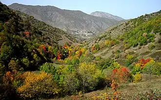 Abbasabad County in the fall | |
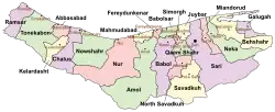 Location of Abbasabad County in Mazandaran province (left, pink) | |
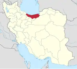 Location of Mazandaran province in Iran | |
| Coordinates: 36°39′N 51°10′E / 36.650°N 51.167°E[1] | |
| Country | Iran |
| Province | Mazandaran |
| Capital | Abbasabad |
| Districts | Central, Kelar, Salman Shahr |
| Population (2016)[2] | |
• Total | 52,832 |
| Time zone | UTC+3:30 (IRST) |
Abbasabad County (Persian: شهرستان عباسآباد) is in Mazandaran province, Iran. Its capital is the city of Abbasabad.[3]
History
After the 2006 National Census, Abbasabad District was separated from Tonekabon County in the establishment of Abbasabad County, which was divided into two districts of two rural districts each, with Abbasabad as its capital.[3]
After the 2011 census, Kelarabad-e Sharqi Rural District[a] and the city of Kelarabad were separated from Kelarabad District in the formation of Kelar District, which was divided into two rural districts, including the new Kelar-e Gharbi Rural District. Kelarabad District was renamed Salmanshahr District.[4]
Demographics
Population
At the time of the 2011 census, the county's population was 47,591 people in 14,568 households.[5] The 2016 census measured the population of the county as 52,832 in 17,345 households.[2]
Administrative divisions
Abbasabad County's population history and administrative structure over two consecutive censuses are shown in the following table.
| Administrative Divisions | 2011[5] | 2016[2] |
|---|---|---|
| Central District | 22,946 | 25,436 |
| Langarud-e Gharbi RD | 2,818 | 3,011 |
| Langarud-e Sharqi RD[b] | 8,529 | 8,943 |
| Abbasabad (city) | 11,599 | 13,482 |
| Kelar District | 10,969 | |
| Kelar-e Gharbi RD | 2,293 | |
| Kelar-e Sharqi RD[c] | 2,409 | |
| Kelarabad (city) | 6,267 | |
| Salmanshahr District[d] | 24,645 | 16,427 |
| Kelarabad-e Gharbi RD[e] | 5,804 | 6,771 |
| Kelarabad-e Sharqi RD[f] | 4,261 | |
| Kelarabad (city) | 5,926 | |
| Salman Shahr (city) | 8,654 | 9,656 |
| Total | 47,591 | 52,832 |
| RD = Rural District | ||
See also
![]() Media related to Abbasabad County at Wikimedia Commons
Media related to Abbasabad County at Wikimedia Commons
Notes
- ↑ Renamed Kelar-e Sharqi Rural District[4]
- ↑ Formerly Langarud Rural District[3]
- ↑ Formerly Kelarabad-e Sharqi Rural District[4]
- ↑ Formerly Kelarabad District[4]
- ↑ Formerly Kelarabad Rural District[3]
- ↑ Renamed Kelar-e Sharqi Rural District[4]
References
- ↑ OpenStreetMap contributors (19 October 2024). "Abbasabad County" (Map). OpenStreetMap (in Persian). Retrieved 19 October 2024.
- 1 2 3 Census of the Islamic Republic of Iran, 1395 (2016): Mazandaran Province. amar.org.ir (Report) (in Persian). The Statistical Center of Iran. Archived from the original (Excel) on 7 October 2021. Retrieved 19 December 2022.
- 1 2 3 4 Davodi, Parviz (c. 2023) [Approved 3 March 1388]. Divisional reforms and changes in Mazandaran province. qavanin.ir (Report) (in Persian). Ministry of the Interior, Board of Ministers. Proposal 154154/42/4/1. Archived from the original on 20 May 2023. Retrieved 20 May 2023 – via Laws and Regulations Portal of the Islamic Republic of Iran.
- 1 2 3 4 5 Rahimi, Mohammad Reza (c. 2023) [Approved 11 September 2011]. Divisional reforms in Mazandaran province. qavanin.ir (Report) (in Persian). Ministry of the Interior, Defense Political Commission of the Government Board. Proposals 5622/42/1/4, 144980/42/4/1, and 40794/42/1/4. Archived from the original on 22 May 2023. Retrieved 22 May 2023 – via Laws and Regulations Portal of the Islamic Republic of Iran.
- 1 2 Census of the Islamic Republic of Iran, 1390 (2011): Mazandaran Province. irandataportal.syr.edu (Report) (in Persian). The Statistical Center of Iran. Archived from the original (Excel) on 19 January 2023. Retrieved 19 December 2022 – via Iran Data Portal, Syracuse University.
| Capital | |||||||||||||||||
|---|---|---|---|---|---|---|---|---|---|---|---|---|---|---|---|---|---|
| Districts |
| ||||||||||||||||