Zanjan County
Zanjan County
Persian: شهرستان زنجان | |
|---|---|
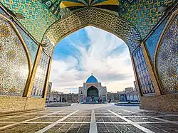 Jeme'h Mosque of Zanjan | |
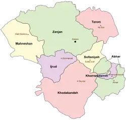 Location of Zanjan County in Zanjan province (top, green) | |
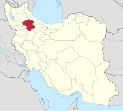 Location of Zanjan province in Iran | |
| Coordinates: 36°51′N 48°10′E / 36.850°N 48.167°E[1] | |
| Country | Iran |
| Province | Zanjan |
| Capital | Zanjan |
| Districts | Central, Qareh Poshtelu, Zanjanrud |
| Population (2016)[2] | |
• Total | 521,302 |
| Time zone | UTC+3:30 (IRST) |
| Zanjan County can be found at GEOnet Names Server, at this link, by opening the Advanced Search box, entering "-3197431" in the "Unique Feature Id" form, and clicking on "Search Database". | |
Zanjan County (Persian: شهرستان زنجان) is in Zanjan province, Iran. Its capital is the city of Zanjan.[3]
History
The village of Armaghankhaneh was elevated to the status of a city in 2009,[4] and the village of Nik Pey became a city in 2011.[5] Soharin Rural District was created in Qareh Poshtelu District in 2013.[6]
Demographics
Population
At the time of the 2006 National Census, the Zanjan County's population was 442,728 in 113,883 households.[7] The following census in 2011 counted 486,495 people in 137,832 households.[8] The 2016 census measured the population of the county as 521,302 in 159,020 households.[2]
Administrative divisions
Zanjan County's population history and administrative structure over three consecutive censuses are shown in the following table.
| Administrative Divisions | 2006[7] | 2011[8] | 2016[2] |
|---|---|---|---|
| Central District | 395,149 | 442,924 | 482,025 |
| Bonab RD | 11,782 | 13,665 | 14,146 |
| Bughda Kandi RD | 8,586 | 8,442 | 7,133 |
| Mojezat RD | 12,448 | 12,247 | 10,195 |
| Qoltuq RD[a] | 5,284 | 4,632 | 3,530 |
| Taham RD | 3,336 | 3,555 | 2,578 |
| Zanjanrud-e Bala RD | 11,912 | 13,532 | 13,572 |
| Zanjan (city) | 341,801 | 386,851 | 430,871 |
| Qareh Poshtelu District | 17,153 | 16,516 | 15,969 |
| Qareh Poshtelu-e Bala RD | 13,915 | 11,917 | 5,147 |
| Qareh Poshtelu-e Pain RD | 3,238 | 2,654 | 2,324 |
| Soharin RD | 6,349 | ||
| Armaghankhaneh (city) | 1,945 | 2,149 | |
| Zanjanrud District | 30,426 | 27,055 | 23,307 |
| Chaypareh-ye Bala RD | 4,379 | 4,162 | 4,033 |
| Chaypareh-ye Pain RD | 4,732 | 4,178 | 3,797 |
| Ghanibeyglu RD | 9,629 | 8,413 | 6,674 |
| Zanjanrud-e Pain RD | 11,686 | 10,302 | 8,348 |
| Nik Pey (city) | 455 | ||
| Total | 442,728 | 486,495 | 521,302 |
| RD = Rural District | |||
See also
![]() Media related to Zanjan County at Wikimedia Commons
Media related to Zanjan County at Wikimedia Commons
Notes
- ↑ Formerly Saidabad Rural District[9]
References
- ↑ OpenStreetMap contributors (9 September 2024). "Zanjan County" (Map). OpenStreetMap (in Persian). Retrieved 9 September 2024.
- 1 2 3 Census of the Islamic Republic of Iran, 1395 (2016): Zanjan Province. amar.org.ir (Report) (in Persian). The Statistical Center of Iran. Archived from the original (Excel) on 27 April 2022. Retrieved 19 December 2022.
- ↑ Habibi, Hassan (c. 2023) [Approved 7 July 1369]. Approval of the organization and chain of citizenship of elements and units of the national divisions of Zanjan province, centered in Zanjan city. lamtakam.com (Report) (in Persian). Ministry of the Interior, Defense Political Commission of the Government Council. Notification 82844/T141K. Archived from the original on 16 December 2023. Retrieved 16 December 2023 – via Lam ta Kam.
- ↑ Davodi, Parviz (9 November 2013) [Approved 21 November 1387]. Approval letter regarding the transformation of Armaghankhaneh village, the center of Qareh Poshtelu District, Zanjan County, into a city. rc.majlis.ir (Report) (in Persian). Ministry of the Interior, Political and Defense Commission. Notification 216738/T34573K. Archived from the original on 2 December 2013. Retrieved 16 December 2023 – via Research Center of the System of Laws of the Islamic Council of the Farabi Library of Mobile Users.
- ↑ Rahimi, Mohammadreza (c. 2023) [Approved 21 April 2013]. Approval letter regarding the conversion of Nik Pey village, the center of Zanjanrud District, from the functions of Zanjan County in Zanjan province, to a city. lamtakam.com (Report) (in Persian). Ministry of the Interior, Political and Defense Commission. Notification 83483/T46448K. Archived from the original on 16 December 2023. Retrieved 16 December 2023 – via Lam ta Kam.
- ↑ Rahimi, Mohammad Reza (5 July 2013) [Approved 7 May 2013]. "Six new cities and towns were added to the map of national divisions". dolat.ir (in Persian). Ministry of the Interior, Board of Ministers. Archived from the original on 14 July 2014. Retrieved 17 March 2023 – via Secretariat of the Government Information Council.
- 1 2 Census of the Islamic Republic of Iran, 1385 (2006): Zanjan Province. amar.org.ir (Report) (in Persian). The Statistical Center of Iran. Archived from the original (Excel) on 20 September 2011. Retrieved 25 September 2022.
- 1 2 Census of the Islamic Republic of Iran, 1390 (2011): Zanjan Province. irandataportal.syr.edu (Report) (in Persian). The Statistical Center of Iran. Archived from the original (Excel) on 21 January 2023. Retrieved 19 December 2022 – via Iran Data Portal, Syracuse University.
- ↑ Habibi, Hassan (c. 2023) [Approved 3 March 1370]. Carrying out reforms in the villages of Zanjan province. lamtakam.com (Report) (in Persian). Ministry of the Interior, Defense Political Commission of the Government Council. Notification 5829/T46K. Archived from the original on 17 December 2023. Retrieved 17 December 2023 – via Lam ta Kam.
Zanjan province, Iran | ||||||||||||||||
|---|---|---|---|---|---|---|---|---|---|---|---|---|---|---|---|---|
Capital: Zanjan | ||||||||||||||||
| Counties and cities |
|  | ||||||||||||||
| Sights |
| |||||||||||||||
| populated places |
| |||||||||||||||