West Athens (regional unit)
West Athens
Περιφερειακή ενότητα Δυτικού Τομέα Αθηνών | |
|---|---|
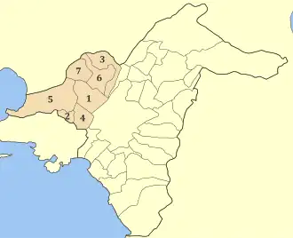 Municipalities of West Athens | |
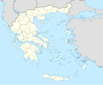 West Athens West Athens within Greece  | |
| Coordinates: 38°01′N 23°41′E / 38.017°N 23.683°E | |
| Country | Greece |
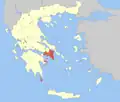
| Administrative region | Attica |
| Seat | Peristeri |
| Area | |
• Total | 66.7 km2 (25.8 sq mi) |
| Population (2021)[1] | |
• Total | 478,883 |
| • Density | 7,200/km2 (19,000/sq mi) |
| Time zone | UTC+2 (EET) |
| • Summer (DST) | UTC+3 (EEST) |
| Postal code | 12x xx, 13x xx |
| Area code(s) | 210 |
West Athens (Greek: Δυτικός Τομέας Αθηνών) is one of the regional units of Greece. It is part of the region of Attica. The regional unit covers the west-central part of the agglomeration of Athens.
Administration
As a part of the 2011 Kallikratis government reform, the regional unit West Athens was created out of part of the former Athens Prefecture. It is subdivided into 7 municipalities. These are (number as in the map in the infobox):[2]
- Agia Varvara (2)
- Agioi Anargyroi-Kamatero (3)
- Aigaleo (4)
- Chaidari (5)
- Ilion (6)
- Peristeri (1)
- Petroupoli (7)
See also
- List of settlements in Attica
References
- ↑ "Αποτελέσματα Απογραφής Πληθυσμού - Κατοικιών 2021, Μόνιμος Πληθυσμός κατά οικισμό" [Results of the 2021 Population - Housing Census, Permanent population by settlement] (in Greek). Hellenic Statistical Authority. 29 March 2024.
- ↑ "ΦΕΚ A 87/2010, Kallikratis reform law text" (in Greek). Government Gazette.
Administrative divisions of the Attica Region | ||
|---|---|---|
| ||
| Regional unit of Central Athens |
|  |
| Regional unit of North Athens |
| |
| Regional unit of West Athens | ||
| Regional unit of South Athens |
| |
| Regional unit of Piraeus |
| |
| Regional unit of East Attica |
| |
| Regional unit of West Attica |
| |
| Regional unit of Islands |
| |
| ||
This article is issued from Wikipedia. The text is licensed under Creative Commons - Attribution - Sharealike. Additional terms may apply for the media files.