Kech District
Kech District
ضلع کیچ کیچ دمگ | |
|---|---|
District | |
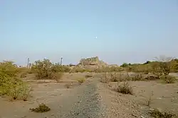  Katak Fort Bottom: Fields in Tejaban | |
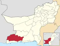 Map of Balochistan with Kech District highlighted in maroon | |
| Country | |
| Province | |
| Division | Makran |
| Headquarter | Turbat |
| Government | |
| • Type | District Administration |
| • Deputy Commissioner | N/A |
| • District Police Officer | N/A |
| • District Health Officer | N/A |
| Area | |
• Total | 22,539 km2 (8,702 sq mi) |
| Population (2023)[1] | |
• Total | 1,060,931 |
| • Density | 47/km2 (120/sq mi) |
| Literacy | |
| • Literacy rate |
|
| Time zone | UTC+5 (PST) |
| Number of Tehsils | 5 |
Kech District (Urdu: ضلع کیچ) is a district in the Balochistan province of Pakistan. This district's old name was Turbat District which was changed to its even older name Kech District in 1994-1995.[3]
Administration
The district of Kech is administratively subdivided into the following tehsils, each of which contains several villages:[4][5]
| Tehsil | Area
(km²)[6] |
Pop.
(2023) |
Density
(ppl/km²) (2023) |
Literacy rate
(2023)[7] |
Union Councils |
|---|---|---|---|---|---|
| Mand Tehsil | 1,456 | 56,772 | 38.99 | 54.19% | ... |
| Tump Tehsil | 1,945 | 147,041 | 75.60 | 47.17% | ... |
| Turbat Tehsil[5] | 9,742 | 470,605 | 48.31 | 63.65% | ... |
| Balnigor Tehsil | 1,238 | 50,404 | 40.71 | 38.77% | ... |
| Buleda Tehsil[5] | 1,997 | 107,847 | 54.00 | 35.36% | ... |
| Dasht Tehsil[5] | 2,486 | 90,080 | 36.23 | 37.25% | ... |
| Hoshab Tehsil | ... | ... | ... | 30.71% | ... |
| Zamuran Tehsil | 1,462 | 71,616 | 48.98 | 28.97% | ... |
| Gayab Tehsil | ... | ... | ... | ... | ... |
| Solband Tehsil | ... | ... | ... | ... | ... |
Demographics
| Year | Pop. | ±% p.a. |
|---|---|---|
| 1951 | N/A | — |
| 1961 | N/A | — |
| 1972 | N/A | — |
| 1981 | N/A | — |
| 1998 | 413,204 | — |
| 2017 | 907,182 | +4.23% |
| 2023 | 1,060,931 | +2.64% |
| Sources:[8] | ||
Population
As of the 2023 census, Kech district has 253,475 households and a population of 1,060,931. The district has a sex ratio of 109.82 males to 100 females and a literacy rate of 49.65%: 55.23% for males and 43.46% for females.[9][10] 328,574 (30.97% of the surveyed population) are under 10 years of age.[11] 386,646 (36.44%) live in urban areas.[9]
Religion
In the 2023 census, 0.41% (4,331) of the population was from religious minorities, mainly Christians.[12]
Language
Balochi was the predominant language, spoken by 99.73% of the population, with very small minorities of Brahui, Sindhi and Kashmiri speakers.[1]
See also
- Tehsils in Pakistan
- Tehsils of Balochistan
- Tehsils of Punjab, Pakistan
- Tehsils of Khyber Pakhtunkhwa
- Tehsils of Sindh, Pakistan
- Tehsils of Azad Kashmir
- Tehsils of Gilgit-Baltistan
- Districts of Pakistan
- Districts of Khyber Pakhtunkhwa
- Districts of Punjab, Pakistan
- Districts of Balochistan, Pakistan
- Districts of Sindh, Pakistan
- Districts of Azad Kashmir
- Districts of Gilgit-Baltistan
- Divisions of Pakistan
- Divisions of Balochistan
- Divisions of Khyber Pakhtunkhwa
- Divisions of Punjab, Pakistan
- Divisions of Sindh
- Divisions of Azad Kashmir
- Divisions of Gilgit-Baltistan
References
- 1 2 "Population by Mother Tongue, Sex and Rural/Urban, Census-2023" (PDF). Pakistan Bureau of Statistics.
- ↑ "Literacy rate, enrolments, and out-of-school population by sex and rural/urban, CENSUS-2023, BALOCHISTAN" (PDF).
- ↑ "Kech District background". Balochistan Police website. Archived from the original on 12 December 2008. Retrieved 6 February 2024.
- ↑ "Tehsils & Unions in the District of Kech/Turbat". National Reconstruction Bureau, Government of Pakistan. Archived from the original on 5 August 2012. Retrieved 27 March 2023.
- 1 2 3 4 "Zila, Tehsil & Town Councils Membership for Balochistan". National Reconstruction Bureau, Government of Pakistan. Archived from the original on 26 March 2012. Retrieved 27 March 2023.
- ↑ "TABLE 1 : AREA, POPULATION BY SEX, SEX RATIO, POPULATION DENSITY, URBAN POPULATION, HOUSEHOLD SIZE AND ANNUAL GROWTH RATE, CENSUS-2023, BALOCHISTAN" (PDF).
- ↑ "LITERACY RATE, ENROLMENT AND OUT OF SCHOOL POPULATION BY SEX AND RURAL/URBAN, CENSUS-2023, BALOCHISTAN" (PDF).
- ↑ "Population by administrative units 1951-1998" (PDF). Pakistan Bureau of Statistics.
- 1 2 "7th Population and Housing Census - Detailed Results: Table 1" (PDF). Pakistan Bureau of Statistics.
- ↑ "7th Population and Housing Census - Detailed Results: Table 12" (PDF). Pakistan Bureau of Statistics.
- ↑ "7th Population and Housing Census: Population by Mother Tongue, Sex and Rural/Urban" (PDF). Pakistan Bureau of Statistics.
- ↑ "Population by Sex, Religion and Rural/Urban, Census - 2023" (PDF). Pakistan Bureau of Statistics.
External links
26°00′N 63°00′E / 26.000°N 63.000°E
Districts of Balochistan, Pakistan | ||
|---|---|---|
Provincial capital: Quetta | ||
| Kalat |  | |
| Makran | ||
| Nasirabad |
| |
| Quetta | ||
| Sibi |
| |
| Zhob | ||
| Rakhshan | ||
| Loralai | ||
a - formerly part of Quetta Division; b - formerly part of Kalat Division; c - formerly part of Zhob Division ; d - abolished | ||