Tangir District
Tangir District
ضلع تانگیر | |
|---|---|
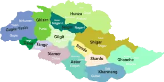 District map of Gilgit-Baltistan[b] | |
| Country | |
| Territory | |
| Division | Diamer Division |
| Headquarters | Tangir |
| Government | |
| • Type | District Administration |
| • Deputy Commissioner | N/A |
| • District Police Officer | N/A |
| • District Health Officer | N/A |
| Area (per UNOSAT)[1] | |
• Total | 1,106 km2 (427 sq mi) |
| Population (2023, per UNOSAT[1]) | |
• Total | 31,257 |
| • Density | 28/km2 (73/sq mi) |
| Languages | |
| • Official language | Urdu |
| Number of tehsils | 1 |
Tangir District (Urdu: ضلع تانگیر) is a district in the Gilgit-Baltistan region of Pakistan. It lies 67 km from Chilas.[2][3] Its population lives mainly in the valley of the Tangir River, a right tributary of the Indus River.[4]
History
Prior to 2019, the Tangir District was a tehsil of the Diamer District, along with Darel and Chilas.
Geography
The Tangir District is bounded on the north by the Gupis-Yasin District, on the north-east by the Ghizer District, on the east by the Darel District, and on the south and west by the Upper Kohistan District of Pakistan's Khyber Pakhtunkhwa Province.
Notes
- On the map, the Tangir District is incorrectly shown as Darel and vice versa.
- ↑ On the map, the Tangir District is incorrectly shown as Darel and vice versa.
References
- 1 2 "Satellite detected water extents between 26 and 30 July 2023 over Pakistan". United Nations Satellite Centre (UNOSAT). Retrieved April 6, 2025.
- ↑ "GB notifies four more districts, total number of districts now 14". pakistantoday.com.
- ↑ "Administrative Reforms: Gilgit-Baltistan govt issues notification of four new districts". pamirtimes.net.
- ↑ Tangir River, OpenStreetMap, retrieved 22 January 2022.
Capital: Gilgit | |
| Passes |
|
| Valleys |
|
| Cities and towns |
|
| Rivers, glaciers and lakes |
|
| Architecture |
|
| See also |
|
This article is issued from Wikipedia. The text is licensed under Creative Commons - Attribution - Sharealike. Additional terms may apply for the media files.