Shahriar County
Shahriar County
Persian: شهرستان شهریار | |
|---|---|
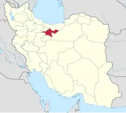
 Location of Shahriar County in Tehran province (center left, purple) | |
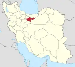
 Location of Tehran province in Iran | |
| Coordinates: 35°36′N 51°05′E / 35.600°N 51.083°E[1] | |
| Country | Iran |
| Province | Tehran |
| Capital | Shahriar |
| Districts | Central, Juqin |
| Area | |
• Total | 335.9 km2 (129.7 sq mi) |
| Population (2016)[2] | |
• Total | 744,210 |
| • Density | 2,200/km2 (5,700/sq mi) |
| Time zone | UTC+3:30 (IRST) |
Shahriar County (Persian: شهرستان شهریار) is in Tehran province, Iran. Its capital is the city of Shahriar.[3]
History
After the 2006 National Census, Malard and Qods Districts were separated from the county in the establishment of Malard and Qods Counties, respectively.[4]
After the 2016 census, Ferdows and Juqin Rural Districts, and the cities of Ferdowsiyeh and Vahidiyeh, were separated from the Central District in the formation of Juqin District.[5]
Demographics
Population
At the time of the 2006 census, the county's population was 1,044,707 in 273,826 households.[6] The following census in 2011 counted 624,440 people in 178,792 households.[7] The 2016 census measured the population of the county as 744,210 in 226,011 households.[2]
Administrative divisions
Shahriar County's population history and administrative structure over three consecutive censuses are shown in the following table.
| Administrative Divisions | 2006[6] | 2011[7] | 2016[2] |
|---|---|---|---|
| Central District | 516,022 | 624,440 | 744,206 |
| Ferdows RD | 15,225 | 8,041 | 12,003 |
| Juqin RD | 22,587 | 23,075 | 21,540 |
| Maviz RD | 6,199 | 6,291 | 5,782 |
| Qaemabad RD | 30,682 | 3,900 | 3,386 |
| Razakan RD | 25,395 | 26,420 | 26,004 |
| Saidabad RD | 16,176 | 17,671 | 18,903 |
| Andisheh (city) | 75,596 | 96,807 | 116,062 |
| Baghestan (city)[a] | 52,330 | 71,861 | 83,934 |
| Ferdowsiyeh (city) | 20,854 | 24,508 | 34,221 |
| Sabashahr (city)[b] | 18,132 | 47,123 | 53,971 |
| Shahedshahr (city)[c] | 18,855 | 20,865 | 25,544 |
| Shahriar (city) | 189,120 | 249,473 | 309,607 |
| Vahidiyeh (city) | 24,871 | 28,405 | 33,249 |
| Juqin District[d] | |||
| Ferdows RD | |||
| Juqin RD | |||
| Ferdowsiyeh (city)[e] | |||
| Vahidiyeh (city)[f] | |||
| Malard District[g] | 291,608 | ||
| Akhtarabad RD | 3,598 | ||
| Bibi Sakineh RD | 16,003 | ||
| Malard RD[h] | 27,479 | ||
| Malard (city) | 228,673 | ||
| Safadasht (city)[i] | 15,855 | ||
| Qods District[j] | 237,077 | ||
| Danesh RD | 4,799 | ||
| Haft Juy RD | 2,924 | ||
| Qods (city) | 229,354 | ||
| Total | 1,044,707 | 624,440 | 744,210 |
| RD = Rural District | |||
Climate
According to the information of the State Meteorological Organization of tehran province, the long-term average annual rainfall of Shahriar County is around 217.3 mm[14]
See also
![]() Media related to Shahriar County at Wikimedia Commons
Media related to Shahriar County at Wikimedia Commons
Notes
- ↑ Merger of several villages in 2004[8]
- ↑ Merger of several villages in 1996[9]
- ↑ Merger of several villages in 1997[10]
- ↑ Established after the 2016 census[5]
- ↑ Merger of several villages in 2000[11]
- ↑ Merger of several villages in 1996[12]
- ↑ Transferred to Malard County[4]
- ↑ Renamed Malard-e Shomali Rural District[4]
- ↑ Formerly Shahrabad[13]
- ↑ Transferred to Qods County[4]
References
- ↑ OpenStreetMap contributors (22 September 2024). "Shahriar County" (Map). OpenStreetMap (in Persian). Retrieved 22 September 2024.
- 1 2 3 Census of the Islamic Republic of Iran, 1395 (2016): Tehran Province. amar.org.ir (Report) (in Persian). The Statistical Center of Iran. Archived from the original (Excel) on 12 December 2021. Retrieved 19 December 2022.
- ↑ Habibi, Hassan (10 December 2014) [Approved 21 June 1369]. Approval of the organization and chain of citizenship of the elements and units of the national divisions of Tehran province centered on the city of Tehran. rc.majlis.ir (Report) (in Persian). Ministry of the Interior, Defense Political Commission of the Government Board. Notification 8416/T133K. Archived from the original on 30 November 2014. Retrieved 16 December 2023 – via Islamic Parliament Research Center.
- 1 2 3 4 Davodi, Parviz (22 April 2009). "The government's agreement with 18 changes in national divisions: Three counties were added to the geographical map of the country". dolat.ir (in Persian). Ministry of the Interior, Board of Ministers. Archived from the original on 5 February 2018. Retrieved 22 November 2023 – via Secretariat of the Government Information Council.
- 1 2 Jahangiri, Ishaq (9 December 2017) [Approved 13 August 2017]. Approval letter regarding the creation of Juqin District in the citizenship of Shahriar County of Tehran province. rc.majlis.ir (Report) (in Persian). Ministry of Interior, Council of Ministers. Notification 109667/T55045H. Archived from the original on 30 November 2018. Retrieved 24 December 2023 – via Islamic Parliament Research Center of the Islamic Republic of Iran.
- 1 2 Census of the Islamic Republic of Iran, 1385 (2006): Tehran Province. amar.org.ir (Report) (in Persian). The Statistical Center of Iran. Archived from the original (Excel) on 20 September 2011. Retrieved 25 September 2022.
- 1 2 Census of the Islamic Republic of Iran, 1390 (2011): Tehran Province. irandataportal.syr.edu (Report) (in Persian). The Statistical Center of Iran. Archived from the original (Excel) on 20 January 2023. Retrieved 19 December 2022 – via Iran Data Portal, Syracuse University.
- ↑ "Historical background of Baghestan city". baghestan.ir (in Persian). 14 December 2017. Archived from the original on 4 December 2018. Retrieved 23 September 2024 – via Baghestan Municipality.
- ↑ Habibi, Hassan (c. 2024) [Approved 6 July 1375]. The action of several villages in the Central District of Shahriar County and their transformation into Sabashahr. lamtakam.com (Report) (in Persian). Ministry of the Interior, Political-Defense Commission of the Government Board. Proposal 1.4.42.3523; Notification 7038/T16867K. Archived from the original on 23 September 2024. Retrieved 23 September 2024 – via Lam ta Kam.
- ↑ Habibi, Hassan (c. 2024) [Approved 17 April 1376]. Converting the village of Aliabad-Darazeh-Shahesvari from the Central District of Shahriar County to Shahedshahr. lamtakam.com (Report) (in Persian). Ministry of the Interior, Political-Defense Commission of the Government Board. Proposal 1.4.42.14646; Notification 54564/17935K. Archived from the original on 23 September 2024. Retrieved 23 September 2024 – via Lam ta Kam.
- ↑ Habibi, Hassan (c. 2024) [Approved 20 June 1379]. Merging several villages in Tehran province and turning them into Ferdowsiyeh city. lamtakam.com (Report) (in Persian). Ministry of the Interior, Political-Defense Commission of the Government Board. Proposal 1.4.42.13525. Archived from the original on 23 September 2024. Retrieved 23 September 2024 – via Lam ta Kam.
- ↑ Habibi, Hassan (30 August 1392) [Approved 20 March 1375]. Converting the villages of Juqin, Qasabeh, Qastanak, and Esmailabadbad from the Central District of Shahriar County in Tehran province to the city of Vahidiyeh. rc.majlis.ir (Report) (in Persian). Ministry of the Interior, Political-Defense Commission of the Government Board. Proposal 1.42.8571; Notification 2873/T15806K. Archived from the original on 21 November 2013. Retrieved 22 September 2024 – via Research Center of the System of Laws of the Islamic Council of the Farabi Library of Mobile Users.
- ↑ Habibi, Hassan (c. 2024) [Approved 28 February 1377]. The integration of the villages of Shahrabad, Hesar-e Tahmasab, Abadiyeh, and Nasirabad under Bibi Sakineh Rural District of the Central District of Shahriar County in Tehran province and their transformation into the city of Safadasht. lamtakam.com (Report) (in Persian). Ministry of the Interior, Council of Ministers. Proposal 1.4.42.10851; Notification 16980/19177AH. Archived from the original on 20 September 2024. Retrieved 20 September 2024 – via Lam ta Kam.
- ↑ Unknown
Tehran province, Iran | ||||||||||||||||||||||||||||||||||
|---|---|---|---|---|---|---|---|---|---|---|---|---|---|---|---|---|---|---|---|---|---|---|---|---|---|---|---|---|---|---|---|---|---|---|
| Capital |
| |||||||||||||||||||||||||||||||||
| Counties and cities |
| |||||||||||||||||||||||||||||||||
| Landmarks |
| |||||||||||||||||||||||||||||||||
| Populated places |
| |||||||||||||||||||||||||||||||||
^* indicates that this formerly independent city is now absorbed into Tehran. | ||||||||||||||||||||||||||||||||||