Santa Elena Province
Santa Elena | |
|---|---|
Province | |
| Province of Santa Elena | |
 Punta Carnero beach at the Pacific coast in Santa Elena Province | |
 Flag | |
.svg.png) Location of Santa Elena Province in Ecuador | |
 Cantons of Santa Elena Province | |
| Country | Ecuador |
| Established | November 7, 2007 |
| Named after | Santa Elena |
| Capital | Santa Elena |
| Cantons | List of Cantons
|
| Government | |
| • Provincial Prefect | José Daniel Villao |
| Area | |
• Total | 3,691 km2 (1,425 sq mi) |
| Population (2022 census)[1] | |
• Total | 385,735 |
| • Density | 100/km2 (270/sq mi) |
| Time zone | UTC-5 (ECT) |
| Area code | (0)4 |
| Vehicle registration | Y |
| HDI (2017) | 0.712[2] high · 20th |
| Website | www |
The Province of Santa Elena (Spanish pronunciation: [ˌsanta eˈlena]) is a province of Ecuador in the coastal region. Created in 2007 from territory that belonged to the Guayas Province, it is one of the two newest provinces of Ecuador, along with Santo Domingo de Los Tsáchilas. Its capital city is Santa Elena, from which the province derives its name.[3]
Political division
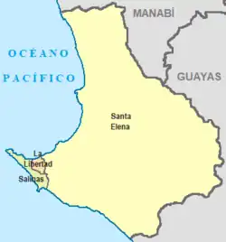
The province is divided into three cantons. The following table lists each with its population at the 2001 census, its area in square kilometres (km2), and the name of the canton seat or capital.[4]
| Canton | Pop. (2001) | Area (km2) | Seat/Capital |
|---|---|---|---|
| La Libertad | 115,950 | 25 | La Libertad |
| Salinas | 92,020 | 69 | Salinas |
| Santa Elena | 184,640 | 3,669 | Santa Elena |
Demographics
Ethnic groups as of the Ecuadorian census of 2010:[5]
- Mestizo 79.1%
- Afro-Ecuadorian 8.5%
- Montubio 4.9%
- White 3.7%
- Indigenous 1.4%
- Other 2.4%
See also
- Provinces of Ecuador
- Cantons of Ecuador
References
- ↑ Citypopulation.de Population and area of Santa Elena Province
- ↑ Villalba, Juan. "Human Development Index in Ecuador". Scribd (in Spanish). Retrieved 2019-02-05.
- ↑ "Santa Elena". www.explored.com.ec. Archived from the original on 21 January 2017. Retrieved 14 April 2018.
- ↑ Cantons of Ecuador. Statoids.com. Retrieved 4 November 2009.
- ↑ Censos, Instituto Nacional de Estadística y. "Resultados -" (PDF). www.ecuadorencifras.gob.ec. Retrieved 9 March 2024.
| Province |
|
|---|---|
| Former Provinces |
|
2°13′36″S 80°51′30″W / 2.2267°S 80.8583°W
This article is issued from Wikipedia. The text is licensed under Creative Commons - Attribution - Sharealike. Additional terms may apply for the media files.