Nahavand County
Nahavand County
Persian: شهرستان نهاوند | |
|---|---|
 | |
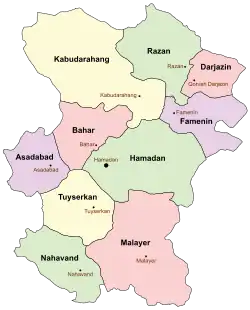 Location of Nahavand County in Hamadan province (bottom, green) | |
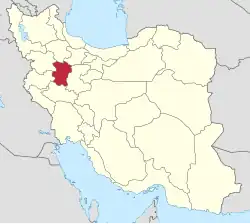
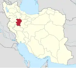 Location of Hamadan province in Iran | |
| Coordinates: 34°13′N 48°13′E / 34.217°N 48.217°E[1] | |
| Country | Iran |
| Province | Hamadan |
| Capital | Nahavand |
| Districts | Central, Giyan, Khezel, Zarrin Dasht |
| Population (2016)[2] | |
• Total | 178,787 |
| Time zone | UTC+3:30 (IRST) |
| Nahavand County can be found at GEOnet Names Server, at this link, by opening the Advanced Search box, entering "9207369" in the "Unique Feature Id" form, and clicking on "Search Database". | |
Nahavand County (Persian: شهرستان نهاوند) is in Hamadan province, Iran. Its capital is the city of Nahavand.[3]
Demographics
Population
At the time of the 2006 National Census, the county's population was 178,683 in 46,283 households.[4] The following census in 2011 counted 181,711 people in 53,821 households.[5] The 2016 census measured the population of the county as 178,787 in 55,542 households.[2]
Administrative divisions
Nahavand County's population history and administrative structure over three consecutive censuses are shown in the following table.
| Administrative Divisions | 2006[4] | 2011[5] | 2016[2] |
|---|---|---|---|
| Central District | 116,092 | 119,191 | 117,270 |
| Gamasiyab RD | 14,597 | 14,983 | 13,616 |
| Shaban RD | 15,321 | 15,250 | 14,321 |
| Tariq ol Eslam RD | 13,956 | 13,513 | 13,171 |
| Nahavand (city) | 72,218 | 75,445 | 76,162 |
| Giyan District | 17,253 | 17,811 | 17,027 |
| Giyan RD | 2,705 | 3,038 | 2,863 |
| Sarab RD | 6,486 | 6,671 | 5,978 |
| Giyan (city) | 8,062 | 8,102 | 8,186 |
| Khezel District | 30,903 | 30,081 | 29,968 |
| Khezel-e Sharqi RD | 12,926 | 11,706 | 11,538 |
| Solgi RD | 13,923 | 13,740 | 13,257 |
| Firuzan (city) | 4,054 | 4,635 | 5,173 |
| Zarrin Dasht District | 14,435 | 14,112 | 13,046 |
| Fazl RD | 4,268 | 4,042 | 3,731 |
| Garin RD | 7,438 | 7,375 | 6,858 |
| Barzul (city) | 2,729 | 2,695 | 2,457 |
| Total | 178,683 | 181,711 | 178,787 |
| RD = Rural District | |||
See also
![]() Media related to Nahavand County at Wikimedia Commons
Media related to Nahavand County at Wikimedia Commons
References
- ↑ OpenStreetMap contributors (15 November 2024). "Nahavand County" (Map). OpenStreetMap (in Persian). Retrieved 15 November 2024.
- 1 2 3 Census of the Islamic Republic of Iran, 1395 (2016): Hamadan Province. amar.org.ir (Report) (in Persian). The Statistical Center of Iran. Archived from the original (Excel) on 21 April 2021. Retrieved 19 December 2022.
- ↑ Habibi, Hassan (c. 2024) [Approved 21 June 1369]. Approval of the organization and chain of citizenship of the elements and units of the national divisions of Hamadan province, centered in Hamadan city. lamtakam.com (Report) (in Persian). Ministry of the Interior, Political Defense Commission of the Government Board. Proposal 3233.1.5.53; Letter 93808-907; Notification 82834/T134K. Archived from the original on 11 February 2024. Retrieved 11 February 2024.
- 1 2 Census of the Islamic Republic of Iran, 1385 (2006): Hamadan Province. amar.org.ir (Report) (in Persian). The Statistical Center of Iran. Archived from the original (Excel) on 20 September 2011. Retrieved 25 September 2022.
- 1 2 Census of the Islamic Republic of Iran, 1390 (2011): Hamadan Province. irandataportal.syr.edu (Report) (in Persian). The Statistical Center of Iran. Archived from the original (Excel) on 17 January 2023. Retrieved 19 December 2022 – via Iran Data Portal, Syracuse University.
Hamadan province, Iran | |||||||||||||||||||||
|---|---|---|---|---|---|---|---|---|---|---|---|---|---|---|---|---|---|---|---|---|---|
| Capital |
|  | |||||||||||||||||||
| Counties and cities |
| ||||||||||||||||||||
| Sights |
| ||||||||||||||||||||
| populated places |
| ||||||||||||||||||||
This article is issued from Wikipedia. The text is licensed under Creative Commons - Attribution - Sharealike. Additional terms may apply for the media files.