Masjed Soleyman County
Masjed Soleyman County
Persian: شهرستان مسجد سلیمان | |
|---|---|
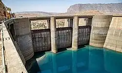 Shahid Abbaspour Dam | |
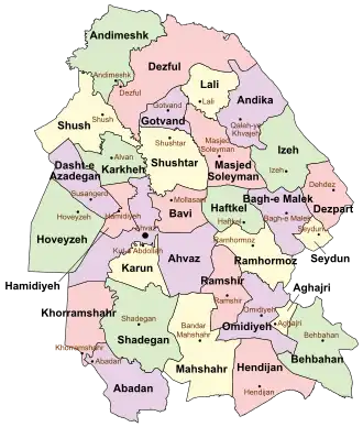 Location of Masjed Soleyman County in Khuzestan province (center right, pink) | |
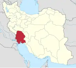 Location of Khuzestan province in Iran | |
| Coordinates: 32°01′N 49°21′E / 32.017°N 49.350°E[1] | |
| Country | Iran |
| Province | Khuzestan |
| Capital | Masjed Soleyman |
| Districts | Central, Anbar, Golgir |
| Population (2016)[2] | |
• Total | 113,419 |
| Time zone | UTC+3:30 (IRST) |
Masjed Soleyman County (Persian: شهرستان مسجد سلیمان) is in Khuzestan province, Iran. Its capital is the city of Masjed Soleyman.[3]
History
After the 2006 National Census, Andika District was separated from the county in the establishment of Andika County. At the same time, Jahangiri-ye Shomali Rural District was created in the Central District, and Tembi Golgir and Tolbozan Rural Districts were separated from it in the formation of Golgir District.[4]
After the 2011 census, villages were separated from the Central District to form Anbar District, which was divided into the new Anbar and Zeylabi Rural Districts. The village of Golgir was elevated to the status of a city as well.[5]
Demographics
Population
At the time of the 2006 census, the county's population was 167,226 in 33,484 households.[6] The following census in 2011 counted 113,257 people in 26,804 households.[7] The 2016 census measured the population of the county as 113,419 in 30,115 households.[2]
Administrative divisions
Masjed Soleyman County's population history and administrative structure over three consecutive censuses are shown in the following table.
| Administrative Divisions | 2006[6] | 2011[7] | 2016[2] |
|---|---|---|---|
| Central District | 117,796 | 106,991 | 104,059 |
| Jahangiri RD | 3,981 | 2,122 | 2,469 |
| Jahangiri-ye Shomali RD | 1,500 | 1,093 | |
| Tembi Golgir RD | 4,619 | ||
| Tolbozan RD | 3,075 | ||
| Masjed Soleyman (city) | 106,121 | 103,369 | 100,497 |
| Anbar District | 2,045 | ||
| Anbar RD | 1,262 | ||
| Zeylabi RD | 783 | ||
| Andika District[a] | 49,430 | ||
| Abezhdan RD | 13,493 | ||
| Chelu RD | 5,118 | ||
| Kushk RD | 8,479 | ||
| Lalar and Katak RD | 3,991 | ||
| Qaleh-ye Khvajeh RD | 13,094 | ||
| Shalal and Dasht-e Gol RD | 4,454 | ||
| Qaleh-ye Khvajeh (city) | 801 | ||
| Golgir District | 5,527 | 7,238 | |
| Tembi Golgir RD | 3,672 | 3,664 | |
| Tolbozan RD | 1,855 | 2,485 | |
| Golgir (city) | 1,089 | ||
| Total | 167,226 | 113,257 | 113,419 |
| RD = Rural District | |||
See also
![]() Media related to Masjed Soleyman County at Wikimedia Commons
Media related to Masjed Soleyman County at Wikimedia Commons
Notes
- ↑ Transferred to Andika County[4]
References
- ↑ OpenStreetMap contributors (21 December 2024). "Masjed Soleyman County" (Map). OpenStreetMap (in Persian). Retrieved 21 December 2024.
- 1 2 3 Census of the Islamic Republic of Iran, 1395 (2016): Khuzestan Province. amar.org.ir (Report) (in Persian). The Statistical Center of Iran. Archived from the original (Excel) on 21 October 2020. Retrieved 19 December 2022.
- ↑ Habibi, Hassan (26 July 2014) [Approved 21 June 1369]. Approval of the organization and chain of citizenship of the elements and units of the national divisions of Khuzestan province, centered in the city of Ahvaz. rc.majlis.ir (Report) (in Persian). Ministry of the Interior, Political and Defense Commission of the Government Board. Proposal 3233.1.5.53; Letter 907-93808; Notification 82830/T126K. Archived from the original on 17 July 2014. Retrieved 25 January 2024 – via Islamic Parliament Research Center.
- 1 2 Davodi, Parviz (c. 2023) [Approved 29 July 1386]. Approval letter regarding the reforms of national divisions in Khuzestan province, Masjed Soleyman County. dastour.ir (Report) (in Persian). Ministry of the Interior, Political and Defense Commission. Proposal 44245/42/1/4/1; Letter 58538/T26118H. Archived from the original on 5 November 2023. Retrieved 5 November 2023.
- ↑ Rahimi, Mohammadreza (15 January 2013) [Approved 19 July 1391]. Approval letter regarding national divisions in Khuzestan province (PDF). rrk.ir (Report) (in Persian). Ministry of the Interior, Political and Defense Commission. Resolution 158802/T38854AH; Notification 205939/T45312H. Archived from the original (PDF) on 4 November 2023. Retrieved 4 November 2023.
- 1 2 Census of the Islamic Republic of Iran, 1385 (2006): Khuzestan Province. amar.org.ir (Report) (in Persian). The Statistical Center of Iran. Archived from the original (Excel) on 20 September 2011. Retrieved 25 September 2022.
- 1 2 Census of the Islamic Republic of Iran, 1390 (2011): Khuzestan Province. irandataportal.syr.edu (Report) (in Persian). The Statistical Center of Iran. Archived from the original (Excel) on 18 January 2023. Retrieved 19 December 2022 – via Iran Data Portal, Syracuse University.
Khuzestan province, Iran | |||||||||||||||||||||||||||||||||||||||||||||||||||||
|---|---|---|---|---|---|---|---|---|---|---|---|---|---|---|---|---|---|---|---|---|---|---|---|---|---|---|---|---|---|---|---|---|---|---|---|---|---|---|---|---|---|---|---|---|---|---|---|---|---|---|---|---|---|
| Capital |  | ||||||||||||||||||||||||||||||||||||||||||||||||||||
| Counties and cities |
| ||||||||||||||||||||||||||||||||||||||||||||||||||||
| Sights |
| ||||||||||||||||||||||||||||||||||||||||||||||||||||
| Populated places |
| ||||||||||||||||||||||||||||||||||||||||||||||||||||
| Capital |
| ||||||||||||||||||
|---|---|---|---|---|---|---|---|---|---|---|---|---|---|---|---|---|---|---|---|
| Districts |
| ||||||||||||||||||