Mahabad County
Mahabad County
Persian: شهرستان مهاباد | |
|---|---|
| Nickname: سابلاغ | |
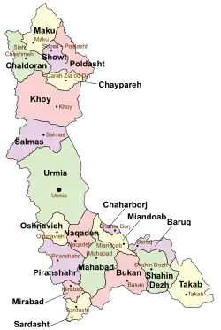 Location of Mahabad County in West Azerbaijan province (bottom center, green) | |
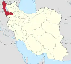 Location of West Azerbaijan province in Iran | |
| Coordinates: 36°39′N 45°42′E / 36.650°N 45.700°E[1] | |
| Country | Iran |
| Province | West Azerbaijan |
| Capital | Mahabad |
| Districts | Central, Khalifan |
| Area | |
• Total | 2,591 km2 (1,000 sq mi) |
| Population (2016)[2] | |
• Total | 236,849 |
| • Density | 91/km2 (240/sq mi) |
| Time zone | UTC+3:30 (IRST) |
| Mahabad County can be found at GEOnet Names Server, at this link, by opening the Advanced Search box, entering "9205914" in the "Unique Feature Id" form, and clicking on "Search Database". | |
Mahabad County (Persian: شهرستان مهاباد) is in West Azerbaijan province, Iran. Its capital is the city of Mahabad.[3]
History
After the 2006 National Census, the village of Khalifan was elevated to the status of a city.[4]
Demographics
Population
At the time of the 2006 census, the county's population was 197,441 in 42,493 households.[5] The following census in 2011 counted 215,529 people in 53,563 households.[6] The 2016 census measured the population of the county as 236,849 in 65,562 households.[2]
Administrative divisions
Mahabad County's population history and administrative structure over three consecutive censuses are shown in the following table.
| Administrative Divisions | 2006[5] | 2011[6] | 2016[2] |
|---|---|---|---|
| Central District | 179,697 | 198,757 | 222,069 |
| Akhtachi-ye Gharbi RD | 7,899 | 7,455 | 7,412 |
| Mokriyan-e Gharbi RD | 25,643 | 28,877 | 30,719 |
| Mokriyan-e Sharqi RD | 12,831 | 15,157 | 15,545 |
| Mahabad (city) | 133,324 | 147,268 | 168,393 |
| Khalifan District | 17,744 | 16,772 | 14,780 |
| Kani Bazar RD | 10,199 | 8,910 | 7,801 |
| Mangur-e Sharqi RD | 7,545 | 6,900 | 6,230 |
| Khalifan (city) | 962 | 749 | |
| Total | 197,441 | 215,529 | 236,849 |
| RD = Rural District | |||
Geography
The climate is mountainous with cold winters and temperate summers. Mahabad river flows through the capital.
See also
![]() Media related to Mahabad County at Wikimedia Commons
Media related to Mahabad County at Wikimedia Commons
References
- ↑ OpenStreetMap contributors (25 September 2024). "Mahabad County" (Map). OpenStreetMap (in Persian). Retrieved 25 September 2024.
- 1 2 3 Census of the Islamic Republic of Iran, 1395 (2016): West Azerbaijan Province. amar.org.ir (Report) (in Persian). The Statistical Center of Iran. Archived from the original (Excel) on 30 August 2022. Retrieved 19 December 2022.
- ↑ Habibi, Hassan (c. 2023) [Approved 21 June 1369]. Approval of the organization and chain of citizenship of the elements and units of the national divisions of West Azerbaijan province, centered in the city of Urmia. lamtakam.com (Report) (in Persian). Ministry of the Interior, Defense Political Commission of the Government Council. Notification 82808/T137. Archived from the original on 20 December 2023. Retrieved 20 December 2023 – via Lam ta Kam.
- ↑ Rahimi, Mohammad Reza (c. 2023) [Approved 25 October 1389]. Approval letter regarding the conversion of Khalifan village, the center of Khalifan District, from the functions of Mahabad County in West Azerbaijan province, to a city. lamtakam.com (Report) (in Persian). Ministry of the Interior, Political-Defense Commission. Proposal 169226/42/1/4/1; Notification 241082/T42116K. Archived from the original on 25 September 2024. Retrieved 25 September 2024 – via Lam ta Kam.
- 1 2 Census of the Islamic Republic of Iran, 1385 (2006): West Azerbaijan Province. amar.org.ir (Report) (in Persian). The Statistical Center of Iran. Archived from the original (Excel) on 20 September 2011. Retrieved 25 September 2022.
- 1 2 Census of the Islamic Republic of Iran, 1390 (2011): West Azerbaijan Province. irandataportal.syr.edu (Report) (in Persian). The Statistical Center of Iran. Archived from the original (Excel) on 20 January 2023. Retrieved 19 December 2022 – via Iran Data Portal, Syracuse University.
West Azerbaijan province, Iran | ||
|---|---|---|
List of cities, towns and villages in West Azerbaijan Province | ||
| Capital |
|  |
| Counties and cities |
| |
| Tourism |
| |
| Places | List of cities, towns and villages in West Azerbaijan Province | |