List of mountain peaks of Oregon
This article comprises three sortable tables of major mountain peaks[1] of the U.S. State of Oregon.
The summit of a mountain or hill may be measured in three principal ways:
- The topographic elevation of a summit measures the height of the summit above a geodetic sea level.[2][3] The first table below ranks the 30 highest major summits of Oregon by elevation.
- The topographic prominence of a summit is a measure of how high the summit rises above its surroundings.[4][3] The second table below ranks the 30 most prominent summits of Oregon.
- The topographic isolation (or radius of dominance) of a summit measures how far the summit lies from its nearest point of equal elevation.[5] The third table below ranks the 30 most isolated major summits of Oregon.
Highest major summits
Of the highest major summits of Oregon, five peaks exceed 3000 meters (9843 feet) elevation and 28 peaks exceed 2500 meters (8202 feet) elevation.
| Rank | Mountain peak | Mountain range | Elevation | Prominence | Isolation | Location |
|---|---|---|---|---|---|---|
| 1 | Mount Hood[6][7][8][9][a] | Cascade Range | 11,249 ft 3428.8 m | 7,706 ft 2349 m | 57.3 mi 92.2 km |
45°22′25″N 121°41′45″W / 45.3735°N 121.6959°W |
| 2 | Mount Jefferson[10][11][12][13][b] | Cascade Range | 10,502 ft 3201 m | 5,797 ft 1767 m | 48.1 mi 77.5 km |
44°40′27″N 121°47′59″W / 44.6743°N 121.7996°W |
| 3 | South Sister[14][15][16][17] | Cascade Range | 10,363 ft 3158.5 m | 5,593 ft 1705 m | 39.4 mi 63.4 km |
44°06′13″N 121°46′09″W / 44.1035°N 121.7693°W |
| 4 | North Sister[18][19][20][21][c] | Cascade Range | 10,090 ft 3075 m | 2,745 ft 837 m | 4.35 mi 7 km |
44°10′00″N 121°46′20″W / 44.1666°N 121.7723°W |
| 5 | Middle Sister[22][23][24][25][d] | Cascade Range | 10,052 ft 3064 m | 1,252 ft 382 m | 1.12 mi 1.8 km |
44°08′54″N 121°47′02″W / 44.1483°N 121.7840°W |
| 6 | Sacajawea Peak[26][27][28][e][f] | Wallowa Mountains | 9,843 ft 3000 m | 6,393 ft 1949 m | 125.5 mi 202 km |
45°14′42″N 117°17′34″W / 45.2450°N 117.2929°W |
| 7 | Steens Mountain[29][30][31][g] | Steens Mountain | 9,738 ft 2968 m | 4,383 ft 1336 m | 124.7 mi 201 km |
42°38′11″N 118°34′36″W / 42.6364°N 118.5767°W |
| 8 | Aneroid Mountain[32][33][34][35] | Wallowa Mountains | 9,707 ft 2958.7 m | 2,122 ft 647 m | 5.89 mi 9.48 km |
45°12′11″N 117°10′30″W / 45.2030°N 117.1750°W |
| 9 | Twin Peaks[36][37][38][h] | Wallowa Mountains | 9,678 ft 2950 m | 2,003 ft 610 m | 4.84 mi 7.79 km |
45°18′17″N 117°20′43″W / 45.3046°N 117.3452°W |
| 10 | Eagle Cap[39][40] | Wallowa Mountains | 9,577 ft 2919 m | 1,211 ft 369 m | 2.68 mi 4.32 km |
45°09′49″N 117°18′06″W / 45.163695°N 117.301622°W |
| 11 | Red Mountain[41][42][43][44] | Wallowa Mountains | 9,560 ft 2913.8 m | 2,000 ft 610 m | 7.36 mi 11.84 km |
45°03′52″N 117°14′46″W / 45.0644°N 117.2460°W |
| 12 | Mount McLoughlin[45][46][47][48][i][j] | Cascade Range | 9,499 ft 2895 m | 4,475 ft 1364 m | 69.5 mi 111.8 km |
42°26′40″N 122°18′56″W / 42.4445°N 122.3156°W |
| 13 | Elkhorn Peak[49][50][51][k] | Wallowa Mountains | 9,238 ft 2816 m | 1,860 ft 567 m | 3.31 mi 5.32 km |
45°13′20″N 117°23′48″W / 45.2223°N 117.3968°W |
| 14 | Mount Thielsen[52][53][54][55] | Cascade Range | 9,184 ft 2799.4 m | 3,362 ft 1025 m | 50.4 mi 81.1 km |
43°09′10″N 122°03′59″W / 43.1528°N 122.0665°W |
| 15 | Broken Top[56][57][58][l] | Cascade Range | 9,180 ft 2798 m | 2,195 ft 669 m | 3.43 mi 5.52 km |
44°04′59″N 121°41′58″W / 44.0830°N 121.6994°W |
| 16 | Rock Creek Butte[59][60][61][m] | Elkhorn Mountains | 9,111 ft 2777 m | 4,476 ft 1364 m | 43.4 mi 69.9 km |
44°49′00″N 118°06′14″W / 44.8168°N 118.1039°W |
| 17 | Krag Peak[62][63] | Wallowa Mountains | 9,078 ft 2767 m | 1,240 ft 378 m | 1.32 mi 2.12 km |
45°03′55″N 117°17′21″W / 45.0652516°N 117.2892716°W |
| 18 | Mount Bachelor[64][65][66][67] | Cascade Range | 9,068 ft 2764 m | 2,685 ft 818 m | 6.85 mi 11.02 km |
43°58′46″N 121°41′19″W / 43.9794°N 121.6885°W |
| 19 | Strawberry Mountain[68][69][70][71][n] | Strawberry Range | 9,042 ft 2756.1 m | 4,110 ft 1253 m | 46.1 mi 74.2 km |
44°18′44″N 118°43′00″W / 44.3123°N 118.7166°W |
| 20 | Needle Point[72][73] | Wallowa Mountains | 9,022 ft 2750 m | 1,460 ft 445 m | 2.04 mi 3.29 km |
45°07′39″N 117°21′08″W / 45.127418°N 117.352214°W |
| 21 | Mount Scott[74][75][76][77] | Cascade Range | 8,933 ft 2722.9 m | 3,019 ft 920 m | 16.07 mi 25.9 km |
42°55′22″N 122°00′58″W / 42.9229°N 122.0162°W |
| 22 | Diamond Peak[78][79][80][81] | Cascade Range | 8,748 ft 2666.4 m | 3,124 ft 952 m | 25.7 mi 41.4 km |
43°31′15″N 122°08′59″W / 43.5207°N 122.1496°W |
| 23 | Pueblo Mountain[82][83][84][85][o] | Pueblo Mountains | 8,639 ft 2633.3 m | 3,042 ft 927 m | 28.3 mi 45.5 km |
42°05′58″N 118°39′02″W / 42.0995°N 118.6506°W |
| 24 | Crane Mountain[86][87][88][89] | Warner Mountains | 8,451 ft 2575.8 m | 2,356 ft 718 m | 44.4 mi 71.4 km |
42°03′46″N 120°14′27″W / 42.0628°N 120.2408°W |
| 25 | Drake Peak[90][91][92][93][p] | Warner Mountains | 8,411 ft 2564 m | 2,557 ft 779 m | 17.44 mi 28.1 km |
42°18′00″N 120°07′26″W / 42.3001°N 120.1238°W |
| 26 | Mount Bailey[94][95][96][97][q] | Cascade Range | 8,377 ft 2553.3 m | 2,978 ft 908 m | 7.76 mi 12.49 km |
43°09′18″N 122°13′12″W / 43.1551°N 122.2200°W |
| 27 | Gearhart Mountain[98][99][100][101] | Gearhart Mountain | 8,368 ft 2550.6 m | 3,440 ft 1049 m | 40.8 mi 65.7 km |
42°29′46″N 120°52′38″W / 42.4960°N 120.8773°W |
| 28 | Aspen Butte[102][103][104][105] | Cascade Range | 8,215 ft 2503.83 m | 3,108 ft 947 m | 14.7 mi 23.7 km |
42°18′56″N 122°05′15″W / 42.3155°N 122.0876°W |
| 29 | Yamsay Mountain[106][107][108][109] | Cascade Volcanic Arc | 8,200 ft 2499.3 m | 3,181 ft 970 m | 33 mi 53.1 km |
42°55′50″N 121°21′39″W / 42.9306°N 121.3607°W |
| 30 | Vinegar Hill[110][111][112][113][r] | Greenhorn Mountains | 8,144 ft 2482 m | 2,900 ft 884 m | 14.58 mi 23.5 km |
44°42′50″N 118°33′42″W / 44.7138°N 118.5617°W |
| 31 | Pelican Butte[114][115][116][117] | Cascade Range | 8,037 ft 2449.8 m | 2,196 ft 669 m | 9.93 mi 15.98 km |
42°30′48″N 122°08′43″W / 42.5134°N 122.1453°W |
| 32 | Lookout Mountain[118][119][120][s] | Strawberry Range | 8,037 ft 2450 m | 2,132 ft 650 m | 6.67 mi 10.73 km |
44°17′20″N 118°29′43″W / 44.2889°N 118.4954°W |
| 33 | Warner Peak[121][122][123][124][t] | Hart Mountain | 8,024 ft 2445.8 m | 2,127 ft 648 m | 22.1 mi 35.6 km |
42°27′35″N 119°44′29″W / 42.4597°N 119.7414°W |
| 34 | Paulina Peak[125][126][127][128][u] | Paulina Mountains | 7,989 ft 2435 m | 3,219 ft 981 m | 28.9 mi 46.5 km |
43°41′21″N 121°15′18″W / 43.6892°N 121.2549°W |
Most prominent summits
Of the most prominent summits of Oregon, Mount Hood exceeds 2000 meters (6562 feet) of topographic prominence. Four peaks are ultra-prominent summits with more than 1500 meters (4921 feet) of topographic prominence and 12 peaks exceed 1000 meters (3281 feet) of topographic prominence.
| Rank | Mountain peak | Mountain range | Elevation | Prominence | Isolation | Location |
|---|---|---|---|---|---|---|
| 1 | Mount Hood[6][7][8][9][a] | Cascade Range | 11,249 ft 3428.8 m | 7,706 ft 2349 m | 57.3 mi 92.2 km |
45°22′25″N 121°41′45″W / 45.3735°N 121.6959°W |
| 2 | Sacajawea Peak[26][27][28][e][f] | Wallowa Mountains | 9,843 ft 3000 m | 6,393 ft 1949 m | 125.5 mi 202 km |
45°14′42″N 117°17′34″W / 45.2450°N 117.2929°W |
| 3 | Mount Jefferson[10][11][12][13][b] | Cascade Range | 10,502 ft 3201 m | 5,797 ft 1767 m | 48.1 mi 77.5 km |
44°40′27″N 121°47′59″W / 44.6743°N 121.7996°W |
| 4 | South Sister[129][130][131][132] | Cascade Range | 10,363 ft 3158.5 m | 5,593 ft 1705 m | 39.4 mi 63.4 km |
44°06′13″N 121°46′09″W / 44.1035°N 121.7693°W |
| 5 | Rock Creek Butte[59][60][61][v][m] | Elkhorn Mountains | 9,111 ft 2777 m | 4,476 ft 1364 m | 43.4 mi 69.9 km |
44°49′00″N 118°06′14″W / 44.8168°N 118.1039°W |
| 6 | Mount McLoughlin[45][46][47][48][i][j] | Cascade Range | 9,499 ft 2895 m | 4,475 ft 1364 m | 69.5 mi 111.8 km |
42°26′40″N 122°18′56″W / 42.4445°N 122.3156°W |
| 7 | Steens Mountain[29][30][31][g] | Steens Mountain | 9,738 ft 2968 m | 4,383 ft 1336 m | 124.7 mi 201 km |
42°38′11″N 118°34′36″W / 42.6364°N 118.5767°W |
| 8 | Strawberry Mountain[68][69][70][71][n] | Strawberry Range | 9,042 ft 2756.1 m | 4,110 ft 1253 m | 46.1 mi 74.2 km |
44°18′44″N 118°43′00″W / 44.3123°N 118.7166°W |
| 9 | Brandy Peak[133][134][135][w] | Klamath Mountains | 5,302 ft 1616 m | 3,638 ft 1109 m | 33.7 mi 54.2 km |
42°35′51″N 123°52′49″W / 42.5976°N 123.8803°W |
| 10 | Gearhart Mountain[98][99][100][101] | Gearhart Mountain | 8,368 ft 2550.6 m | 3,440 ft 1049 m | 40.8 mi 65.7 km |
42°29′46″N 120°52′38″W / 42.4960°N 120.8773°W |
| 11 | Mount Thielsen[52][53][54][55] | Cascade Range | 9,184 ft 2799.4 m | 3,362 ft 1025 m | 50.4 mi 81.1 km |
43°09′10″N 122°03′59″W / 43.1528°N 122.0665°W |
| 12 | Marys Peak[136][137][138][139] | Oregon Coast Range | 4,102 ft 1250.2 m | 3,357 ft 1023 m | 48.6 mi 78.2 km |
44°30′16″N 123°33′08″W / 44.5045°N 123.5523°W |
| 13 | Paulina Peak[125][126][127][128][u] | Paulina Mountains | 7,989 ft 2435 m | 3,219 ft 981 m | 28.9 mi 46.5 km |
43°41′21″N 121°15′18″W / 43.6892°N 121.2549°W |
| 14 | Yamsay Mountain[106][107][108][109] | Cascade Volcanic Arc | 8,200 ft 2499.3 m | 3,181 ft 970 m | 33 mi 53.1 km |
42°55′50″N 121°21′39″W / 42.9306°N 121.3607°W |
| 15 | Mount Ashland[140][141][142][143][x] | Siskiyou Mountains | 7,536 ft 2297 m | 3,152 ft 961 m | 30.4 mi 48.9 km |
42°04′51″N 122°43′01″W / 42.0807°N 122.7169°W |
| 16 | Diamond Peak[78][79][80][81] | Cascade Range | 8,748 ft 2666.4 m | 3,124 ft 952 m | 25.7 mi 41.4 km |
43°31′15″N 122°08′59″W / 43.5207°N 122.1496°W |
| 17 | Big Lookout Mountain[144][145][146][147] | Blue Mountains | 7,126 ft 2172 m | 3,110 ft 948 m | 16.53 mi 26.6 km |
44°36′32″N 117°16′42″W / 44.6089°N 117.2782°W |
| 18 | Aspen Butte[102][103][104][105] | Cascade Range | 8,215 ft 2503.83 m | 3,108 ft 947 m | 14.7 mi 23.7 km |
42°18′56″N 122°05′15″W / 42.3155°N 122.0876°W |
| 19 | Black Butte[148][149][150][151] | Cascade Range | 6,440 ft 1962.9 m | 3,086 ft 941 m | 10.81 mi 17.4 km |
44°23′59″N 121°38′08″W / 44.3997°N 121.6355°W |
| 20 | Pueblo Mountain[82][83][84][85][o] | Pueblo Mountains | 8,639 ft 2633.3 m | 3,042 ft 927 m | 28.3 mi 45.5 km |
42°05′58″N 118°39′02″W / 42.0995°N 118.6506°W |
| 21 | Rogers Peak[152][153][y][z] | Oregon Coast Range | 3,710 ft 1131 m | 3,034 ft 925 m | 60.8 mi 97.9 km |
45°39′54″N 123°32′53″W / 45.6649°N 123.5481°W |
| 22 | Mount Scott[74][75][76][77] | Cascade Range | 8,933 ft 2722.9 m | 3,019 ft 920 m | 16.07 mi 25.9 km |
42°55′22″N 122°00′58″W / 42.9229°N 122.0162°W |
| 23 | Mount Bailey[94][95][96][97][q] | Cascade Range | 8,377 ft 2553.3 m | 2,978 ft 908 m | 7.76 mi 12.49 km |
43°09′18″N 122°13′12″W / 43.1551°N 122.2200°W |
| 24 | Vinegar Hill[110][111][112][113][r] | Blue Mountains | 8,144 ft 2482 m | 2,900 ft 884 m | 14.58 mi 23.5 km |
44°42′50″N 118°33′42″W / 44.7138°N 118.5617°W |
| 25 | Laurel Mountain[154][155][156] | Oregon Coast Range | 3,592 ft 1094.8 m | 2,849 ft 868 m | 28.2 mi 45.4 km |
44°55′24″N 123°34′24″W / 44.9233°N 123.5732°W |
| 26 | North Sister[157][158][159][160][aa] | Cascade Range | 10,090 ft 3075 m | 2,745 ft 837 m | 4.35 mi 7 km |
44°10′00″N 121°46′20″W / 44.1666°N 121.7723°W |
| 27 | Mount Bachelor[64][65][66][67] | Cascade Range | 9,068 ft 2764 m | 2,685 ft 818 m | 6.85 mi 11.02 km |
43°58′46″N 121°41′19″W / 43.9794°N 121.6885°W |
| 28 | Pearsoll Peak[161][162][163][164] | Klamath Mountains | 5,108 ft 1556.9 m | 2,660 ft 811 m | 19.34 mi 31.1 km |
42°17′55″N 123°50′47″W / 42.2987°N 123.8464°W |
| 29 | Maiden Peak[165][166][167][168] | Cascade Range | 7,823 ft 2384.4 m | 2,598 ft 792 m | 11.81 mi 19.01 km |
43°37′36″N 121°57′53″W / 43.6268°N 121.9648°W |
| 30 | Mount Washington[169][170][171][172][ab] | Cascade Range | 7,798 ft 2377 m | 2,574 ft 785 m | 10.15 mi 16.33 km |
44°19′56″N 121°50′19″W / 44.3321°N 121.8385°W |
Most isolated major summits
Of the most isolated major summits of Oregon, Sacajawea Peak and Steens Mountain exceed 200 kilometers (124.3 miles) of topographic isolation and Mount McLoughlin exceeds 100 kilometers (62.14 miles) of topographic isolation.
| Rank | Mountain peak | Mountain range | Elevation | Prominence | Isolation | Location |
|---|---|---|---|---|---|---|
| 1 | Sacajawea Peak[26][27][28][e][f] | Wallowa Mountains | 9,843 ft 3000 m | 6,393 ft 1949 m | 125.5 mi 202 km |
45°14′42″N 117°17′34″W / 45.2450°N 117.2929°W |
| 2 | Steens Mountain[29][30][31][g] | Steens Mountain | 9,738 ft 2968 m | 4,383 ft 1336 m | 124.7 mi 201 km |
42°38′11″N 118°34′36″W / 42.6364°N 118.5767°W |
| 3 | Mount McLoughlin[45][46][47][48][i][j] | Cascade Range | 9,499 ft 2895 m | 4,475 ft 1364 m | 69.5 mi 111.8 km |
42°26′40″N 122°18′56″W / 42.4445°N 122.3156°W |
| 4 | Rogers Peak[152][153][y][z] | Oregon Coast Range | 3,710 ft 1131 m | 3,034 ft 925 m | 60.8 mi 97.9 km |
45°39′54″N 123°32′53″W / 45.6649°N 123.5481°W |
| 5 | Mount Hood[6][7][8][9][a] | Cascade Range | 11,249 ft 3428.8 m | 7,706 ft 2349 m | 57.3 mi 92.2 km |
45°22′25″N 121°41′45″W / 45.3735°N 121.6959°W |
| 6 | Mount Thielsen[52][53][54][55] | Cascade Range | 9,184 ft 2799.4 m | 3,362 ft 1025 m | 50.4 mi 81.1 km |
43°09′10″N 122°03′59″W / 43.1528°N 122.0665°W |
| 7 | Marys Peak[136][137][138][139] | Oregon Coast Range | 4,102 ft 1250.2 m | 3,357 ft 1023 m | 48.6 mi 78.2 km |
44°30′16″N 123°33′08″W / 44.5045°N 123.5523°W |
| 8 | Mount Jefferson[10][11][12][13][b] | Cascade Range | 10,502 ft 3201 m | 5,797 ft 1767 m | 48.1 mi 77.5 km |
44°40′27″N 121°47′59″W / 44.6743°N 121.7996°W |
| 9 | Strawberry Mountain[68][69][70][71][n] | Strawberry Range | 9,042 ft 2756.1 m | 4,110 ft 1253 m | 46.1 mi 74.2 km |
44°18′44″N 118°43′00″W / 44.3123°N 118.7166°W |
| 10 | Lookout Mountain[173][174][ac][ad] | Ochoco Mountains | 6,930 ft 2112 m | 2,436 ft 742 m | 45.8 mi 73.7 km |
44°19′37″N 120°22′23″W / 44.3270°N 120.3730°W |
| 11 | Crane Mountain[86][87][88][89] | Warner Mountains | 8,451 ft 2575.8 m | 2,356 ft 718 m | 44.4 mi 71.4 km |
42°03′46″N 120°14′27″W / 42.0628°N 120.2408°W |
| 12 | Rock Creek Butte[59][60][61][v][m] | Elkhorn Mountains | 9,111 ft 2777 m | 4,476 ft 1364 m | 43.4 mi 69.9 km |
44°49′00″N 118°06′14″W / 44.8168°N 118.1039°W |
| 13 | Gearhart Mountain[98][99][100][101] | Gearhart Mountain | 8,368 ft 2550.6 m | 3,440 ft 1049 m | 40.8 mi 65.7 km |
42°29′46″N 120°52′38″W / 42.4960°N 120.8773°W |
| 14 | South Sister[129][130][131][132] | Cascade Range | 10,363 ft 3158.5 m | 5,593 ft 1705 m | 39.4 mi 63.4 km |
44°06′13″N 121°46′09″W / 44.1035°N 121.7693°W |
| 15 | Brandy Peak[133][134][135][w] | Klamath Mountains | 5,302 ft 1616 m | 3,638 ft 1109 m | 33.7 mi 54.2 km |
42°35′51″N 123°52′49″W / 42.5976°N 123.8803°W |
| 16 | Black Mountain[175][176][ae] | Blue Mountains | 6,672 ft 2034 m | 1,792 ft 546 m | 33 mi 53.1 km |
45°12′47″N 119°17′45″W / 45.2131°N 119.2958°W |
| 17 | Yamsay Mountain[106][107][108][109] | Cascade Volcanic Arc | 8,200 ft 2499.3 m | 3,181 ft 970 m | 33 mi 53.1 km |
42°55′50″N 121°21′39″W / 42.9306°N 121.3607°W |
| 18 | Mount Ashland[140][141][142][143][x] | Siskiyou Mountains | 7,536 ft 2297 m | 3,152 ft 961 m | 30.4 mi 48.9 km |
42°04′51″N 122°43′01″W / 42.0807°N 122.7169°W |
| 19 | Paulina Peak[125][126][127][128][u] | Paulina Mountains | 7,989 ft 2435 m | 3,219 ft 981 m | 28.9 mi 46.5 km |
43°41′21″N 121°15′18″W / 43.6892°N 121.2549°W |
| 20 | Pueblo Mountain[82][83][84][85][o] | Pueblo Mountains | 8,639 ft 2633.3 m | 3,042 ft 927 m | 28.3 mi 45.5 km |
42°05′58″N 118°39′02″W / 42.0995°N 118.6506°W |
| 21 | Laurel Mountain[154][155][156] | Oregon Coast Range | 3,592 ft 1094.8 m | 2,849 ft 868 m | 28.2 mi 45.4 km |
44°55′24″N 123°34′24″W / 44.9233°N 123.5732°W |
| 22 | Snow Mountain[177][178][179][180] | Columbia Plateau | 7,165 ft 2184 m | 2,143 ft 653 m | 28 mi 45 km |
43°58′13″N 119°29′46″W / 43.9704°N 119.4962°W |
| 23 | Diamond Peak[78][79][80][81] | Cascade Range | 8,748 ft 2666.4 m | 3,124 ft 952 m | 25.7 mi 41.4 km |
43°31′15″N 122°08′59″W / 43.5207°N 122.1496°W |
| 24 | Roman Nose Mountain[181][182][183] | Oregon Coast Range | 2,866 ft 873.41 m | 2,110 ft 643 m | 25.7 mi 41.4 km |
43°54′44″N 123°44′18″W / 43.9121°N 123.7383°W |
| 25 | Warner Peak[121][122][123][124][t] | Hart Mountain | 8,024 ft 2445.8 m | 2,127 ft 648 m | 22.1 mi 35.6 km |
42°27′35″N 119°44′29″W / 42.4597°N 119.7414°W |
| 26 | Cottonwood Mountain[184][185][186] | Blue Mountains | 6,486 ft 1976.9 m | 1,912 ft 583 m | 21.8 mi 35.1 km |
44°10′08″N 117°39′44″W / 44.1688°N 117.6621°W |
| 27 | Saddle Mountain[187][188][189] | Oregon Coast Range | 3,288 ft 1002.3 m | 2,343 ft 714 m | 21.7 mi 34.9 km |
45°58′09″N 123°41′07″W / 45.9691°N 123.6853°W |
| 28 | Beatys Butte[190][191][192][193] | Beatys Butte | 7,922 ft 2414.6 m | 2,055 ft 626 m | 21.5 mi 34.7 km |
42°23′09″N 119°19′55″W / 42.3859°N 119.3320°W |
| 29 | Bald Mountain[194][195][196][197] | Bald Mountain | 7,397 ft 2254.5 m | 2,323 ft 708 m | 21.5 mi 34.6 km |
43°16′27″N 121°21′20″W / 43.2743°N 121.3555°W |
| 30 | Yainax Butte[198][199][200][201] | Yainax Butte | 7,230 ft 2203.8 m | 2,080 ft 634 m | 21.2 mi 34.1 km |
42°19′34″N 121°16′09″W / 42.3262°N 121.2691°W |
Gallery
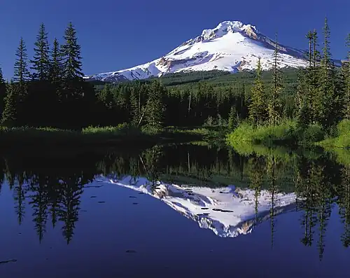
 Mount Hood
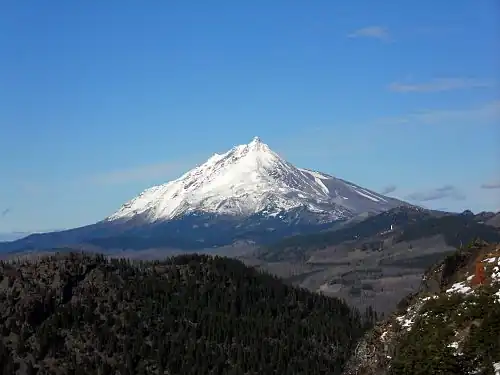 Mount Jefferson
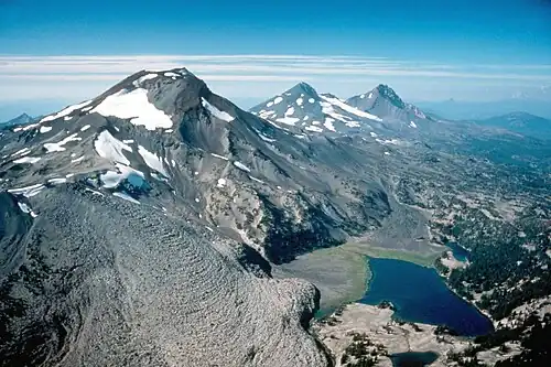 South Sister, Middle Sister, and North Sister
 Sacajawea Peak
 Steens Mountain
 Mount McLoughlin
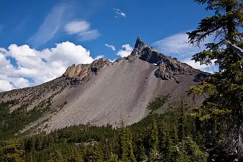 Mount Thielsen
See also
- List of mountain peaks of North America
- List of mountain peaks of Greenland
- List of mountain peaks of Canada
- List of mountain peaks of the Rocky Mountains
- List of mountain peaks of the United States
- List of mountain peaks of Alaska
- List of mountain peaks of Arizona
- List of mountain peaks of California
- List of mountain peaks of Colorado
- List of mountain peaks of Hawaiʻi
- List of mountain peaks of Idaho
- List of mountain peaks of Montana
- List of mountain peaks of Nevada
- List of mountain peaks of New Mexico
- List of mountain peaks of Oregon
- List of mountain peaks of Utah
- List of mountain peaks of Washington (state)
- List of mountain peaks of Wyoming
- List of mountain peaks of México
- List of mountain peaks of Central America
- List of mountain peaks of the Caribbean
- Oregon
- Geography of Oregon
- Category:Mountains of Oregon
- Geography of Oregon
- Physical geography
- Topography
- Topographic elevation
- Topographic prominence
- Topographic isolation
- Topography
Notes
- 1 2 3 The summit of Mount Hood is the highest point of the Oregon Cascades and the U.S. State of Oregon.
- 1 2 3 The elevation of Mount Jefferson includes an adjustment of +1.388 m (4.55 ft) from NGVD 29 to NAVD 88.
- ↑ The elevation of North Sister includes an adjustment of +1.395 m (4.58 ft) from NGVD 29 to NAVD 88.
- ↑ The elevation of Middle Sister includes an adjustment of +1.395 m (4.58 ft) from NGVD 29 to NAVD 88.
- 1 2 3 The summit of Sacajawea Peak is the highest point of the Wallowa Mountains and the Columbia Plateau.
- 1 2 3 The elevation of Sacajawea Peak includes an adjustment of +1.56 m (5.12 ft) from NGVD 29 to NAVD 88.
- 1 2 3 The elevation of Steens Mountain includes an adjustment of +1.496 m (4.91 ft) from NGVD 29 to NAVD 88.
- ↑ The elevation of Twin Peaks includes an adjustment of +1.523 m (5 ft) from NGVD 29 to NAVD 88.
- 1 2 3 The summit of Mount McLoughlin is the highest point of the southern Oregon Cascades.
- 1 2 3 The elevation of Mount McLoughlin includes an adjustment of +1.306 m (4.28 ft) from NGVD 29 to NAVD 88.
- ↑ The elevation of Elkhorn Peak includes an adjustment of +1.456 m (4.78 ft) from NGVD 29 to NAVD 88.
- ↑ The elevation of Broken Top includes an adjustment of +1.369 m (4.49 ft) from NGVD 29 to NAVD 88.
- 1 2 3 The elevation of Rock Creek Butte includes an adjustment of +1.389 m (4.56 ft) from NGVD 29 to NAVD 88.
- 1 2 3 The summit of Strawberry Mountain is the highest point of the Strawberry Range.
- 1 2 3 The summit of Pueblo Mountain is the highest point of the Pueblo Mountains.
- ↑ The elevation of Drake Peak includes an adjustment of +1.343 m (4.41 ft) from NGVD 29 to NAVD 88.
- 1 2 The summit elevation of Mount Bailey includes a vertical offset of +0.61 m (2 ft) from the station benchmark.
- 1 2 The elevation of Vinegar Hill includes an adjustment of +1.365 m (4.48 ft) from NGVD 29 to NAVD 88.
- ↑ The elevation of Lookout Mountain includes an adjustment of +1.457 m (4.78 ft) from NGVD 29 to NAVD 88.
- 1 2 The summit of Warner Peak is the highest point of Hart Mountain.
- 1 2 3 The summit of Paulina Peak is the highest point of the Paulina Mountains.
- 1 2 The summit of Rock Creek Butte is the highest point of the Blue Mountains.
- 1 2 The elevation of Brandy Peak includes an adjustment of +1.157 m (3.8 ft) from NGVD 29 to NAVD 88.
- 1 2 The summit of Mount Ashland is the highest point of the Siskiyou Mountains.
- 1 2 The summit of Rogers Peak is the highest point of the northern Oregon Coast Range.
- 1 2 The elevation of Rogers Peak includes an adjustment of +1.109 m (3.64 ft) from NGVD 29 to NAVD 88.
- ↑ The elevation of North Sister includes an adjustment of +1.395 m (4.58 ft) from NGVD 29 to NAVD 88.
- ↑ The elevation of Mount Washington includes an adjustment of +1.27 m (4.17 ft) from NGVD 29 to NAVD 88.
- ↑ The summit of Lookout Mountain is the highest point of the Ochoco Mountains.
- ↑ The elevation of Lookout Mountain includes an adjustment of +1.285 m (4.22 ft) from NGVD 29 to NAVD 88.
- ↑ The elevation of Black Mountain includes an adjustment of +1.216 m (3.99 ft) from NGVD 29 to NAVD 88.
References
- ↑ This article defines a significant summit as a summit with at least 100 meters (328.1 feet) of topographic prominence, and a major summit as a summit with at least 500 meters (1640 feet) of topographic prominence. All summits in this article have at least 500 meters of topographic prominence. An ultra-prominent summit is a summit with at least 1500 meters (4921 feet) of topographic prominence.
- ↑ All elevations in this article include an elevation adjustment from the National Geodetic Vertical Datum of 1929 (NGVD 29) to the North American Vertical Datum of 1988 (NAVD 88). For further information, please see this United States National Geodetic Survey note.
- 1 2 If the elevation or prominence of a summit is calculated as a range of values, the arithmetic mean is shown.
- ↑ The topographic prominence of a summit is the topographic elevation difference between the summit and its highest or key col to a higher summit. The summit may be near its key col or quite far away. The key col for Denali in Alaska is the Isthmus of Rivas in Nicaragua, 7642 kilometers (4749 miles) away.
- ↑ The topographic isolation of a summit is the great-circle distance to its nearest point of equal elevation.
- 1 2 3 "MOUNT HOOD HIGHEST POINT". Datasheet for NGS Station RC2244. U.S. National Geodetic Survey. Retrieved June 16, 2016.
- 1 2 3 "Mount Hood". Geographic Names Information System. United States Geological Survey, United States Department of the Interior.
- 1 2 3 "Mount Hood". Peakbagger.com. Retrieved June 16, 2016.
- 1 2 3 "Mount Hood". Bivouac.com. Retrieved June 16, 2016.
- 1 2 3 "MOUNT JEFFERSON". Datasheet for NGS Station QD1739. U.S. National Geodetic Survey. Retrieved June 16, 2016.
- 1 2 3 "Mount Jefferson". Geographic Names Information System. United States Geological Survey, United States Department of the Interior.
- 1 2 3 "Mount Jefferson". Peakbagger.com. Retrieved June 16, 2016.
- 1 2 3 "Mount Jefferson". Bivouac.com. Retrieved June 16, 2016.
- ↑ "SOUTH SISTER". Datasheet for NGS Station QD1872. U.S. National Geodetic Survey. Retrieved June 16, 2016.
- ↑ "South Sister". Geographic Names Information System. United States Geological Survey, United States Department of the Interior.
- ↑ "South Sister". Peakbagger.com. Retrieved June 16, 2016.
- ↑ "South Sister". Bivouac.com. Retrieved June 16, 2016.
- ↑ "NORTH SISTER". Datasheet for NGS Station QD1733. U.S. National Geodetic Survey. Retrieved June 16, 2016.
- ↑ "North Sister". Geographic Names Information System. United States Geological Survey, United States Department of the Interior.
- ↑ "North Sister". Peakbagger.com. Retrieved June 16, 2016.
- ↑ "North Sister". Bivouac.com. Retrieved June 16, 2016.
- ↑ "Middle SISTER". Datasheet for NGS Station QD1733. U.S. National Geodetic Survey. Retrieved June 16, 2016.
- ↑ "Middle Sister". Geographic Names Information System. United States Geological Survey, United States Department of the Interior.
- ↑ "Middle Sister". Peakbagger.com. Retrieved June 16, 2016.
- ↑ "Middle Sister". Bivouac.com. Retrieved June 16, 2016.
- 1 2 3 "Sacajawea Peak". Geographic Names Information System. United States Geological Survey, United States Department of the Interior.
- 1 2 3 "Sacajawea Peak". Peakbagger.com. Retrieved June 16, 2016.
- 1 2 3 "Sacajawea Peak". Bivouac.com. Retrieved June 16, 2016.
- 1 2 3 "Steens Mountain". Geographic Names Information System. United States Geological Survey, United States Department of the Interior.
- 1 2 3 "Steens Mountain". Peakbagger.com. Retrieved June 16, 2016.
- 1 2 3 "Steens Mountain". Bivouac.com. Retrieved June 16, 2016.
- ↑ "BONNY". Datasheet for NGS Station RA1065. U.S. National Geodetic Survey. Retrieved June 16, 2016.
- ↑ "Aneroid Mountain". Geographic Names Information System. United States Geological Survey, United States Department of the Interior.
- ↑ "Aneroid Mountain". Peakbagger.com. Retrieved June 16, 2016.
- ↑ "Aneroid Mountain". Bivouac.com. Retrieved June 16, 2016.
- ↑ "Twin Peaks". Geographic Names Information System. United States Geological Survey, United States Department of the Interior.
- ↑ "Twin Peaks". Peakbagger.com. Retrieved June 16, 2016.
- ↑ "Twin Peaks". Bivouac.com. Retrieved June 16, 2016.
- ↑ "Eagle Cap". Geographic Names Information System. United States Geological Survey, United States Department of the Interior.
- ↑ "Eagle Cap". Peakbagger.com. Retrieved October 10, 2022.
- ↑ "IMNAHA RESET". Datasheet for NGS Station RA1071. U.S. National Geodetic Survey. Retrieved June 16, 2016.
- ↑ "Red Mountain". Geographic Names Information System. United States Geological Survey, United States Department of the Interior.
- ↑ "Red Mountain". Peakbagger.com. Retrieved June 16, 2016.
- ↑ "Red Mountain". Bivouac.com. Retrieved June 16, 2016.
- 1 2 3 "MOUNT MCLOUGHLIN LOH". Datasheet for NGS Station NZ1067. U.S. National Geodetic Survey. Retrieved June 16, 2016.
- 1 2 3 "Mount McLoughlin". Geographic Names Information System. United States Geological Survey, United States Department of the Interior.
- 1 2 3 "Mount McLoughlin". Peakbagger.com. Retrieved June 16, 2016.
- 1 2 3 "Mount McLoughlin". Bivouac.com. Retrieved June 16, 2016.
- ↑ "Elkhorn Peak". Geographic Names Information System. United States Geological Survey, United States Department of the Interior.
- ↑ "Elkhorn Peak". Peakbagger.com. Retrieved June 16, 2016.
- ↑ "Elkhorn Peak". Bivouac.com. Retrieved June 16, 2016.
- 1 2 3 "MT THIELSEN". Datasheet for NGS Station PC0809. U.S. National Geodetic Survey. Retrieved June 16, 2016.
- 1 2 3 "Mount Thielsen". Geographic Names Information System. United States Geological Survey, United States Department of the Interior.
- 1 2 3 "Mount Thielsen". Peakbagger.com. Retrieved June 16, 2016.
- 1 2 3 "Mount Thielsen". Bivouac.com. Retrieved June 16, 2016.
- ↑ "Broken Top". Geographic Names Information System. United States Geological Survey, United States Department of the Interior.
- ↑ "Broken Top". Peakbagger.com. Retrieved June 16, 2016.
- ↑ "Broken Top". Bivouac.com. Retrieved June 16, 2016.
- 1 2 3 "Rock Creek Butte". Geographic Names Information System. United States Geological Survey, United States Department of the Interior.
- 1 2 3 "Rock Creek Butte". Peakbagger.com. Retrieved June 16, 2016.
- 1 2 3 "Rock Creek Butte". Bivouac.com. Retrieved June 16, 2016.
- ↑ "Krag Peak". Geographic Names Information System. United States Geological Survey, United States Department of the Interior.
- ↑ "Krag Peak". Peakbagger.com. Retrieved October 14, 2022.
- 1 2 "BACHELOR BUTTE". Datasheet for NGS Station PB0762. U.S. National Geodetic Survey. Retrieved June 16, 2016.
- 1 2 "Mount Bachelor". Geographic Names Information System. United States Geological Survey, United States Department of the Interior.
- 1 2 "Mount Bachelor". Peakbagger.com. Retrieved June 16, 2016.
- 1 2 "Mount Bachelor". Bivouac.com. Retrieved June 16, 2016.
- 1 2 3 "STRAWBERRY". Datasheet for NGS Station QC0909. U.S. National Geodetic Survey. Retrieved June 16, 2016.
- 1 2 3 "Strawberry Mountain". Geographic Names Information System. United States Geological Survey, United States Department of the Interior.
- 1 2 3 "Strawberry Mountain". Peakbagger.com. Retrieved June 16, 2016.
- 1 2 3 "Strawberry Mountain". Bivouac.com. Retrieved June 16, 2016.
- ↑ "Needle Point". Geographic Names Information System. United States Geological Survey, United States Department of the Interior.
- ↑ "Needle Point". Peakbagger.com. Retrieved October 10, 2022.
- 1 2 "MT SCOTT". Datasheet for NGS Station NZ1029. U.S. National Geodetic Survey. Retrieved June 16, 2016.
- 1 2 "Mount Scott". Geographic Names Information System. United States Geological Survey, United States Department of the Interior.
- 1 2 "Mount Scott". Peakbagger.com. Retrieved June 16, 2016.
- 1 2 "Mount Scott". Bivouac.com. Retrieved June 16, 2016.
- 1 2 3 "DIAMOND". Datasheet for NGS Station PC0781. U.S. National Geodetic Survey. Retrieved June 16, 2016.
- 1 2 3 "Diamond Peak". Geographic Names Information System. United States Geological Survey, United States Department of the Interior.
- 1 2 3 "Diamond Peak". Peakbagger.com. Retrieved June 16, 2016.
- 1 2 3 "Diamond Peak". Bivouac.com. Retrieved June 16, 2016.
- 1 2 3 "PUEBLO". Datasheet for NGS Station NX0253. U.S. National Geodetic Survey. Retrieved June 16, 2016.
- 1 2 3 "Pueblo Mountain". Geographic Names Information System. United States Geological Survey, United States Department of the Interior.
- 1 2 3 "Pueblo Mountain". Peakbagger.com. Retrieved June 16, 2016.
- 1 2 3 "Pueblo Mountain". Bivouac.com. Retrieved June 16, 2016.
- 1 2 "CRANE". Datasheet for NGS Station NY0777. U.S. National Geodetic Survey. Retrieved June 16, 2016.
- 1 2 "Crane Mountain". Geographic Names Information System. United States Geological Survey, United States Department of the Interior.
- 1 2 "Crane Mountain". Peakbagger.com. Retrieved June 16, 2016.
- 1 2 "Crane Mountain". Bivouac.com. Retrieved June 16, 2016.
- ↑ "DRAKE PEAK CAIRN". Datasheet for NGS Station NY0764. U.S. National Geodetic Survey. Retrieved June 16, 2016.
- ↑ "Drake Peak". Geographic Names Information System. United States Geological Survey, United States Department of the Interior.
- ↑ "Drake Peak". Peakbagger.com. Retrieved June 16, 2016.
- ↑ "Drake Peak". Bivouac.com. Retrieved June 16, 2016.
- 1 2 "BAILEY". Datasheet for NGS Station PC0817. U.S. National Geodetic Survey. Retrieved June 16, 2016.
- 1 2 "Mount Bailey". Geographic Names Information System. United States Geological Survey, United States Department of the Interior.
- 1 2 "Mount Bailey". Peakbagger.com. Retrieved June 16, 2016.
- 1 2 "Mount Bailey". Bivouac.com. Retrieved June 16, 2016.
- 1 2 3 "GEARHART". Datasheet for NGS Station NY0827. U.S. National Geodetic Survey. Retrieved June 16, 2016.
- 1 2 3 "Gearhart Mountain". Geographic Names Information System. United States Geological Survey, United States Department of the Interior.
- 1 2 3 "Gearhart Mountain". Peakbagger.com. Retrieved June 16, 2016.
- 1 2 3 "Gearhart Mountain". Bivouac.com. Retrieved June 16, 2016.
- 1 2 "ASPEN". Datasheet for NGS Station NZ1060. U.S. National Geodetic Survey. Retrieved June 16, 2016.
- 1 2 "Aspen Butte". Geographic Names Information System. United States Geological Survey, United States Department of the Interior.
- 1 2 "Aspen Butte". Peakbagger.com. Retrieved June 16, 2016.
- 1 2 "Aspen Butte". Bivouac.com. Retrieved June 16, 2016.
- 1 2 3 "YAMSAY MT". Datasheet for NGS Station NY0873. U.S. National Geodetic Survey. Retrieved June 16, 2016.
- 1 2 3 "Yamsay Mountain". Geographic Names Information System. United States Geological Survey, United States Department of the Interior.
- 1 2 3 "Yamsay Mountain". Peakbagger.com. Retrieved June 16, 2016.
- 1 2 3 "Yamsay Mountain". Bivouac.com. Retrieved June 16, 2016.
- 1 2 "VINEGAR HILL LOH". Datasheet for NGS Station QC0925. U.S. National Geodetic Survey. Retrieved June 16, 2016.
- 1 2 "Vinegar Hill". Geographic Names Information System. United States Geological Survey, United States Department of the Interior.
- 1 2 "Vinegar Hill". Peakbagger.com. Retrieved June 16, 2016.
- 1 2 "Vinegar Hill". Bivouac.com. Retrieved June 16, 2016.
- ↑ "PELICAN". Datasheet for NGS Station NZ1044. U.S. National Geodetic Survey. Retrieved June 16, 2016.
- ↑ "Pelican Butte". Geographic Names Information System. United States Geological Survey, United States Department of the Interior.
- ↑ "Pelican Butte". Peakbagger.com. Retrieved June 16, 2016.
- ↑ "Pelican Butte". Bivouac.com. Retrieved June 16, 2016.
- ↑ "Lookout Mountain". Geographic Names Information System. United States Geological Survey, United States Department of the Interior.
- ↑ "Lookout Mountain". Peakbagger.com. Retrieved June 16, 2016.
- ↑ "Lookout Mountain". Bivouac.com. Retrieved June 16, 2016.
- 1 2 "HART". Datasheet for NGS Station NX0282. U.S. National Geodetic Survey. Retrieved June 16, 2016.
- 1 2 "Warner Peak". Geographic Names Information System. United States Geological Survey, United States Department of the Interior.
- 1 2 "Warner Peak". Peakbagger.com. Retrieved June 16, 2016.
- 1 2 "Warner Peak". Bivouac.com. Retrieved June 16, 2016.
- 1 2 3 "PAULINA PEAK BM". Datasheet for NGS Station PB0696. U.S. National Geodetic Survey. Retrieved June 16, 2016.
- 1 2 3 "Paulina Peak". Geographic Names Information System. United States Geological Survey, United States Department of the Interior.
- 1 2 3 "Paulina Peak". Peakbagger.com. Retrieved June 16, 2016.
- 1 2 3 "Paulina Peak". Bivouac.com. Retrieved June 16, 2016.
- 1 2 "SOUTH SISTER". Datasheet for NGS Station QD1872. U.S. National Geodetic Survey. Retrieved June 16, 2016.
- 1 2 "South Sister". Geographic Names Information System. United States Geological Survey, United States Department of the Interior.
- 1 2 "South Sister". Peakbagger.com. Retrieved June 16, 2016.
- 1 2 "South Sister". Bivouac.com. Retrieved June 16, 2016.
- 1 2 "Brandy Peak". Geographic Names Information System. United States Geological Survey, United States Department of the Interior.
- 1 2 "Brandy Peak". Peakbagger.com. Retrieved June 16, 2016.
- 1 2 "Brandy Peak". Bivouac.com. Retrieved June 16, 2016.
- 1 2 "MARY RM 5". Datasheet for NGS Station QE2316. U.S. National Geodetic Survey. Retrieved June 16, 2016.
- 1 2 "Marys Peak". Geographic Names Information System. United States Geological Survey, United States Department of the Interior.
- 1 2 "Marys Peak". Peakbagger.com. Retrieved June 16, 2016.
- 1 2 "Marys Peak". Bivouac.com. Retrieved June 16, 2016.
- 1 2 "ASHLAND PK RESET". Datasheet for NGS Station NZ1080. U.S. National Geodetic Survey. Retrieved June 16, 2016.
- 1 2 "Mount Ashland". Geographic Names Information System. United States Geological Survey, United States Department of the Interior.
- 1 2 "Mount Ashland". Peakbagger.com. Retrieved June 16, 2016.
- 1 2 "Mount Ashland". Bivouac.com. Retrieved June 16, 2016.
- ↑ "LOOKOUT". Datasheet for NGS Station QB1216. U.S. National Geodetic Survey. Retrieved June 16, 2016.
- ↑ "Big Lookout Mountain". Geographic Names Information System. United States Geological Survey, United States Department of the Interior.
- ↑ "Big Lookout Mountain". Peakbagger.com. Retrieved June 16, 2016.
- ↑ "Big Lookout Mountain". Bivouac.com. Retrieved June 16, 2016.
- ↑ "BLACK BUTTE 2". Datasheet for NGS Station QD1848. U.S. National Geodetic Survey. Retrieved June 16, 2016.
- ↑ "Black Butte". Geographic Names Information System. United States Geological Survey, United States Department of the Interior.
- ↑ "Black Butte". Peakbagger.com. Retrieved June 16, 2016.
- ↑ "Black Butte". Bivouac.com. Retrieved June 16, 2016.
- 1 2 "Rogers Peak". Geographic Names Information System. United States Geological Survey, United States Department of the Interior.
- 1 2 "Rogers Peak". Peakbagger.com. Retrieved June 16, 2016.
- 1 2 "LAUREL". Datasheet for NGS Station QE2309. U.S. National Geodetic Survey. Retrieved June 16, 2016.
- 1 2 "Laurel Mountain". Geographic Names Information System. United States Geological Survey, United States Department of the Interior.
- 1 2 "Laurel Mountain". Peakbagger.com. Retrieved June 16, 2016.
- ↑ "NORTH SISTER". Datasheet for NGS Station QD1733. U.S. National Geodetic Survey. Retrieved June 16, 2016.
- ↑ "North Sister". Geographic Names Information System. United States Geological Survey, United States Department of the Interior.
- ↑ "North Sister". Peakbagger.com. Retrieved June 16, 2016.
- ↑ "North Sister". Bivouac.com. Retrieved June 16, 2016.
- ↑ "PEARSOLL". Datasheet for NGS Station NZ1297. U.S. National Geodetic Survey. Retrieved June 16, 2016.
- ↑ "Pearsoll Peak". Geographic Names Information System. United States Geological Survey, United States Department of the Interior.
- ↑ "Pearsoll Peak". Peakbagger.com. Retrieved June 16, 2016.
- ↑ "Pearsoll Peak". Bivouac.com. Retrieved June 16, 2016.
- ↑ "MAIDEN". Datasheet for NGS Station PB0769. U.S. National Geodetic Survey. Retrieved June 16, 2016.
- ↑ "Maiden Peak". Geographic Names Information System. United States Geological Survey, United States Department of the Interior.
- ↑ "Maiden Peak". Peakbagger.com. Retrieved June 16, 2016.
- ↑ "Maiden Peak". Bivouac.com. Retrieved June 16, 2016.
- ↑ "MOUNT WASHINGTON". Datasheet for NGS Station QD1736. U.S. National Geodetic Survey. Retrieved June 16, 2016.
- ↑ "Mount Washington". Geographic Names Information System. United States Geological Survey, United States Department of the Interior.
- ↑ "Mount Washington". Peakbagger.com. Retrieved June 16, 2016.
- ↑ "Mount Washington". Bivouac.com. Retrieved June 16, 2016.
- ↑ "Lookout Mountain". Peakbagger.com. Retrieved June 16, 2016.
- ↑ "Lookout Mountain". Bivouac.com. Retrieved June 16, 2016.
- ↑ "Black Mountain". Geographic Names Information System. United States Geological Survey, United States Department of the Interior.
- ↑ "Black Mountain". Peakbagger.com. Retrieved June 16, 2016.
- ↑ "SNOW MT". Datasheet for NGS Station PA0712. U.S. National Geodetic Survey. Retrieved June 16, 2016.
- ↑ "Snow Mountain". Geographic Names Information System. United States Geological Survey, United States Department of the Interior.
- ↑ "Snow Mountain". Peakbagger.com. Retrieved June 16, 2016.
- ↑ "Snow Mountain". Bivouac.com. Retrieved June 16, 2016.
- ↑ "ROMAN 2". Datasheet for NGS Station PC1073. U.S. National Geodetic Survey. Retrieved June 16, 2016.
- ↑ "Roman Nose Mountain". Geographic Names Information System. United States Geological Survey, United States Department of the Interior.
- ↑ "Roman Nose Mountain". Peakbagger.com. Retrieved June 16, 2016.
- ↑ "DRY". Datasheet for NGS Station QB1245. U.S. National Geodetic Survey. Retrieved June 16, 2016.
- ↑ "Cottonwood Mountain". Peakbagger.com. Retrieved June 16, 2016.
- ↑ "Cottonwood Mountain". Bivouac.com. Retrieved June 16, 2016.
- ↑ "SADDLE MOUNTAIN 3 RESET". Datasheet for NGS Station RD1964. U.S. National Geodetic Survey. Retrieved June 16, 2016.
- ↑ "Saddle Mountain". Geographic Names Information System. United States Geological Survey, United States Department of the Interior.
- ↑ "Saddle Mountain". Peakbagger.com. Retrieved June 16, 2016.
- ↑ "BEATY". Datasheet for NGS Station NX0280. U.S. National Geodetic Survey. Retrieved June 16, 2016.
- ↑ "Beatys Butte". Geographic Names Information System. United States Geological Survey, United States Department of the Interior.
- ↑ "Beatys Butte". Peakbagger.com. Retrieved June 16, 2016.
- ↑ "Beatys Butte". Bivouac.com. Retrieved June 16, 2016.
- ↑ "BALD MTN". Datasheet for NGS Station PB0722. U.S. National Geodetic Survey. Retrieved June 16, 2016.
- ↑ "Bald Mountain". Geographic Names Information System. United States Geological Survey, United States Department of the Interior.
- ↑ "Bald Mountain". Peakbagger.com. Retrieved June 16, 2016.
- ↑ "Bald Mountain". Bivouac.com. Retrieved June 16, 2016.
- ↑ "YONNA". Datasheet for NGS Station NY0900. U.S. National Geodetic Survey. Retrieved June 16, 2016.
- ↑ "Yainax Butte". Geographic Names Information System. United States Geological Survey, United States Department of the Interior.
- ↑ "Yainax Butte". Peakbagger.com. Retrieved June 16, 2016.
- ↑ "Yainax Butte". Bivouac.com. Retrieved June 16, 2016.
External links
- United States Geological Survey (USGS)
- United States National Geodetic Survey (NGS)
- Bivouac.com
- Peakbagger.com
- Peaklist.org
- Peakware.com
- Summitpost.org
State of Oregon | |||||||||
|---|---|---|---|---|---|---|---|---|---|
Salem (capital) | |||||||||
| Topics |
| ||||||||
| Society |
| ||||||||
| Regions |
| ||||||||
| Metro areas |
| ||||||||
| Largest cities |
| ||||||||
| Counties |
| ||||||||
| |||||||||