Kakan Rural District
Kakan Rural District
Persian: دهستان كاكان | |
|---|---|
Rural District | |
 Kakan Rural District | |
| Coordinates: 30°38′36″N 51°44′59″E / 30.64333°N 51.74972°E[1] | |
| Country | Iran |
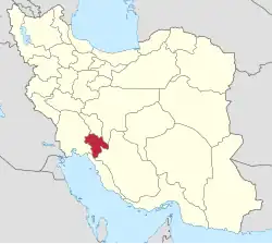
| Province | Kohgiluyeh and Boyer-Ahmad |
| County | Boyer-Ahmad |
| District | Central |
| Capital | Mansurkhani |
| Population (2016)[2] | |
• Total | 1,708 |
| Time zone | UTC+3:30 (IRST) |
Kakan Rural District (Persian: دهستان كاكان) is in the Central District of Boyer-Ahmad County, Kohgiluyeh and Boyer-Ahmad province, Iran. Its capital is the village of Mansurkhani.[3][4][a] The previous capital of the rural district was the village of Abbas Ali Khani.[5]
Demographics
Population
At the time of the 2006 National Census, the rural district's population was 2,281 in 497 households.[6] There were 1,975 inhabitants in 488 households at the following census of 2011.[7] The 2016 census measured the population of the rural district as 1,708 in 502 households. The most populous of its 24 villages was Mansurkhani, with 390 people.[2]
History
The district was buried, leaving no survivors, during the 1972 Iran blizzard.[8]
See also
![]() Iran portal
Iran portal
Notes
References
- ↑ OpenStreetMap contributors (24 December 2024). "Kakan Rural District (Boyer-Ahmad County)" (Map). OpenStreetMap (in Persian). Retrieved 24 December 2024.
- 1 2 Census of the Islamic Republic of Iran, 1395 (2016): Kohgiluyeh and Boyer-Ahmad Province. amar.org.ir (Report) (in Persian). The Statistical Center of Iran. Archived from the original (Excel) on 2 November 2021. Retrieved 19 December 2022.
- 1 2 Aref, Mohammad Reza (c. 2024) [Approved 9 October 1383]. Divisional changes and reforms in Kohgiluyeh and Boyer-Ahmad province. lamtakam.com (Report) (in Persian). Ministry of the Interior, Political-Defense Commission of the Government Board. Proposal 1.4.42.33009; Letter 58538T/26118H; Notification 31808/T31026K. Archived from the original on 25 January 2024. Retrieved 25 January 2024 – via Lam ta Kam.
- ↑ Cancellation of part of the approval letter No. 696/T84K dated 18/1/1372 of the Council of Ministers. lamtakam.com (Report) (in Persian). Government Legal Affairs Office. c. 2024 [Approved 25 November 1383]. Case 585-586; Case class 81/120-121. Archived from the original on 24 December 2024. Retrieved 24 December 2024 – via Lam ta Kam.
- ↑ Habibi, Hassan (c. 2018) [Approved 12 December 1371]. Creation of 48 rural districts in several rural areas of the country. qavanin.ir (Report) (in Persian). Ministry of the Interior, Political-Defense Commission of the Government Council. Resolution 93808/T907. Archived from the original on 28 November 2018. Retrieved 2 January 2024 – via Laws and Regulations Portal of the Islamic Republic of Iran.
- ↑ Census of the Islamic Republic of Iran, 1385 (2006): Kohgiluyeh and Boyer-Ahmad Province. amar.org.ir (Report) (in Persian). The Statistical Center of Iran. Archived from the original (Excel) on 20 September 2011. Retrieved 25 September 2022.
- ↑ Census of the Islamic Republic of Iran, 1390 (2011): Kohgiluyeh and Boyer-Ahmad Province. irandataportal.syr.edu (Report) (in Persian). The Statistical Center of Iran. Archived from the original (Excel) on 19 January 2023. Retrieved 19 December 2022 – via Iran Data Portal, Syracuse University.
- ↑ Edwards, Haley Sweetland (7 February 2012). "40 Years Ago, Iran Was Hit by the Deadliest Blizzard in History". Mental Floss. Retrieved 9 August 2019.
Kohgiluyeh and Boyer-Ahmad province, Iran | |||||||||||||||||||
|---|---|---|---|---|---|---|---|---|---|---|---|---|---|---|---|---|---|---|---|
| Capital |
|  | |||||||||||||||||
| Counties and cities |
| ||||||||||||||||||
| Sights |
| ||||||||||||||||||
| populated places |
| ||||||||||||||||||
This article is issued from Wikipedia. The text is licensed under Creative Commons - Attribution - Sharealike. Additional terms may apply for the media files.