Gilan-e Gharb County
Gilan-e Gharb County
Persian: شهرستان گیلان غرب | |
|---|---|
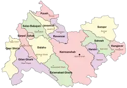 Location of Gilan-e Gharb County in Kermanshah province (left, purple) | |
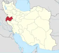 Location of Kermanshah province in Iran | |
| Coordinates: 34°08′N 46°10′E / 34.133°N 46.167°E[1] | |
| Country | Iran |
| Province | Kermanshah |
| Capital | Gilan-e Gharb |
| Districts | Central, Gowavar |
| Population (2016)[2] | |
• Total | 57,007 |
| Time zone | UTC+3:30 (IRST) |
| Gilan-e Gharb County can be found at GEOnet Names Server, at this link, by opening the Advanced Search box, entering "9206882" in the "Unique Feature Id" form, and clicking on "Search Database". | |
Gilan-e Gharb County (Persian: شهرستان گیلان غرب)[a] is in Kermanshah province, Iran. Its capital is the city of Gilan-e Gharb.[3]
Demographics
Language
People in Gilan-e Gharb speak Kurdish (Kalhori).[4]
Population
At the time of the 2006 National Census, the county's population was 60,671 in 13,452 households.[5] The following census in 2011 counted 62,858 people in 15,619 households.[6] The 2016 census measured the population of the county as 57,007 in 16,570 households.[2]
Administrative divisions
Gilan-e Gharb County's population history and administrative structure over three consecutive censuses are shown in the following table.
| Administrative Divisions | 2006[5] | 2011[6] | 2016[2] |
|---|---|---|---|
| Central District | 41,648 | 43,424 | 40,122 |
| Cheleh RD | 8,488 | 9,745 | 6,361 |
| Direh RD | 4,530 | 4,180 | 3,600 |
| Howmeh RD | 6,684 | 6,111 | 5,030 |
| Vizhenan RD | 2,515 | 2,466 | 2,800 |
| Gilan-e Gharb (city) | 19,431 | 20,922 | 22,331 |
| Gowavar District | 19,023 | 18,170 | 16,333 |
| Gowavar RD | 8,699 | 7,917 | 6,801 |
| Heydariyeh RD | 7,890 | 7,395 | 6,619 |
| Sarmast (city) | 2,434 | 2,858 | 2,913 |
| Total | 60,671 | 62,858 | 57,007 |
| RD = Rural District | |||
See also
![]() Media related to Gilan-e Gharb County at Wikimedia Commons
Media related to Gilan-e Gharb County at Wikimedia Commons
Notes
- ↑ Also romanized as Gellan (Kurdish: گێڵان and گیەڵان)
References
- ↑ OpenStreetMap contributors (11 December 2024). "Gilan-e Gharb County" (Map). OpenStreetMap (in Persian). Retrieved 11 December 2024.
- 1 2 3 Census of the Islamic Republic of Iran, 1395 (2016): Kermanshah Province. amar.org.ir (Report) (in Persian). The Statistical Center of Iran. Archived from the original (Excel) on 3 April 2022. Retrieved 19 December 2022.
- ↑ Habibi, Hassan (19 November 2013) [Approved 21 June 1369]. Approval of the organization and chain of citizenship of the elements and units of the national divisions of Bakhtran province, centered in the city of Bakhtran. rc.majlis.ir (Report) (in Persian). Ministry of the Interior, Defense Political Commission of the Government Board. Proposal 3233.1.5.53; Letter 93808/907; Notification 82832/T122K. Archived from the original on 6 February 2013. Retrieved 29 January 2024 – via Research Center of the System of Laws of the Islamic Council of Farabi Mobile Library.
- ↑ Kurdpa News
- 1 2 Census of the Islamic Republic of Iran, 1385 (2006): Kermanshah Province. amar.org.ir (Report) (in Persian). The Statistical Center of Iran. Archived from the original (Excel) on 20 September 2011. Retrieved 25 September 2022.
- 1 2 Census of the Islamic Republic of Iran, 1390 (2011): Kermanshah Province. irandataportal.syr.edu (Report) (in Persian). The Statistical Center of Iran. Archived from the original (Excel) on 18 January 2023. Retrieved 19 December 2022 – via Iran Data Portal, Syracuse University.
Kermanshah province, Iran | |||||||||||||||||||||||||||||
|---|---|---|---|---|---|---|---|---|---|---|---|---|---|---|---|---|---|---|---|---|---|---|---|---|---|---|---|---|---|
| Capital |
|  | |||||||||||||||||||||||||||
| Counties and cities |
| ||||||||||||||||||||||||||||
| Sights |
| ||||||||||||||||||||||||||||
| populated places |
| ||||||||||||||||||||||||||||
This article is issued from Wikipedia. The text is licensed under Creative Commons - Attribution - Sharealike. Additional terms may apply for the media files.