Geographical regions of Turkey
| Regions of Turkey Türkiye'nin bölgeleri (Turkish) | |
|---|---|
%252C_administrative_divisions_-_Nmbrs.svg.png) Regions (by number)
| |
| Category | Unitary state |
| Location | Turkish Republic |
| Number | 7 |
| Populations | 6,513,106 (Eastern Anatolia) – 26,650,405 (Marmara) |
| Areas | 59,176 km2 (22,848 sq mi) (Southeastern Anatolia Region) – 165,436 km2 (63,875 sq mi) (Eastern Anatolia Region) |
| Government |
|
| Subdivisions |
|
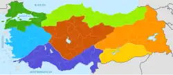
Map of the geographic regions, color-coded, with national (gray) and provincial borders (white).
List of geographical regions
- Marmara Region (dark green)
- Black Sea Region (light green)
- Aegean Region (blue)
- Mediterranean Region (purple)
- Central Anatolia Region (brown)
- Eastern Anatolia Region (orange)
- Southeastern Anatolia Region (yellow)
The geographical regions of Turkey comprise seven regions (Turkish: bölge), which were originally defined at the country's First Geography Congress in 1941.[1] The regions are subdivided into 31 sections (Turkish: bölüm), which are further divided into numerous areas (Turkish: yöre), as defined by microclimates and bounded by local geographic formations.
"Regions" as defined in this context are merely for geographic, demographic, and economic purposes and do not refer to an administrative division.
Regions and subregions
| Region | Largest city | Area | Provinces (Counties) | Population (2021) | Location | |
|---|---|---|---|---|---|---|
| km2 | sq mi | |||||
| Aegean Region | İzmir | 85,000 | 33,000 | 8 | 10,477,153 | |
| Black Sea Region | Samsun | 143,537 | 55,420 | 18 | 7,696,132 | |
| Central Anatolia Region | Ankara | 163,057 | 62,957 | 13 | 12,896,255 | |
| Eastern Anatolia Region | Erzurum | 165,436 | 63,875 | 14 | 6,513,106 | |
| Marmara Region | Istanbul | 67,000 | 26,000 | 11 | 26,650,405 | |
| Mediterranean Region | Antalya | 122,927 | 47,462 | 8 | 10,584,506 | |
| Southeastern Anatolia Region | Şanlıurfa | 59,176 | 22,848 | 9 | 8,576,391 | |
Aegean Region
- Aegean Region
- Aegean Section
- Edremit Area
- Bakirçay Area
- Gediz Area
- İzmir Area
- Küçük Menderes Area
- Büyük Menderes Area
- Mentese Area
- Inner Western Anatolia Section
- Aegean Section
Black Sea Region
- Black Sea Region
- Western Black Sea Section
- Inner Black Sea Area
- Küre Mountains Area
- Central Black Sea Section
- Canik Mountains Area
- Inner Central Black Sea Area
- Eastern Black Sea Section
- Eastern Black Sea Coast Area
- Upper Kelkit - Çoruh Gully Area
- Western Black Sea Section
Central Anatolia Region
- Central Anatolia Region
- Konya Section
- Obruk Plateau
- Konya - Ereğli Vicinity
- Upper Sakarya Section
- Ankara Area
- Porsuk Gully Area
- Sündiken Mountain Chain Area
- Upper Sakarya Area
- Konya - Ereğli Vicinity
- Middle Kizilirmak Section
- Upper Kizilirmak Section
- Konya Section
Eastern Anatolia Region
- Eastern Anatolia Region
- Upper Euphrates Section
- Erzurum - Kars Section
- Upper Murat - Van Section
- Upper Murat Area
- Van Area
- Hakkâri Section
Marmara Region
- Marmara Region
- Çatalca - Kocaeli Section
- Adapazarı Area
- Istanbul Area
- Ergene Section
- Southern Marmara Section
- Biga - Gallipoli Area
- Bursa Area
- Karesi Area
- Samanlı Area
- Yıldız Section
- Çatalca - Kocaeli Section
Mediterranean Region
- Mediterranean Region
- Adana Section
- Çukurova - Taurus Mountains Area
- Antakya - Kahramanmaras Area
- Antalya Section
- Antalya Area
- Göller Area
- Taseli - Mut Area
- Teke Area
- Adana Section
Southeastern Anatolia Region
- Southeastern Anatolia Region
- Middle Euphrates Section
- Gaziantep Area
- Şanlıurfa Area
- Tigris Section
- Diyarbakır Area
- Mardin - Midyat Area
- Middle Euphrates Section
Distinctions of the regions
The Aegean Region has:
- the longest coastline

Artvin Province, East of the Blacksea Region
The Black Sea Region has:
- highest annual precipitation
- largest forest area
- fewest sunshine hours
- most landslides

Cappadoccia and famous fairy chimneys rock formation
The Central Anatolia Region has:
- lowest annual precipitation,
- most erosion
The Eastern Anatolia Region has:
- largest area
- highest elevation
- lowest annual temperature
- coldest winters
- highest temperature difference between seasons
- most volcanic activity
- smallest population
- highest mineral resources

Istanbul, the most populous city in the Marmara Region and all of Turkey
The Marmara Region has:
- smallest area
- lowest elevation
- most climate diversity
- highest energy consumption,
- coolest summers,
- largest population
.jpg)
The Mediterranean Region is a well-known sea-tourism zone because of own climate.
The Mediterranean Region has:
- highest annual temperature
- mildest winters
- wettest winters,
- most greenhouse farming
The Southeastern Anatolia Region has:
- hottest summers
- driest summers
- smallest forest area
- most sunshine hours
See also
- Provinces of Turkey
- Districts of Turkey
- Villages of Turkey
- Metropolitan centers in Turkey
References
- ↑ Ali Yiğit, "Geçmişten Günümüze Türkiye'yi Bölgelere Ayıran Çalışmalar ve Yapılması Gerekenler", Ankara Üniversitesi Türkiye Coğrafyası Araştırma ve Uygulama Merkezi, IV. Ulural Coğrafya Sempozyumu, "Avrupa Birliği Sürecindeki Türkiye'de Bölgesel Farklılıklar", pp. 34–35. Archived 2012-03-31 at the Wayback Machine
Geographical regions of Turkey | ||
|---|---|---|
| ||
| Sovereign states |
|
|---|---|
| States with limited recognition |
|
| Dependencies and other territories |
|
| |
This article is issued from Wikipedia. The text is licensed under Creative Commons - Attribution - Sharealike. Additional terms may apply for the media files.