Garmsar County
Garmsar County
Persian: شهرستان گرمسار | |
|---|---|
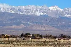 Alborz Mountains | |
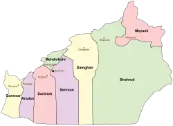 Location of Garmsar County in Semnan Province (left, yellow) | |
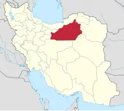 Location of Semnan province in Iran | |
| Coordinates: 34°59′38″N 52°10′32″E / 34.99389°N 52.17556°E[1] | |
| Country | |
| Province | Semnan |
| Capital | Garmsar |
| Districts | Central, Eyvanki |
| Population (2016)[2] | |
• Total | 77,421 |
| Time zone | UTC+3:30 (IRST) |
| Garmsar County can be found at GEOnet Names Server, at this link, by opening the Advanced Search box, entering "9206418" in the "Unique Feature Id" form, and clicking on "Search Database". | |
Garmsar County (Persian: شهرستان گرمسار) is in Semnan Province, Iran. Its capital is the city of Garmsar.[3]
History
After the 2011 National Census, Aradan District was separated from the county in the establishment of Aradan County.[4]
Demographics
Languages
The main languages of the county are Persian (Central District) and Tati (Eyvanki District).[5]
Population
At the time of the 2006 census, the county's population was 77,676 in 21,706 households.[6] The following census in 2011 counted 81,324 people in 24,858 households.[7] The 2016 census measured the population of the county as 77,421 in 25,585 households.[2]
Administrative divisions
Garmsar County's population history and administrative structure over three consecutive censuses are shown in the following table.
| Administrative Divisions | 2006[6] | 2011[7] | 2016[2] |
|---|---|---|---|
| Central District | 49,071 | 50,892 | 60,258 |
| Howmeh RD | 3,285 | 3,554 | 4,072 |
| Lajran RD | 6,895 | 6,353 | 7,514 |
| Garmsar (city) | 38,891 | 40,985 | 48,672 |
| Aradan District[a] | 15,418 | 15,575 | |
| Kohanabad RD | 4,745 | 3,768 | |
| Yateri RD | 5,714 | 6,181 | |
| Aradan (city) | 4,959 | 5,626 | |
| Eyvanki District | 13,187 | 14,857 | 17,163 |
| Eyvanki RD | 2,791 | 2,862 | 3,645 |
| Eyvanki (city) | 10,396 | 11,995 | 13,518 |
| Total | 77,676 | 81,324 | 77,421 |
| RD = Rural District | |||
See also
![]() Media related to Garmsar County at Wikimedia Commons
Media related to Garmsar County at Wikimedia Commons
![]() Iran portal
Iran portal
Notes
- ↑ Transferred to Aradan County[4]
References
- ↑ OpenStreetMap contributors (7 January 2025). "Garmsar County" (Map). OpenStreetMap (in Persian). Retrieved 7 January 2025.
- 1 2 3 Census of the Islamic Republic of Iran, 1395 (2016): Semnan Province. amar.org.ir (Report) (in Persian). The Statistical Center of Iran. Archived from the original (Excel) on 17 November 2020. Retrieved 19 December 2022.
- ↑ Habibi, Hassan (c. 2024) [Approved 21 June 1369]. Approval of the organization and chain of citizenship of the elements and units of the national divisions of Semnan province, centered in Semnan city. lamtakam.com (Report) (in Persian). Ministry of the Interior, Defense Political Commission of the Government Council. Proposal 3233.1.5.53; Letter 93808-907; Notification 82836/T140K. Archived from the original on 2 January 2024. Retrieved 2 January 2024 – via Lam ta Kam.
- 1 2 Rahimi, Mohammad Reza (25 June 2011) [Approved 16 May 1390]. Approval decree regarding the establishment of Aradan County with the city of Aradan as its center in Semnan province. rc.majlis.ir (Report) (in Persian). Ministry of the Interior, Cabinet of Ministers. Proposal 50184/42/4/1; Notification 103694/T46975AH. Archived from the original on 16 September 2011. Retrieved 6 January 2025 – via Research Center of the Islamic Consultative Assembly of Iran.
- ↑ Eyvanki area: Tati language (in Persian)
- 1 2 Census of the Islamic Republic of Iran, 1385 (2006): Semnan Province. amar.org.ir (Report) (in Persian). The Statistical Center of Iran. Archived from the original (Excel) on 20 September 2011. Retrieved 25 September 2022.
- 1 2 Census of the Islamic Republic of Iran, 1390 (2011): Semnan Province. irandataportal.syr.edu (Report) (in Persian). The Statistical Center of Iran. Archived from the original (Excel) on 20 January 2023. Retrieved 19 December 2022 – via Iran Data Portal, Syracuse University.
Semnan province, Iran | |||||||||||||||||
|---|---|---|---|---|---|---|---|---|---|---|---|---|---|---|---|---|---|
| Capital | 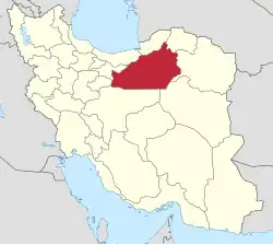 | ||||||||||||||||
| Counties and cities |
| ||||||||||||||||
| Sights |
| ||||||||||||||||
| populated places |
| ||||||||||||||||
| Capital |
| ||||||||||||||||||
|---|---|---|---|---|---|---|---|---|---|---|---|---|---|---|---|---|---|---|---|
| Districts |
| ||||||||||||||||||