Extreme points of Azerbaijan
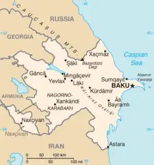
Map of Azerbaijan
This is a list of the extreme points of Azerbaijan, the points that are farther north, south, east or west than any other location.
Latitude and longitude
Azerbaijan
This section includes only the central contiguous section of Azerbaijan.
- North: Khachmaz Rayon (41°54′N 46°25′E / 41.900°N 46.417°E)
- South: near Tangov, Astara (38°24′N 48°39′E / 38.400°N 48.650°E)
- West:
- Near İkinci Şıxlı, Qazakh (41°18′N 45°0′E / 41.300°N 45.000°E)
- The nearby enclave of Yuxari Askipara; is marginally further west (41°04′N 45°01′E / 41.067°N 45.017°E).
- East: Çilov, Baku (40°18′N 50°33′E / 40.300°N 50.550°E)
Nakhchivan
This section includes only the exclave of Nakhchivan.
- North:
- Near Günnüt, Sharur (39°46′N 45°4′E / 39.767°N 45.067°E)
- The enclave of Karki; extends slightly further north (39°48′N 44°58′E / 39.800°N 44.967°E).
- South: Ordubad (38°51′N 46°9′E / 38.850°N 46.150°E)
- West: Sadarak Rayon (39°42′N 44°46′E / 39.700°N 44.767°E)
- East: Ordubad (38°51′N 46°9′E / 38.850°N 46.150°E)
Altitude
- Maximum: Bazardüzü Dağı, 4,466 m[1] (41°13′14″N 47°51′28″E / 41.22056°N 47.85778°E)
- Minimum: Caspian Sea, -28 m[1]
See also
References
- 1 2 "Azerbaijan". The World Factbook (2025 ed.). Central Intelligence Agency.
| Sovereign states |
|
|---|---|
| States with limited recognition |
|
| Dependencies and other territories |
|
| |
This article is issued from Wikipedia. The text is licensed under Creative Commons - Attribution - Sharealike. Additional terms may apply for the media files.