Catalan Mediterranean System
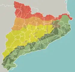
Geomorphologic map of Catalonia (The green Southern Zone extends 80 km further south into the Valencian community):
- Pyrenees
- Pre-Pyrenees
- Catalan Central Depression
- Smaller mountain ranges of the Central Depression
- Catalan Transversal Range
- Catalan Pre-Coastal Range
- Catalan Coastal Range
- Catalan Coastal Depression and other coastal and pre-coastal plains
The Catalan Mediterranean System, also known as Mediterranean System, Transversal Ibero-Pyrenaean System, and Catalanid System,[1] is a wide coastal geographical region in Catalonia. It is made up of a double system of coastal mountain chains: The Catalan Coastal Range and the Catalan Pre-Coastal Range, as well as the Catalan Coastal Depression and other coastal and pre-coastal plains located among those mountain ranges.
Geology
Geologically the Catalan Mediterranean System is the result of a tectonic uplift, about 300 km long and roughly 50 km wide.
Transversally the system can be divided in three zones:
- Northern Zone, between the Empordà comarca and the Llobregat. This zone is of paleozoic and crystalline composition
- Central Zone, between rivers Llobregat and Ebre
- Southern Zone, between the Baix Ebre comarca and the Millars River in the Valencian Community. Both the central and the southern zone are of mesozoic and tertiary composition.
See also
- Catalan Coastal Range
- Catalan Pre-Coastal Range
- Catalan Coastal Depression
References
- ↑ Josep Guitart i Duran, Maria del Tura Bolòs et al. Història agrària dels Països Catalans (Volum 1) Antiguitat, 2005, ISBN 978-84-475-2895-0
External links
- El Relleu - Grup Enciclopèdia Catalana
- Sistema Mediterrani Català - Fundació Torre del Palau
- El Sistema Mediterrani - Regions Naturals de Catalunya
41°41′21.56″N 2°34′39.6″E / 41.6893222°N 2.577667°E
Mountain ranges of Spain | ||
|---|---|---|
This article is issued from Wikipedia. The text is licensed under Creative Commons - Attribution - Sharealike. Additional terms may apply for the media files.