Bileh Savar County
Bileh Savar County
Persian: شهرستان بیله سوار | |
|---|---|
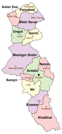 Location of Bileh Savar County in Ardabil province (top, purple) | |
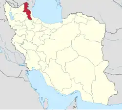 Location of Ardabil province in Iran | |
| Coordinates: 39°20′N 48°00′E / 39.333°N 48.000°E[1] | |
| Country | Iran |
| Province | Ardabil |
| Capital | Bileh Savar |
| Districts | Central, Qeshlaq Dasht |
| Area | |
• Total | 2,981 km2 (1,151 sq mi) |
| Elevation | 83 m (272 ft) |
| Population (2016)[2] | |
• Total | 51,404 |
| • Density | 17/km2 (45/sq mi) |
| Time zone | UTC+3:30 (IRST) |
| Bileh Savar County at GEOnet Names Server | |
Bileh Savar County (Persian: شهرستان بیله سوار)[a] is in Ardabil province, Iran. Its capital is the city of Bileh Savar.[3]
Demographics
Population
At the time of the 2006 National Census, the county's population was 54,471 in 11,700 households.[4] The following census in 2011 counted 53,768 people in 14,019 households.[5] The 2016 census measured the population of the county as 51,404 in 15,114 households.[2]
Administrative divisions
Bileh Savar County's population history and administrative structure over three consecutive censuses are shown in the following table.
| Administrative Divisions | 2006[4] | 2011[5] | 2016[2] |
|---|---|---|---|
| Central District | 29,786 | 30,920 | 29,111 |
| Anjirlu RD | 4,368 | 4,049 | 2,951 |
| Gug Tappeh RD | 11,391 | 11,688 | 9,972 |
| Bileh Savar (city) | 14,027 | 15,183 | 16,188 |
| Qeshlaq Dasht District | 24,685 | 22,848 | 22,146 |
| Qeshlaq-e Jonubi RD | 6,859 | 5,582 | 4,868 |
| Qeshlaq-e Sharqi RD | 10,802 | 9,560 | 10,052 |
| Jafarabad (city) | 7,024 | 7,706 | 7,226 |
| Total | 54,471 | 53,768 | 51,404 |
| RD = Rural District | |||
Border crossing
The county contains a border crossing between Azerbaijan and Iran. According to the Tehran Times, border crossings increased through 2019 and are primarily related to exchanges with the predominantly Azerbaijani city of Ardabil in Ardabil County.[6]
See also
![]() Media related to Bileh Savar County at Wikimedia Commons
Media related to Bileh Savar County at Wikimedia Commons
Notes
- ↑ Azerbaijani: Biləsuvar
References
- ↑ OpenStreetMap contributors (19 August 2024). "Bileh Savar County" (Map). OpenStreetMap (in Persian). Retrieved 19 August 2024.
- 1 2 3 Census of the Islamic Republic of Iran, 1395 (2016): Ardabil Province. amar.org.ir (Report) (in Persian). The Statistical Center of Iran. Archived from the original (Excel) on 22 March 2019. Retrieved 19 December 2022.
- ↑ Habibi, Hassan (c. 2024) [Approved 29 March 1370]. Creation and establishment of Qeshlaq District and Bileh Savar County in East Azerbaijan province. lamtakam.com (Report) (in Persian). Ministry of the Interior, Political-Defense Commission of the Government Board. Notification 6234T54K. Archived from the original on 28 November 2023. Retrieved 28 November 2023 – via Lam ta Kam.
- 1 2 Census of the Islamic Republic of Iran, 1385 (2006): Ardabil Province. amar.org.ir (Report) (in Persian). The Statistical Center of Iran. Archived from the original (Excel) on 20 September 2011. Retrieved 25 September 2022.
- 1 2 Census of the Islamic Republic of Iran, 1390 (2011): Ardabil Province. irandataportal.syr.edu (Report) (in Persian). The Statistical Center of Iran. Archived from the original (Excel) on 15 January 2023. Retrieved 19 December 2022 – via Iran Data Portal, Syracuse University.
- ↑ "Border traffic on the rise between Iran, Azerbaijan". Tehran Times. 12 August 2019.
| Capital |  | ||||||||||||||||||||||
|---|---|---|---|---|---|---|---|---|---|---|---|---|---|---|---|---|---|---|---|---|---|---|---|
| Counties and cities |
| ||||||||||||||||||||||
| Landmarks |
| ||||||||||||||||||||||
| Places |
| ||||||||||||||||||||||